Paralio Astros
| Paralio Astros Παράλιο Άστρος | |
|---|---|
 Paralio Astros | |
| Coordinates: 37°24′58″N 22°45′58″E / 37.4160°N 22.7662°ECoordinates: 37°24′58″N 22°45′58″E / 37.4160°N 22.7662°E | |
| Country | Greece |
| Administrative region | Peloponnese |
| Regional unit | Arcadia |
| Municipality | North Kynouria |
| Community[1] | |
| • Population | 1,043[2] (2011) |
| Time zone | EET (UTC+2) |
| • Summer (DST) | EEST (UTC+3) |
| Postal code | 221 00 |
| Area code(s) | 27550 |
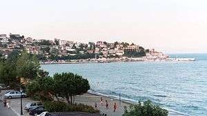
A view of the beach at Paralio Astros; the fortress (not pictured) is slightly to the left, at the summit of the peninsula.
Paralio Astros (Greek: Παράλιο Άστρος) is a port serving the inland town of Astros, Arcadia, Greece. It is part of the municipality North Kynouria and is considered a traditional settlement.
Paralio Astros possesses beaches and a harbour (renovated im 2015) which can accommodate small ships. A medieval Frankish fortress commands the heights of a peninsula called "The Island" which juts out to form the harbour. The main square is at the foot of the castle mount. The town is also home to the Archaeological Museum of Astros, founded in 1985.
Today, Astros's principal industry is tourism. It is a popular vacation spot for inhabitants of Tripoli and other parts of Greece. As of 2011, the port had 1,043 permanent inhabitants.
See also
References
- ↑ "Απογραφή Πληθυσμού - Κατοικιών 2011. ΜΟΝΙΜΟΣ Πληθυσμός" (in Greek). Hellenic Statistical Authority.
- ↑ Hellenic Statistical Authority - Table. The De Jure (registered) population 2011
This article is issued from Wikipedia - version of the 10/11/2016. The text is available under the Creative Commons Attribution/Share Alike but additional terms may apply for the media files.