Parapuã
| Parapuã | |
|---|---|
| Municipality | |
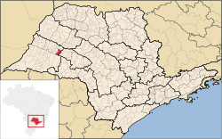 Location in São Paulo state | |
 Parapuã Location in Brazil | |
| Coordinates: 21°46′5″S 50°46′18″W / 21.76806°S 50.77167°WCoordinates: 21°46′5″S 50°46′18″W / 21.76806°S 50.77167°W | |
| Country |
|
| Region | Southeast Region |
| State | São Paulo |
| Area | |
| • Total | 366 km2 (141 sq mi) |
| Population (2015) | |
| • Total | 11,098 |
| • Density | 30/km2 (79/sq mi) |
| Time zone | BRT/BRST (UTC-3/-2) |
Parapuã is a municipality in the state of São Paulo in Brazil. The population is 11,098 (2015 est.) in an area of 366 km².[1] The elevation is 486 m. It was founded by Luiz de Souza Leão in 1934.
In the 1970s the county was called "Capital of the Coffee" because there were 12,500,000 coffee plants. But in 1975 a frost destroyed most of them. In spite of this, coffee is still important for the local economy, along with sugar cane and corn.
References
This article is issued from Wikipedia - version of the 10/11/2016. The text is available under the Creative Commons Attribution/Share Alike but additional terms may apply for the media files.