Parczew County
| Parczew County Powiat parczewski | |||
|---|---|---|---|
| County | |||
| |||
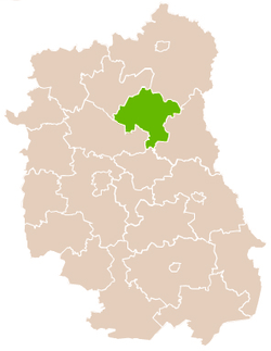 Location within the voivodeship | |||
| Coordinates (Parczew): 51°38′N 22°52′E / 51.633°N 22.867°ECoordinates: 51°38′N 22°52′E / 51.633°N 22.867°E | |||
| Country |
| ||
| Voivodeship | Lublin | ||
| Seat | Parczew | ||
| Gminas | |||
| Area | |||
| • Total | 952.62 km2 (367.81 sq mi) | ||
| Population (2006) | |||
| • Total | 36,512 | ||
| • Density | 38/km2 (99/sq mi) | ||
| • Urban | 10,281 | ||
| • Rural | 26,231 | ||
| Car plates | LPA | ||
| Website | http://www.parczew.pl | ||
Parczew County (Polish: powiat parczewski) is a unit of territorial administration and local government (powiat) in Lublin Voivodeship, eastern Poland. It was established on January 1, 1999, as a result of the Polish local government reforms passed in 1998. Its administrative seat and only town is Parczew, which lies 48 kilometres (30 mi) north-east of the regional capital Lublin.
The county covers an area of 952.62 square kilometres (367.8 sq mi). As of 2006, its total population is 36,512, including 10,281 in Parczew and a rural population of 26,231.
Neighbouring counties
Parczew County is bordered by Biała Podlaska County to the north, Włodawa County to the east, Łęczna County to the south, Lubartów County to the south-west and Radzyń Podlaski County to the north-west.
Administrative division
The county is subdivided into seven gminas (one urban-rural and six rural). These are listed in the following table, in descending order of population.
| Gmina | Type | Area (km²) |
Population (2006) |
Seat |
| Gmina Parczew | urban-rural | 146.2 | 14,852 | Parczew |
| Gmina Siemień | rural | 110.9 | 4,825 | Siemień |
| Gmina Jabłoń | rural | 111.0 | 4,177 | Jabłoń |
| Gmina Milanów | rural | 116.6 | 4,174 | Milanów |
| Gmina Dębowa Kłoda | rural | 188.3 | 3,991 | Dębowa Kłoda |
| Gmina Sosnowica | rural | 172.4 | 2,645 | Sosnowica |
| Gmina Podedwórze | rural | 107.2 | 1,848 | Podedwórze |
References
| Seat |  | |
|---|---|---|
| Urban-rural gmina | ||
| Rural gminas | ||
| City counties |
|  |
|---|---|---|
| Land counties | ||