Parkdale was a provincial riding electing Members of Provincial Parliament (MPP) to the Legislative Assembly of Ontario. The riding was created from the western part of Toronto West riding in 1914 and abolished in 1996 and redistributed into the Parkdale—High Park, Davenport and Trinity—Spadina ridings for the 1999 Ontario general election.
Boundaries
1914, 1919 & 1923
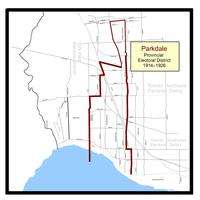
The original boundaries for the Parkdale, Ontario provincial electoral district from 1914 to 1926.
The Parkdale electoral district's first incarnation was for the 1914 Ontario general election. The following described boundaries were in force for the 1914, 1919 and 1923 Ontario general elections. Its boundaries started north-westerly at the city's northern limits with York Township, starting just south of Lavender Road, through the northern side of Rowntree Avenue, continuing just north of Innes Avenue, to its eastern border through Prospect Cemetery. The boundary then went southwards along Prospect Cemetery's eastern border until it converged with Lansdowne Avenue at St. Clair Avenue West. The eastern boundary followed Lansdowne all the way to Queen Street West, where it went eastward for a block, then went down the western side of Dunn Avenue to Lake Ontario.[1] The western boundary started at the eastern side of Keele Street (since 1921, this part of Keele Street is named Parkside Drive) at Queen Street West (since 1956, this is called The Queensway). From there, the boundary went north to Bloor Street West where it then went eastward to point east of Indian Road (or about half-way between present day Indian Road and Dorval Avenue). It then travelled north along Indian Road to Humberside Avenue. It went east along Humberside until it intersected with the western Grand Trunk Railway — after 1921, the Canadian National Railway (C.N.R.) — tracks. It went north-westerly until it intersected with the east-west Canadian Pacific Railway (C.P.R.) tracks. It went east along the C.P.R. tracks to the north-south Grand Trunk tracks, where the western boundary went north again along the tracks and connected with the northern boundary at the city limits, just south of Lavender Road.[2]
1926, 1929
For the 1926 election, Parkdale's northern-most boundary was the east-west C.P.R. tracks, just north of Dupont Avenue. The northern boundary then went east until the C.N.R. tracks near Lansdowne Avenue. From there, the boundary went south along the C.N.R. tracks to Dundas Street West. From there the eastern boundary went west on Dundas for about a block to the western side of Sorauren Avenue. It then plunged south along Sorauren to Queen Street West, then followed the southern part of Queen, easterly until Dowling Avenue. It then plunged south again to the southern border, Lake Ontario. The western boundary started on land at the western edge of High Park, which was the city limits. The western boundary continued north to Bloor Street West at Clendenan Avenue/Windego Way. It continued eastwards to Indian Road. It then travelled north along Indian Road to Humberside Avenue. From there it went east on Humberside until it intersected the western C.N.R. tracks. The boundary then went north-westerly until it intersected with the northern boundary at the east-west C.P.R.tracks. These boundaries were also in force for the 1929 Ontario general election as well.[1]
1934, 1937 & 1938
Redistribution gave Parkdale some of the area that was previously part of the Brockton electoral district. It also relinquished all the area north of Bloor Street West. The northern border was a straight line from approximately Clendenan Avenue straight to Brock Avenue. The boundary then went south along Brock Avenue to Queen Street West. It went east again, along the south side of Queen until Elm Grove Avenue. It went south along Elm Grove until King Street West. At King Street West, it went west along King's north side until Spencer Avenue. The boundary then moved south along Spencer's western side all the way to the southern boundary, Lake Ontario. The western boundary on land started at the city limits on the west side of High Park. It went straight along the City Limits until it again met Bloor Street West at approximately Clendenan Avenue/Wendigo Way.[3]
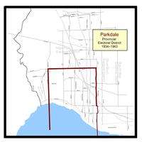
1943, 1945 & 1948
Parkdale's northern-most boundary was the east-west C.P.R. tracks, just north of Dupont Avenue. The northern boundary then went east until Lansdowne Avenue. It then went south to Wallace Avenue. It then went east along Wallace's south side to Brock Avenue. The boundary then went south along Brock Avenue to Queen Street West. It went east again, along the south side of Queen until Elm Grove. It went south along Elm Grove until King Street West. At King Street West, it went west along King's north side until Spencer Avenue. The boundary then moved south along Spencer's western side all the way to the southern boundary, Lake Ontario. The western boundary started on land at the western edge of High Park, which was the city limits. The western boundary continued north to Bloor Street West at Wendigo Way. It continued eastwards to Indian Road. It then travelled north along Indian Road to Humberside Avenue. From there it travelled along western C.N.R. tracks until it met up with the northern boundary at the east-west C.P.R.tracks.[4][5][6]
1951
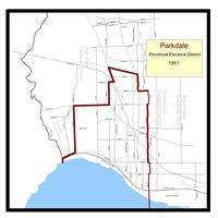
Parkdale provincial electoral district 1951
Parkdale's northern-most boundary was the east-west C.P.R. tracks, just north of Dupont Avenue. The northern boundary then went east untilLansdowne Avenue. It then went south to Wallace Avenue. It then went east along Wallace's south side to Brock Avenue. The boundary then went south along Brock Avenue to Queen Street West. It went east again, along the south side of Queen until Elm Grove. It went south along Elm Grove until King Street West. At King Street West, it went west along King's north side until Spencer Avenue. The boundary then moved south along Spencer's western side all the way to the southern boundary, Lake Ontario. The western boundary started on the eastern edge of the Humber River, going north to the C.N.R. Lakeshore tracks. It went east along these tracks to the city limits, at the western edge of High Park. The western boundary continued in a straight-line north to Bloor Street West, near Wendigo Way. It continued eastwards to Indian Road. It then travelled north along Indian Road to Humberside Avenue. From there it travelled along western C.N.R. tracks until it met up with the northern boundary at the east-west C.P.R.tracks.[7][8]
1955, 1959 & 1963
Parkdale's northern-most boundary was the east-west C.P.R. tracks, just north of Dupont Avenue. The northern boundary then went east until Lansdowne Avenue. It then went south to Wallace Avenue. It then went east along Wallace's south side to Brock Avenue. The boundary then went south along Brock Avenue to Queen Street West. It went east again, along the south side of Queen until Elm Grove Avenue. It went south along Elm Grove until King Street West. At King Street West, it went west along King's north side until Spencer Avenue. The boundary then moved south along Spencer's western side all the way to the southern boundary, Lake Ontario. The western boundary started on the eastern edge of the Humber River, going north to the C.N.R. Lakeshore tracks. It went east along these tracks to the city limits, at the western edge of High Park. The western boundary continued in a straight-line north to Bloor Street West, near Wendigo Way. It continued eastwards to the C.N.R./C.P.R. tracks. From there it travelled north-westerly along C.N.R. tracks until it met up with the northern boundary at the east-west C.P.R.tracks.[8][9][10]
1967, 1971

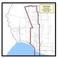
Parkdale provincial electoral district from 1967–1975
Prior to the 1967 election, a major redrawing of the boundaries took place in 1966. Parkdale's northern-most boundary was the city limits with The Borough of York, starting south of Lavender Road, through the northern side of Rowntree Avenue, continuing just north of Innes Avenue, to its eastern border through Prospect Cemetery. The boundary then went southwards from a point starting across the street from Morrison Avenue on Harvie Avenue. The eastern border went down Harvie until it turned east at St. Clair Avenue West, going as far as Greenlaw Avenue. It then went south on Greenlaw until Davenport Road. The boundary continued south along Primrose Avenue until the east-west C.P.R. railway tracks. It then continued south along Emerson Avenue until it reached Wallace Avenue. It went east along Wallace until Brock Avenue. It then continued south along Brock Avenue all the way to Queen Street West, where it went eastward for a block, then went down the western side of Elm Grove Avenue toKing Street West. The boundary then jogged west along King for about a block to Spencer Avenue. It then went south all the way to Lake Ontario. The western boundary started on the lakefront, at approximately a point 250 metres directly south of Dowling Avenue. It went north along Dowling until King Street West. It jogged slightly west and continued north along Beatty Avenue to Queen Street West. A short jog east along Queen before continuing north along Sorauren Avenue to Dundas Street West. It went east along the southern side of Dundas to the C.N.R./C.P.R. tracks. The boundary followed the C.N.R. tracks in a north-westerly direction up to the old York-Toronto city limits.[11][12]
1975, 1977, 1981 & 1985
Parkdale provincial electoral district 1975—1987
The 1975 boundary redistribution gave the Parkdale electoral district some territory from the old High Park district. The boundaries were in effect for the 1975 Ontario general election to the 1985 Ontario general election. Parkdale's northern-most boundary was the city's northern boundary with The Borough of York, starting south of Lavender Road, through the northern side of Rowntree Avenue, continuing just north of Innes Avenue, to its eastern border through Prospect Cemetery. The boundary then went southwards from a point starting across the street from Morrison Avenue on Harvie Avenue. The eastern border went down Harvie until it turned east at St. Clair Avenue West, going as far as Greenlaw Ave. It then went south on Greenlaw until Davenport Road. The boundary continued south along Primrose Avenue until the east-west C.P.R. railway tracks. It then continued south along Emerson Avenue until it reached Wallace Avenue. It went east along Wallace until Brock Avenue. It then continued south along Brock Avenue all the way to Queen Street West, where it went eastward for a block, then went down the western side of Elm Grove Avenue to King Street West. The boundary then jogged west along King for about a block to Spencer Avenue. It then went south all the way to Lake Ontario. The western boundary started on the lakefront, at approximately a point 250 metres south of Dowling Avenue. It went north to Dowling Avenue and the Gardiner Expressway. It kept going west along the westbound lanes on the Gardiner to a point south of Sunnyside Avenue. It then proceeded to go east along the south side of The Queensway until it reached Roncesvalles Avenue. From there, the boundary went north to Bloor Street West where it then went eastward to the north-south C.P.R. railway tracks. It then travelled north-west along C.P.R. tracks and connected with the northern boundary at the city limits, just south of Lavender Road.[13]
1987, 1990 & 1995
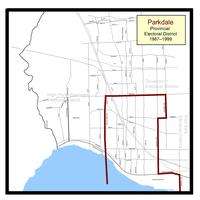
The final configuration of the Parkdale electoral district 1987—1999.
The final electoral district redistribution was in place for the 1987 Ontario general election, and pushed Parkdale's boundaries a bit further east. The northern border was a straight line from the intersection of Bloor Street West and Dundas Street West, straight across Bloor to Ossington Avenue. The boundary then went south along Ossington Avenue to College Street. It went west along College until it reached Dovercourt Road. The boundary continued south along Dovercourt, crossing King Street West to Atlantic Avenue where it continued south until the Gardiner Expressway west-bound lanes. The boundary then jogged east along the Gardiner to Strachan Avenue. It then went south on Strachan to Lake Ontario. The western boundary on land started at the waterfront immediately south of Roncesvalles Avenue. The boundary then went north along Roncesvalles to Dundas Street West, and continued on Dundas until it met up with Bloor Street West.[14] The district was abolished in 1996, when provincial legislation redistributed all provincial districts to follow the same boundaries as Ontario's federal electoral districts.[15]
Members of Provincial Parliament
Election results
1910s
1920s

Parkdale provincial electoral district from 1926 to 1934.
Ontario general election, 1929
|
Party |
Candidate |
Votes[23] |
Vote % |
|---|
| |
Conservative |
William H. Price |
6,195 |
70.5% |
| |
Liberal |
James F. Coughlin |
2,211 |
25.2% |
| |
Independent |
Duncan McIntosh |
380 |
4.3% |
|
|
Total |
8,786 |
|
1930s
Parkdale provincial electoral district from 1934 to 1943.
Parkdale By-Election, 1938[nb 4]
|
Party |
Candidate |
Votes[26] |
Vote % |
|---|
| |
Conservative |
William James Stewart |
8,758 |
69.8% |
| |
Co-operative Commonwealth |
Russell Harvey |
3,440 |
27.4% |
| |
Independent Liberal [nb 5] |
Robert Harding |
268 |
2.1% |
| |
Socialist-Labour |
George Thomson |
87 |
0.7% |
|
|
Total |
12,553 |
|
1940s

Parkdale provincial electoral district as it existed from 1943 to 1951.
Ontario general election, 1943
|
Party |
Candidate |
Votes[27] |
Vote % |
|---|
| |
Conservative |
William James Stewart |
8,621 |
45.1% |
| |
Co-operative Commonwealth |
Ford Brand |
6,503 |
34.0% |
| |
Liberal |
Jack Bennett |
4003 |
20.9% |
|
|
Total |
19,127 |
|
Ontario general election, 1945
|
Party |
Candidate |
Votes[28] |
Vote % |
|---|
| |
Conservative |
William James Stewart |
13,086 |
47.7% |
| |
Liberal |
Jack Bennett |
6,983 |
25.5% |
| |
Co-operative Commonwealth |
Arthur Waters |
6,092 |
22.2% |
|
|
Labor–Progressive | A. E. Sculthorpe | 1,251 | 4.6% |
|
|
Total |
27,412 |
|
Ontario general election, 1948
|
Party |
Candidate |
Votes[29] |
Vote % |
|---|
| |
Co-operative Commonwealth |
Lloyd Fell |
11,980 |
39.39% |
| |
Conservative |
William James Stewart |
11,379 |
37.41% |
| |
Liberal |
Jack Bennett |
7,057 |
23.20% |
|
|
Total |
30,416 |
|
1950s
Ontario general election, 1951
|
Party |
Candidate |
Votes[30] |
Vote % |
|---|
| |
Conservative |
William James Stewart |
10,859 |
42.56% |
| |
Co-operative Commonwealth |
Lloyd Fell |
8,394 |
32.90% |
| |
Liberal |
James E. Colby |
6,263 |
24.55% |
|
|
Total |
25,516 |
|

Parkdale provincial electoral district 1955–1967
Ontario general election, 1959
|
Party |
Candidate |
Votes[32] |
Vote % |
|---|
| |
Liberal |
James Trotter |
9,444 |
47.49% |
| |
Conservative |
William James Stewart |
6,525 |
32.81% |
| |
Co-operative Commonwealth |
Charles Daley |
3,919 |
19.71% |
|
|
Total |
19,888 |
|
1960s
Ontario general election, 1963
|
Party |
Candidate |
Votes[33] |
Vote % |
|---|
| |
Liberal |
James Trotter |
9,065 |
44.86% |
| |
Conservative |
Casimier Bielski |
6,834 |
33.82% |
| |
New Democrat |
Archie Chisholm |
4,309 |
21.32% |
|
|
Total |
20,208 |
|
Ontario general election, 1967
|
Party |
Candidate |
Votes[34] |
Vote % |
|---|
| |
Liberal |
James Trotter |
5,584 |
38.51% |
| |
New Democrat |
Janos Dukszta |
4,796 |
33.08% |
| |
Conservative |
Robert Maksymec |
4,119 |
28.41% |
|
|
Total |
14,499 |
|
1970s
Ontario general election, 1971
|
Party |
Candidate |
Votes[35] |
Vote % |
|---|
| |
New Democrat |
Jan Dukszta |
5,954 |
36.3 |
| |
Liberal |
James Trotter |
5,531 |
33.8 |
| |
Conservative |
Cas Bielski |
4,901 |
29.9 |
|
|
Total |
16,386 |
Ontario general election, 1975
|
Party |
Candidate |
Votes[36] |
Vote % |
|---|
| |
New Democrat |
Jan Dukszta |
7,158 |
41.8 |
| |
Liberal |
Stan Mamak |
5,531 |
32.3 |
| |
Conservative |
Bob Orr |
3,846 |
22.5 |
|
Communist | K. McQuaig | 393 | 2.3 |
| |
Independent |
Robert A. McKay |
193 |
1.1 |
|
|
Total |
17,121 |
|
1980s
Ontario general election, 1981
|
Party |
Candidate |
Votes[38] |
Vote % |
|---|
| |
Liberal |
Tony Ruprecht |
6,939 |
42.2 |
| |
New Democrat |
Jan Dukszta |
6,015 |
36.6 |
| |
Conservative |
Verrol Whitmore |
2,910 |
17.9 |
| |
Independent |
Bill McGinnis |
312 |
1.9 |
|
Communist | Anna Larsen | 257 | 1.6 |
|
|
Total |
16,433 |
|
Ontario general election, 1985
|
Party |
Candidate |
Votes[39] |
Vote % |
|---|
| |
Liberal |
Tony Ruprecht |
12,067 |
62.4 |
| |
New Democrat |
Richard Gilbert |
5,224 |
27.0 |
| |
Conservative |
Tessie Jew |
2,052 |
10.6 |
|
|
Total |
19,333 |
|
Ontario general election, 1987
|
Party |
Candidate |
Votes[40] |
Vote % |
|---|
| |
Liberal |
Tony Ruprecht |
13,526 |
71.0 |
| |
New Democrat |
Vasco Dos Santos |
3,661 |
19.2 |
| |
Conservative |
Charles Olino |
796 |
4.2 |
|
Family Coalition | Clara Marmelo | 308 | 1.6 |
|
Libertarian | Donny Humi | 291 | 1.6 |
|
Communist | Gordon Mossic | 183 | 1.0 |
| |
Independent |
Carmilo Tiqui |
179 |
0.9 |
| |
Independent |
Nancy Van Schouvan |
114 |
0.6 |
|
|
Total |
19,058 |
|
1990s
Ontario general election, 1990
|
Party |
Candidate |
Votes[41] |
Vote % |
|---|
| |
Liberal |
Tony Ruprecht |
8,064 |
46.3 |
| |
New Democrat |
Sheena Weir |
7,563 |
43.4 |
| |
Conservative |
John Swotenham |
941 |
5.4 |
|
Green | Robert Hunter | 319 | 1.8 |
|
Libertarian | James McCulloch | 246 | 1.4 |
| |
Independent |
Debra Stone |
167 |
1.0 |
| |
Independent |
Joe Young |
112 |
0.6 |
|
|
Total |
17,412 |
|
References
Notes
- ↑ In 1938, the title of Member of the Legislative Assembly was officially changed to Member of Provincial Parliament. Previously, it was unofficially used in the media and in the Legislature.
- ↑ McBrien died in office on 2 July 1938, forcing a by-election on 5 October 1938
- ↑ 1919 was the first election to allow women to vote, more than doubling the vote counts in each riding.
- ↑ Incumbent MPP Fred McBrien died in office on 2 July 1938. This by-election was called for 5 October 1938 to replace him as Parkdale's representative in the Ontario Legislature.
- ↑ Liberal Premier Mitchell Hepburn respected recently deceased Parkdale MPP Fred McBrien, a Conservative, and requested that the Liberal Party not run a candidate in the by-election to replace him. The party agreed, and Robert Harding did not have Liberal Party backing and had to run as an "Independent Liberal".
Citations
- 1 2 "Map of Toronto showing Provincial election ridings and City Limits". Toronto Daily Star. Toronto. 1926-11-06. p. 22.
- ↑ "Toronto Ridings As They Are Now–How Ten Seats Are Distributed". The Toronto Daily Star. Toronto. 1914-06-12. p. 5.
- ↑ "Toronto and Suburban Ridings in June 19th Election Fight". Toronto Daily Star. Toronto. 1934-06-12. p. 3.
- ↑ "Here Are the Boundaries of Toronto Ridings for the Aug. 4 Election". Toronto Daily Star. Toronto. 1943-07-24. p. 9.
- ↑ "Candidates and their Bailiwicks for next Monday's Provincial Election; 69 Run, 17 Can Win". Toronto Daily Star. Toronto. 1945-05-29. p. 3. Retrieved 2011-12-05.
- ↑ "Toronto Ridings". Toronto Daily Star. Toronto. 1948-06-05. p. 40.
- ↑ "Toronto-Parkdale:Three-Time PC Winner Seeks to Unseat CCF". The Globe and Mail. Toronto. 1951-11-10. p. 4.
- 1 2 "City of Toronto Annexations Map". Online Maps. Toronto: Toronto Public Archives. 1967. Retrieved 2012-01-21.
- ↑ Electoral map of the Province of Ontario (Map No. 33a) (Map). Cartography by Division of Surveys and Engineering, Department of Lands and Forests. Toronto: Queen's Printer for Ontario. 1955.
To find this map in the Ontario Archives, please see sub-series title "Ontario electoral district maps", reference code RG 1-211, File item code RG 1-211-0-0-5.
- ↑ Forsyth, Robert (1963-09-12). "Province of Ontario General Election 1963 The Voter's List Act Part III: Parkdale". The Toronto Daily Star. Toronto. p. 31.
- ↑ Provincial Electoral Districts (Map). Cartography by Lands and Surveys Branch, Department of Lands and Forests. Toronto: Queen's Printer for Ontario. 1967.
To find this map in the Ontario Archives, please see sub-series title "Ontario electoral district maps", reference code RG 1-211, File item code RG 1-211-0-0-06.
- ↑ Provincial Electoral Districts in Metropolitan Toronto (Map). Cartography by Lands and Surveys Branch, Department of Lands and Forests. Toronto: Queen's Printer for Ontario. 1971.
To find this map in the Ontario Archives, please see sub-series title "Ontario electoral district maps", reference code RG 1-211, File item code RG 1-211-0-0-13.
- ↑ Potter, Ken (1975-09-01). "Parkdale race turns on local issues". The Toronto Star. Toronto. p. A7.
- ↑ Hall, Joseph (1987-09-02). "Housing proves most pressing issue". The Toronto Star. Toronto. p. A7.
- ↑ Rusk, James (1996-10-02). "Harris redraws electoral map". The Globe and Mail. Toronto. p. A4.
- ↑ For a listing of each MPP's Queen's Park curriculum vitae see below:
- For William Herbert Price's Legislative Assembly information see "William Herbert Price, MPP". Parliamentary History. Toronto: Legislative Assembly of Ontario. 2011. Retrieved 2011-11-30.
- For Fred McBrien's Legislative Assembly information see "Frederick George McBrien, MPP". Parliamentary History. Toronto: Legislative Assembly of Ontario. 2011. Retrieved 2011-11-29.
- For William James Stewart's Legislative Assembly information see "William James Stewart, MPP". Parliamentary History. Toronto: Legislative Assembly of Ontario. 2011. Retrieved 2011-11-29.
- For Lloyd Fell's Legislative Assembly information see "Lloyd F. K. Fell, MPP". Parliamentary History. Toronto: Legislative Assembly of Ontario. 2011. Retrieved 2011-11-29.
- For James Beecham Trotter's Legislative Assembly information see "James Beecham Trotter, MPP". Parliamentary History. Toronto: Legislative Assembly of Ontario. 2011. Retrieved 2011-11-30.
- For Jan Dukszta's Legislative Assembly information see "Jan Dukszta, MPP". Parliamentary History. Toronto: Legislative Assembly of Ontario. 2011. Retrieved 2011-11-30.
- For Tony Ruprecht's Legislative Assembly information see "Tony Ruprecht, MPP". Parliamentary History. Toronto: Legislative Assembly of Ontario. 2011. Retrieved 2011-11-30.
- ↑ "Price Carries Parkdale Riding". The Toronto World. Toronto. 1914-06-30. p. 3. Retrieved 2012-05-15.
- ↑ "The Details in the Voting in Toronto Ridings". The Toronto Daily Star. Toronto. 1919-10-21. p. 3.
- ↑ "Ont. Candidates and last election figures". The Globe. Toronto. 1919-10-14. p. 2.
- ↑ "The Vote in Toronto and the York ridings". The Toronto Daily Star. Toronto. 1923-06-26. p. 5.
- ↑ "Sweep by Tories Returns 15 Wets in Toronto Seats". The Toronto Daily Star. Toronto. 1926-12-01. p. 1.
- ↑ "Ontario General Elections and By-elections, 1923-1926". The Globe. Toronto. 1926-12-02. p. 7.
- ↑ "Vote Cast and Personnel of the New Ontario Legislature". The Toronto Daily Star. Toronto. 1929-10-31. p. 43.
- ↑ "Detailed Election Results". The Globe. Toronto. 1934-06-21. p. 3.
- ↑ "Ontario Voted By Ridings". The Toronto Daily Star. Toronto. 1937-10-07. p. 5.
- ↑ "Stewart Carries Parkdale Majority More Than 5,000". The Toronto Daily Star. Toronto. 1938-10-06. p. 25.
- ↑ Canadian Press (1943-08-05). "Ontario Election Results". The Gazette. Montreal. p. 12.
- ↑ Canadian Press (1945-06-05). "How Ontario Electors Voted in all 90 Ridings". The Toronto Daily Star. Toronto. p. 5. Retrieved 2012-03-03.
- ↑ Canadian Press (1948-06-08). "How Ontario Electors Voted in all 90 Ridings". The Toronto Daily Star. Toronto. p. 24.
- ↑ Canadian Press (1951-11-22). "Complete Ontario Vote". The Montreal Gazette. Montreal. p. 4. Retrieved 2012-04-22.
- ↑ Canadian Press (1955-06-10). "Complete Results of Ontario Voting by Constituencies". The Ottawa Citizen. Ottawa. p. 4. Retrieved 2012-04-22.
- ↑ Canadian Press (1959-06-12). "Complete Results of Ontario Voting by Constituencies". The Ottawa Citizen. Ottawa. p. 26. Retrieved 2012-04-22.
- ↑ Canadian Press (1963-09-26). "78 in Tory Blue Wave -- 23 Is All Grits Saved". The Windsor Star. Windsor, Ontario. p. 25. Retrieved 2012-04-24.
- ↑ Canadian Press (1967-10-18). "Tories win, but...". The Windsor Star. Windsor, Ontario. p. B2. Retrieved 2012-04-30.
- ↑ Canadian Press (1971-10-22). "Here's who won on the Metro ridings". The Toronto Daily Star. Toronto. p. 12.
- ↑ Canadian Press (1975-09-19). "Results from the 29 ridings in Metro". The Toronto Daily Star. Toronto. p. A18.
- ↑ Canadian Press (1977-06-10). "How they voted in Metro area". The Toronto Daily Star. Toronto. p. A10.
- ↑ Canadian Press (1981-03-20). "Election results for Metro Toronto ridings". The Windsor Star. Windsor, Ontario. p. 22. Retrieved 2012-08-24.
- ↑ Canadian Press (1985-05-03). "The night the Tories tumbled; riding by riding results". Ottawa Citizen. Toronto. p. 43. Retrieved 2012-05-10.
- ↑ "How Metro-Area Voted". The Toronto Daily Star. Toronto. 1987-09-11. p. A12.
- ↑ "How Metro-Area Voted". The Toronto Daily Star. Toronto. 1990-09-07. p. A10.
- ↑ "Summary of Valid Ballots by Candidate". Elections Ontario. 1995-06-08. Retrieved 2012-09-04.
