Parrano
This article is about the Italian municipality. For the cheese, see Parrano cheese.
| Parrano | |
|---|---|
| Comune | |
| Comune di Parrano | |
 Parrano Location of Parrano in Italy | |
| Coordinates: 42°52′N 12°7′E / 42.867°N 12.117°ECoordinates: 42°52′N 12°7′E / 42.867°N 12.117°E | |
| Country | Italy |
| Region | Umbria |
| Province / Metropolitan city | Province of Terni (TR) |
| Frazioni | Cantone, Frattaguida, Pievelunga |
| Area | |
| • Total | 39.9 km2 (15.4 sq mi) |
| Elevation | 441 m (1,447 ft) |
| Population (Dec. 2004) | |
| • Total | 589 |
| • Density | 15/km2 (38/sq mi) |
| Time zone | CET (UTC+1) |
| • Summer (DST) | CEST (UTC+2) |
| Postal code | 05010 |
| Dialing code | 0763 |
| Website | Official website |
Parrano is a comune (municipality) in the Province of Terni in the Italian region Umbria, located about 35 km southwest of Perugia and about 50 km northwest of Terni. As of 31 December 2004, it had a population of 589 and an area of 39.9 km².[1]
The municipality of Parrano contains the frazioni (subdivisions, mainly villages and hamlets) Cantone, Frattaguida, and Pievelunga.
Parrano borders the following municipalities: Ficulle, Montegabbione, San Venanzo.
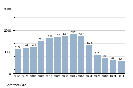
Demographic evolution
References
External links
This article is issued from Wikipedia - version of the 7/15/2016. The text is available under the Creative Commons Attribution/Share Alike but additional terms may apply for the media files.