Parunthumpara
| Parunthumpara പരുന്തുംപാറ | |
|---|---|
| Tourist destination | |
|
Tagore head at Parunthumpara | |
 Parunthumpara Location in Kerala, India | |
| Coordinates: 9°33′13″N 77°02′09″E / 9.553482°N 77.035827°ECoordinates: 9°33′13″N 77°02′09″E / 9.553482°N 77.035827°E | |
| Country |
|
| State | Kerala |
| District | Idukki |
| Government | |
| • Type | Panchayath |
| Languages | |
| • Official | Malayalam, English |
| Time zone | IST (UTC+5:30) |
| Vehicle registration | KL-37 |
| Nearest city | Peermade |
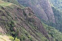
Parunthumpara is a village in the Indian state of Kerala's Idukki District.[1] It is a small scenic location near Wagamon en route to Peerumedu. Parunthin Para also known as 'Parunthumpara' (the eagle rock). From here, the Makarajyothi of Sabarimala is visible. The main attractions of Parunthumpara are Suicide Point and Tagor Head (a rock that appears to have the shape of Tagor, an Indian poet's, head). A nearby tourist spot is Thekkady.
Parunthumpara is a small village, located between Peermade and Thekkady. The word parunth in the local language means Eagle and para means rock. It is called Parunthumpara or eagle rock because of a large area around like an eagle.It is 6 km from Peermade, 25 km from Thekkady and 3 km From National Highway 220.( Kottayam Kumily road).This area provides a bird's eye view of an endless stretch of green forest land and low-lying areas.Parunthumpara is six km from Peerumade on National Highway 220 and is increasingly being visited by tourists who are on their way to Thekkady and others as well. If the sky is clear, visitors can get the view of the Sabarimala forests.
Easily accessible through the narrow ghat road from Kallar Junction, this hill station stands out for its sprawling grasslands where the families can enjoy a few quiet moments, away from the hustle and bustle of the city life. A perfect choice for those who wish to have a holiday off the beaten track and to explore the unseen and the unexplored beauty of the pristine forests around, Parunthumpara has been attracting a large number of domestic tourists during weekends.
Though the place is yet to be included in the tourism map of the district, the place can stand up to any other hill stations.
However, the steep hills also pose a threat to reckless visitors. There are a few deep slopes and one should be careful while visiting Parunthumpara.
The District Tourism Promotion Council plans to develop Parunthumpara as a hill station and as a stopover place for tourists who come from Kumarakom to Thekkady. There are two main roads through which the domestic and international tourists reach the district — from Nedumbassery to Munnar and from Kumarakom to Thekkady. Between these main tourism destinations, there are a few must-see places and Parunthumpara had been identified as one among them.But this place lacks basic facilities like lodging and boarding.
A project had been submitted to the government for constructing a protective wall and for allotting a parking area so as to prevent the entry of vehicles on the grasslands.

Sabarimala pilgrims visit the area to witness makarajyothi, making it a busy place during the pilgrimage season.
References
- ↑ "Census of India: Villages". Retrieved 2010-09-16.
|first1=missing|last1=in Authors list (help)
External links
| Wikimedia Commons has media related to Parunthumpara. |