Pascoag, Rhode Island
| Pascoag, Rhode Island | |
|---|---|
| Census-designated place | |
|
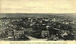
Pascoag c. 1900 | |
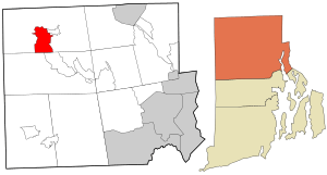 Location in Providence County and the state of Rhode Island. | |
| Coordinates: 41°57′27″N 71°42′21″W / 41.95750°N 71.70583°WCoordinates: 41°57′27″N 71°42′21″W / 41.95750°N 71.70583°W | |
| Country | United States |
| State | Rhode Island |
| County | Providence |
| Area | |
| • Total | 5.5 sq mi (14.1 km2) |
| • Land | 5.0 sq mi (13.0 km2) |
| • Water | 0.4 sq mi (1.1 km2) |
| Elevation | 427 ft (130 m) |
| Population (2010) | |
| • Total | 4,577 |
| • Density | 830/sq mi (320/km2) |
| Time zone | Eastern (EST) (UTC-5) |
| • Summer (DST) | EDT (UTC-4) |
| ZIP code | 02859 |
| Area code(s) | 401 |
| FIPS code | 44-54460[1] |
| GNIS feature ID | 1218912[2] |
Pascoag /ˈpæskoʊɡ/ is a census-designated place (CDP) and village in Providence County, Rhode Island, United States. The population was 4,577 at the 2010 census.[3] Pascoag is one of at least eight villages that make up the town of Burrillville.
Geography
Pascoag is located at 41°57′27″N 71°42′21″W / 41.95750°N 71.70583°W (41.957401, -71.705957).[4] The village is centered on the Pascoag River at its outlet from the Pascoag Reservoir. The river drops 60 feet (18 m) through the village, providing ample power for industry in the village's early days. According to the United States Census Bureau, the CDP has a total area of 14.1 km² (5.5 mi²). 13.0 km² (5.0 mi²) of it is land and 1.1 km² (0.4 mi²) of it (7.88%) is water.
Demographics
As of the census[1] of 2000, there were 4,742 people, 1,642 households, and 1,175 families residing in the CDP. The population density was 364.7/km² (944.4/mi²). There were 1,743 housing units at an average density of 134.1/km² (347.1/mi²). The racial makeup of the CDP was 98.33% White, 0.36% African American, 0.32% Native American, 0.27% Asian, 0.02% Pacific Islander, 0.17% from other races, and 0.53% from two or more races. Hispanic or Latino of any race were 1.03% of the population.
There were 1,642 households out of which 37.6% had children under the age of 18 living with them, 56.3% were married couples living together, 10.7% had a female householder with no husband present, and 28.4% were non-families. 23.0% of all households were made up of individuals and 10.1% had someone living alone who was 65 years of age or older. The average household size was 2.72 and the average family size was 3.20.
In the CDP the population was spread out with 26.5% under the age of 18, 7.4% from 18 to 24, 31.0% from 25 to 44, 19.7% from 45 to 64, and 15.4% who were 65 years of age or older. The median age was 37 years. For every 100 females there were 90.1 males. For every 100 females age 18 and over, there were 85.1 males.
The median income for a household in the CDP was $48,778, and the median income for a family was $54,391. Males had a median income of $37,957 versus $27,241 for females. The per capita income for the CDP was $20,322. About 6.4% of families and 9.0% of the population were below the poverty line, including 9.7% of those under age 18 and 15.4% of those age 65 or over.
History
The name of Burrillville's principal village, Pascoag, named after the stream upon which it is located, probably derives from an Algonquian Indian root. The Nipmuc word for snake was rendered "askug" by Roger Williams in his A Key Into the Language of America, and "askoog" by the Reverend John Eliot in his Algonquian translation of the Bible.
Pascoag can trace its origins back to the first half of the 18th century, when a saw mill and other businesses were built in what is now the village center. In the 19th century, Pascoag became a textile manufacturing town, an industry that continued until after World War II. From 1891 until the 1930s the Woonsocket and Pascoag Railroad operated trains to Pascoag, but the line (currently operated by the Providence and Worcester Railroad) now terminates in Slatersville.
The horror author H. P. Lovecraft set part of his story "The Horror at Red Hook" (1925) in Pascoag.
Recent history includes an incident involving groundwater contamination. A test of the groundwater conducted on September 14, 2001, showed that the water contained the ether MTBE (methyl tertiary-butyl ether) at levels of over 350 ppb (parts per billion).[5] This was the first public statement concerning the presence of MTBE in Pascoag drinking water, though residents claim to have detected it as early as May 2001. MTBE is a gasoline additive intended to enhance octane levels. It is believed to have come from leaking tanks at a local Exxon Mobil gas station. As the situation was resolved over the following months, nearly 1,500 residents of Pascoag responded by filing a lawsuit against Exxon Mobil through the law offices of Napoli, Kaiser, and Bern. Exxon Mobil has signed off on a $7 million settlement with residents of Pascoag in May 2012, to cover the cost of having the Pascoag Public Utility District bore new wells.
Historic sites
- Pascoag Grammar School (1917)
References
- 1 2 "American FactFinder". United States Census Bureau. Retrieved 2008-01-31.
- ↑ "US Board on Geographic Names". United States Geological Survey. 2007-10-25. Retrieved 2008-01-31.
- ↑ "Profile of General Population and Housing Characteristics: 2010 Demographic Profile Data (DP-1): Pascoag CDP, Rhode Island". U.S. Census Bureau, American Factfinder. Retrieved October 15, 2012.
- ↑ "US Gazetteer files: 2010, 2000, and 1990". United States Census Bureau. 2011-02-12. Retrieved 2011-04-23.
- ↑ "MTBE Update". Pascoag Utility District. October 4, 2001. Retrieved October 16, 2012.
External links
- History of Pascoag
- Pascoag Public Library
- Pascoag Utility District
- Pascoag Riverwalk, at Town of Burrillville website
Municipalities and communities of Providence County, Rhode Island, United States | ||
|---|---|---|
| Cities |  | |
| Towns | ||
| Villages | ||