Passo Garlenda
| Passo Garlenda | |
|---|---|
|
Passo Garlenda from Tanaro valley | |
| Elevation | 2,021 m (6,631 ft)[1] |
| Traversed by | Alta Via dei Monti Liguri |
| Location | Liguria, Italy |
| Range | Ligurian Alps |
| Coordinates | 44°03′03″N 7°44′53″E / 44.05081°N 7.74792°ECoordinates: 44°03′03″N 7°44′53″E / 44.05081°N 7.74792°E |
 Passo Garlenda Location of Passo Garlenda | |

Passo Garlenda or Passo di Garlenda[2](2021 m) is a mountain pass in the Province of Imperia (Italy). It connects Verdeggia, located in the Argentina Valley, with Monesi di Triora, located in Tanaro Valley.
Geography
Passo Garlenda is located on the main chain of the Alps between Monte Frontè (2152 m) and Monte Cimonasso [3] (2078 m). Near the pass there are some ruins of old barraks.[2]
Hiking
The pass is accessible by off-road mountain paths coming from the nearby valleys and is crossed by the Alta Via dei Monti Liguri, a long-distance trail from Ventimiglia (province of Imperia) to Bolano (province of La Spezia).[4]
Mountain huts
- Rifugio Sanremo (2,054 m)
See also
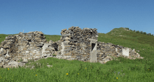
Ruins of an old barrak near the pass
References
- ↑ Alpi Marittime e Liguri, map 1:50.000 n.8, Istituto Geografico Centrale (Turin)
- 1 2 Saccarello (Monte) e Monte Frontè anello da Monesi, web page of b.bepun on www.gulliver.it (access: July 29, 2015)
- ↑ Also named Monte Simonasso
- ↑ IM / 01 - Anello del Saccarello, web page on www.altaviadeimontiliguri.it (access: July 29, 2015)
![]() Media related to Passo Garlenda at Wikimedia Commons
Media related to Passo Garlenda at Wikimedia Commons
This article is issued from Wikipedia - version of the 1/20/2016. The text is available under the Creative Commons Attribution/Share Alike but additional terms may apply for the media files.