Tanaro
| Tanaro | |
|---|---|
 Near Alessandria | |
 | |
| Country | Italy |
| Basin | |
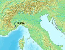
| Main source | Ligurian Alps, on the slopes of Monte Saccarello |
| River mouth | Po near Bassignana (AL) |
| Basin size | 8,234 km2 (3,179 sq mi) |
| Physical characteristics | |
| Length | 276 km (171 mi) |
| Discharge |
|
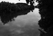
The Tanaro (Italian pronunciation: [ˈtaːnaro]), known as Tanarus in ancient times and Tane or Tani in piedmontese language, is a 276-kilometre (171 mi) long river in northwestern Italy. The river begins in the Ligurian Alps, near the border with France, and is the most significant right-side tributary to the Po in terms of length, size of drainage basin (partly Alpine, partly Apennine), and discharge.
Geography
Sources
The Tanaro proper begins in Liguria at the confluence of two small streams, the sources of which are in Piedmont: the Tanarello and the Negrone.
The main source of the Tanarello is on the slopes of Monte Saccarello above Monesi, a village belonging to the commune of Triora. This mountain straddles the French département of Alpes-Maritimes, the Piedmontese province of Cuneo and the Ligurian province of Imperia and marks the juncture of the watersheds between three drainage basins: that of the Tanaro itself; that of the Roya (Italian Roia), which rises in France but enters the sea at Ventimiglia; and the Argentina, which flows into the Ligurian Sea at Taggia.
The sources of the Negrone are some 10 kilometres (6 mi) to the north, south of Punta Marguareis and very close to the French border.
Course
The Tanaro flows past the towns Ceva, Alba, Asti, and Alessandria before entering the Po near Bassignana in the Province of Alessandria. At its confluence with Po, it is longer by about 50 kilometres (31 mi) than the upper Po,[1] a case similar to the famous Missouri tributary being longer than Mississippi in the United States.
Tributaries
The main tributaries to the Tanaro are the Stura di Demonte and the Borbore from the left and the Bormida and the Belbo from the right.
Regime
The flow is subject to a great deal of seasonal variation. Although the river has an Alpine origin, which is unique among the Po’s right-side tributaries, the Ligurian Alps are of an insufficient elevation and too close to the sea to allow for the formation of snow fields or glaciers large enough to provide a steady source of water during the summer. Furthermore, the Alpine zone forms only a part of the basin drained by the Tanaro. The seasonal regime of the river is therefore more typical of an Apennine stream, with a maximum discharge that can reach 1,700 cubic metres per second (60,000 cu ft/s), in spring and autumn and a very low rate of flow in the summer.
Flood events
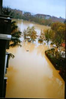
The river is highly prone to flooding. During the two hundred-year period between 1801 and 2001, sections of the Tanaro basin were affected by floods on 136 occasions, the most devastating being those in November 1994, when the whole of the river valley was affected by severe flooding, especially the town of Alessandria.
History
The left bank of the Tanaro River near Asti is the scene of the Battle of Pollentia on April 6, 402.
References
- The article draws on material from related articles in the Italian, French and German Wikipedias, as retrieved 14 June 2006
- (Italian) SUL MONTE SACCARELLO :: Una camminata alla scoperta delle sorgenti del Tanaro
- Luino, F. (2003). "Chapter 49: Flooding Vulnerability of a Town in the Tanaro Basin: The Case of Ceva (Piedmont - Northwest Italy)" (PDF). In V.R.Thorndycraft; G. Benito; M. Barriendos; M.C. Llasat. Palaeofloods, Historical Floods and Climatic Variability: Applications in Flood Risk Assessment (PDF). Retrieved 2006-06-18.
- Luino F. (1999): “The flood and landslide event of November 4–6, 1994 in Piedmont Region (North-West Italy): causes and related effects in Tanaro Valley”. XXII General Assembly dell’European Geophysical Society, Vienna (Austria). 21–25 April 1997. Ed. Elsevier Science Ltd, Vol. 24, N. 2, p. 123-129.
References
- ↑ "Tanaro Po, Italy". acquabuona.it. 2009. Retrieved 6 April 2009.
| Wikimedia Commons has media related to Tanaro. |
Coordinates: 45°00′20″N 8°46′10″E / 45.00556°N 8.76944°E