Peñarroya-Pueblonuevo
| Peñarroya-Pueblonuevo | ||
|---|---|---|
| Municipality | ||
|
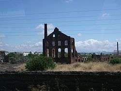
Buildings of former mining operations | ||
| ||
 Peñarroya-Pueblonuevo Location in Spain | ||
| Coordinates: 38°18′N 5°16′W / 38.300°N 5.267°W | ||
| Country | Spain | |
| Province | Córdoba | |
| Comarca | Valle del Guadiato | |
| Area | ||
| • Total | 63 km2 (24 sq mi) | |
| Elevation | 537 m (1,762 ft) | |
| Population (2006) | ||
| • Total | 12,050 | |
| • Density | 191.3/km2 (495/sq mi) | |
| Time zone | CET (UTC+1) | |
| • Summer (DST) | CEST (UTC+2) | |
Peñarroya-Pueblonuevo is a Municipality located in the province of Córdoba, Spain. According to the 2014 census,[1] the municipality has a population of 385 inhabitants. Its postal code is 14200.
It is a mining town located in the Sierra Morena, at the northern end of Córdoba Province near Extremadura.
History
The name of the present-day town originated in the merger of the towns of Peñarroya and Pueblonuevo del Terrible in 1927. The town of Pueblonuevo del Terrible had its name from a fierce dog that had lived there in the past and that had been nicknamed "Terrible".
The Battle of Peñarroya took place between 5 January and 4 February 1939 towards the end of the Spanish Civil War in the area of the town, which was located near the Extremaduran front line.[2]
See also
References
- ↑ Instituto Nacional de Estadística (INE)
- ↑ Antony Beevor. The Battle for Spain. The Spanish Civil War, 1936-1939. Penguin Books. 2006. London. p.375
External links
 Media related to Peñarroya-Pueblonuevo at Wikimedia Commons
- Peñarroya-Pueblonuevo - Sistema de Información Multiterritorial de Andalucía