Peak to Peak Highway
| |
|---|---|
| Route information | |
| Length: | 55 mi (89 km) |
| Existed: | 1918 – present |
| Major junctions | |
| South end: |
|
| North end: |
|
| Location | |
| Counties: | Gilpin, Boulder, Larimer |
| Highway system | |
|
Colorado State Highways
| |
The Peak to Peak Highway was established in 1918[1] and provides unmatched views of the Front Range Mountains in the Colorado Rocky Mountains. The route passes through the Colorado counties of Gilpin, Boulder, and Larimer.
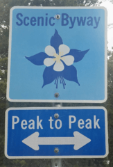
The route is classified as a scenic byway by the Colorado Department of Transportation (CDOT).[1] It was Colorado's first scenic roadway designation.

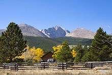
View on Peak to Peak Highway
40°11′19″N 105°29′55″W / 40.188742°N 105.498694°W
.jpg)
Aspen Trees on the Peak to Peak
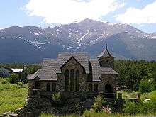
Chapel on the Rock (officially, Saint Catherine of Siena Chapel)
40°14′49″N 105°32′06″W / 40.246940°N 105.535127°W
Parks & Recreation Areas
- Rocky Mountain National Park
- Golden Gate Canyon State Park
- Arapaho National Forest
- Roosevelt National Forest
- Indian Peaks Wilderness Area
- Eldorado Canyon State Park
Mountains and Peaks
- Apache Peak
- Copeland Mountain
- Long's Peak
- McHenrys Peak
- Meadow Mountain
- Mt Audubon
- Mt Jasper
- Ogalalla Peak
References
- 1 2 Colorado Department of Transportation. "Peak To Peak". Colorado Department of Transportation.
External links
This article is issued from Wikipedia - version of the 7/2/2016. The text is available under the Creative Commons Attribution/Share Alike but additional terms may apply for the media files.