Peakshole Water
| Peakshole Water | |
|---|---|
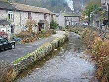 Autumnal view of Peakshole Water near Peak Cavern in Castleton | |
| Country | England |
| Basin | |
| Main source | Peak Cavern |
| River mouth | River Noe |
| Features | |
| Tributaries |
|
Peakshole Water is a stream in the Derbyshire Peak District named after its source, Peak Cavern. It flows through the village of Castleton to join the River Noe in nearby Hope. Despite its name, much of its flow actually emerges from the Russet Well, a resurgence in a garden on the east side of the gorge below the main Peak Cavern entrance, described as the "main resurgence of the Castleton area", which drains a series of swallets on the other side of the Pennine watershed below Rushup Edge. The resurgence has been explored by cave divers to a depth of 82 feet (25 m) but further exploration was halted by a constriction.[1]
The River Noe flows into the Derbyshire Derwent, which in turn leads to the River Trent and thence to the Humber estuary and the North Sea.
The stream once powered a corn mill in Castleton,[2] now disused and derelict. A public footpath leads from Castleton past the mill and follows close to the stream as far as Pindale Road south of Hope.[3] The stream has one main tributary, Odin Sitch, which rises above Odin Mine on the slopes of Mam Tor and joins Peakshole Water north of the visitor centre in Castleton.[4]
See also
References
- ↑ Barker, Iain; Beck, John S (2010). Caves of the Peak District (7th ed.). Derbyshire Caving Association. pp. 77, 126. ISBN 978-0-9563473-2-9.
- ↑ "Watermill, Castleton". The Mills Archive Trust. Retrieved 13 May 2016.
- ↑ Eardley, Denis. "Hope Walk". Discover Derbyshire and the Peak District. Retrieved 13 May 2016.
- ↑ OL1 Dark Peak area (Map). 1:25000. Explorer. Ordnance Survey.
Coordinates: 53°20′31″N 1°46′42″W / 53.34194°N 1.77833°W