Pelly Crossing
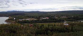
Pelly Crossing is a community in Yukon, Canada. It lies where the Klondike Highway crosses the Pelly River. Population in 2008 was 291.
It is the home of the Selkirk First Nation, and home to the Northern Tutchone culture. Cultural displays and artifacts are housed in a replica of Big Jonathan House. Visitors can make the journey from Minto by boat to visit the original structure down the Yukon River at Fort Selkirk, an important historic and cultural site for the Northern Tutchone people.
History
The Selkirk First Nation community was established as a ferry crossing and a highway construction camp when the Klondike Highway from Whitehorse to Dawson City was built in 1950. With the completion of the Pelly River bridge and the road to Dawson City, sternwheeler traffic on the Yukon River came to a halt. Fort Selkirk, located near the confluence of Pelly and Yukon Rivers, was virtually abandoned. The Selkirk First Nation moved from Fort Selkirk to Minto Landing before settling at Pelly Crossing. Today, the restored Fort Selkirk is a common stop for Yukon River travelers.
Geography
Pelly Crossing is located on the Pelly River, 155 miles south of Dawson City on the Klondike Highway.
Climate
| Climate data for Pelly Crossing | |||||||||||||
|---|---|---|---|---|---|---|---|---|---|---|---|---|---|
| Month | Jan | Feb | Mar | Apr | May | Jun | Jul | Aug | Sep | Oct | Nov | Dec | Year |
| Record high °C (°F) | 10 (50) |
12.2 (54) |
12.8 (55) |
23.5 (74.3) |
32.5 (90.5) |
35 (95) |
33 (91) |
33 (91) |
25.6 (78.1) |
20 (68) |
13.9 (57) |
12.8 (55) |
35 (95) |
| Average high °C (°F) | −22.2 (−8) |
−14 (7) |
−2 (28) |
8 (46) |
15.4 (59.7) |
20.9 (69.6) |
22.6 (72.7) |
20 (68) |
12.9 (55.2) |
1.8 (35.2) |
−11.7 (10.9) |
−19.2 (−2.6) |
2.7 (36.9) |
| Daily mean °C (°F) | −27.5 (−17.5) |
−21.1 (−6) |
−11.2 (11.8) |
0.5 (32.9) |
8 (46) |
13.4 (56.1) |
15.5 (59.9) |
12.7 (54.9) |
6.5 (43.7) |
−2.7 (27.1) |
−16.1 (3) |
−24.4 (−11.9) |
−3.9 (25) |
| Average low °C (°F) | −32.8 (−27) |
−28.1 (−18.6) |
−20.3 (−4.5) |
−7 (19) |
0.6 (33.1) |
5.9 (42.6) |
8.3 (46.9) |
5.5 (41.9) |
0 (32) |
−7.2 (19) |
−20.5 (−4.9) |
−29.6 (−21.3) |
−10.4 (13.3) |
| Record low °C (°F) | −58.9 (−74) |
−60 (−76) |
−50 (−58) |
−38.3 (−36.9) |
−12.2 (10) |
−3.5 (25.7) |
−2.8 (27) |
−7 (19) |
−20 (−4) |
−37 (−35) |
−51 (−60) |
−56.7 (−70.1) |
−60 (−76) |
| Average precipitation mm (inches) | 18.9 (0.744) |
14.4 (0.567) |
10.8 (0.425) |
11.1 (0.437) |
25 (0.98) |
38.2 (1.504) |
55.2 (2.173) |
39.5 (1.555) |
29.8 (1.173) |
24.8 (0.976) |
23.4 (0.921) |
19.3 (0.76) |
310.3 (12.217) |
| Source: Environment Canada[1] | |||||||||||||
Community
The local community is based on hunting, trapping, fishing and guiding. There is a school, curling rink, baseball field, swimming pool, church, youth center and laundromat. Visitor services include food, gas and lodging. There is one motel, take-out food, a grocery store, gas and diesel, minor vehicle repairs, a campground, post office and bank. Wild Things Harvest, featuring wild edibles from the Bush, is located south of town.
Sports
Every February, Pelly Crossing hosts a checkpoint for the long-distance Yukon Quest sled dog race.
References
| Wikimedia Commons has media related to Pelly Crossing. |
- ↑ Environment Canada Canadian Climate Normals 1971–2000, accessed 9 July 2010
| Regions | |
|---|---|
| Municipalities | |
| Communities | |
| Ghost towns | |
| Parks | |
| |
Coordinates: 62°50′N 136°35′W / 62.833°N 136.583°W