Pennsylvania Route 295
| ||||
|---|---|---|---|---|
 | ||||
| Route information | ||||
| Maintained by PennDOT and Conewago Township | ||||
| Length: | 6.287 mi[1] (10.118 km) | |||
| Existed: | 1961 – present | |||
| Major junctions | ||||
| South end: |
| |||
|
| ||||
| North end: |
| |||
| Location | ||||
| Counties: | York | |||
| Highway system | ||||
| ||||

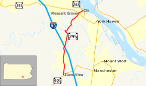
Pennsylvania Route 295 (PA 295) is a 6-mile-long (9.7 km) state highway located in York County, Pennsylvania. The southern terminus is at PA 921 in Zions View. The northern terminus is at PA 262 in Cly. PA 295 is a two-lane undivided road in the northern section of York County. The route heads north along Susquehanna Trail a short distance to the west of Interstate 83 (I-83) before reaching an interchange with the highway and heading to the east of it. PA 295 turns northeast in Strinestown and crosses PA 382 before it comes to its northern terminus.
The portion of PA 295 along the Susquehanna Trail became a part of the namesake auto trail in 1920. The Susquehanna Trail was designated as PA 4 in 1924 and also as U.S. Route 111 (US 111) in 1926; the PA 4 designation was removed from US 111 in 1928. The section of the present route north of Strinestown was paved in the 1930s. US 111 was moved off the Susquehanna Trail and onto I-83 in the 1950s. PA 295 was designated into the 1960s onto its current alignment.
Route description
PA 295 begins at an intersection with PA 921 in the community of Zions View in Conewago Township, heading north on two-lane undivided Susquehanna Trail. The road passes through rural residential areas before heading through a mix of farmland and homes. The route passes businesses as it comes to an interchange with I-83. From here, PA 295 passes residences in the community of Strinestown before running through a mix of woods and homes. The road turns northwest to descend a wooded bluff overlooking the Conewago Creek, crossing the creek into Newberry Township. Immediately after the creek, the route turns east onto Cragmoor Road, curving to the northeast a short distance later. PA 295 passes a few homes before running through a patch of farmland. The road enters forested areas with residences as it continues to the community of Pleasant Grove. Here, the route turns northwest onto Pleasant Grove Road briefly, passing industrial buildings before turning northeast onto Reesers Hill Road and reaching an intersection with PA 382. After this, PA 295 descends a wooded bluff with some homes and comes to its northern terminus at PA 262 in the community of Cly on the Susquehanna River.[2][3]
History
When Pennsylvania legislated routes in 1911, the portion of present-day PA 295 along Susquehanna Trail and Old Trail Road became part of Legislative Route 250, which ran between York and the Harrisburg area.[4] In 1920, this section of road became part of the Susquehanna Trail, an auto trail running between Baltimore and Williamsport, Pennsylvania.[5] The Susquehanna Trail was designated as PA 4 in 1924.[6][7] With the creation of the U.S. Highway System in 1926, US 111 became concurrent with PA 4 on the Susquehanna Trail, which was paved.[7][8] By 1926, Cragmoor Road, Pleasant Grove Road, and Reesers Hill Road were unnumbered, unpaved roads.[9] The concurrent PA 4 designation was removed from US 111 in 1928.[10][11][12] The section of present-day PA 295 north of US 111 in Strinestown was paved in the 1930s.[13] US 111 was realigned off Susquehanna Trail and Old Trail Road onto I-83 in the 1950s.[14] PA 295 was designated in the 1960s to run along its present alignment from PA 921 in Zions View north to PA 262 in Cly, with an interchange at I-83.[15]
Major intersections
The entire route is in York County.
| Location | mi[1] | km | Destinations | Notes | |
|---|---|---|---|---|---|
| Conewago Township | 0.000 | 0.000 | |||
| 2.520 | 4.056 | Exit 28 (I-83) | |||
| Newberry Township | 5.880 | 9.463 | |||
| 6.287 | 10.118 | ||||
| 1.000 mi = 1.609 km; 1.000 km = 0.621 mi | |||||
See also
 U.S. Roads portal
 Pennsylvania portal
References
- 1 2 "Pennsylvania state roads". Pennsylvania Spatial Data Access. Pennsylvania Department of Transportation. 2013. Retrieved March 14, 2013.
- ↑ Google (February 23, 2011). "overview of Pennsylvania Route 295" (Map). Google Maps. Google. Retrieved February 23, 2011.
- ↑ York County, Pennsylvania Highway Map (PDF) (Map). PennDOT. 2011. Retrieved February 22, 2011.
- ↑ Map of Pennsylvania Showing State Highways (PDF) (Map). Pennsylvania Department of Highways. 1911. Retrieved January 1, 2014.
- ↑ Smith, Stephen H. (October 30, 2015). "Halloween on the Susquehanna Trail". York Daily Record. Retrieved December 5, 2015.
- ↑ "William Penn Highway: US 22 in Pennsylvania". Federal Highway Administration. Retrieved 2007-06-26.
- 1 2 Pennsylvania Highway Map (eastern side) (Map). Gulf Oil. 1926. Retrieved December 26, 2007.
- ↑ Bureau of Public Roads & American Association of State Highway Officials (November 11, 1926). United States System of Highways Adopted for Uniform Marking by the American Association of State Highway Officials (Map). 1:7,000,000. Washington, DC: U.S. Geological Survey. OCLC 32889555. Retrieved November 7, 2013 – via University of North Texas Libraries.
- ↑ Map of the Public Roads in York County, Pennsylvania (PDF) (Map). Pennsylvania Department of Highways. 1926. Retrieved December 2, 2015.
- ↑ "U.S. Numbers For State Highways". Harrisburg Telegraph. January 20, 1928. p. 20. Retrieved August 31, 2015 – via Newspapers.com.

- ↑ "New Numbering System Prepared For Pa. Highways". Warren Tribune. January 28, 1928. p. 7. Retrieved August 31, 2015 – via Newspapers.com.
- ↑ Map of Pennsylvania (Map). Pennsylvania Department of Highways. 1928. Retrieved August 31, 2015.
- ↑ Official Road Map of Pennsylvania (PDF) (Map). Pennsylvania Department of Highways. 1940. Retrieved December 16, 2014.
- ↑ Official Map of Pennsylvania (PDF) (Map). Pennsylvania Department of Highways. 1960. Retrieved December 17, 2014.
- ↑ Official Map of Pennsylvania (PDF) (Map). Pennsylvania Department of Highways. 1970. Retrieved December 17, 2014.