Interstate 83
| |||||||
|---|---|---|---|---|---|---|---|
 | |||||||
| Route information | |||||||
| Maintained by Baltimore DOT, MDSHA, PennDOT | |||||||
| Length: | 85.3 mi[1] (137.3 km) | ||||||
| Existed: | 1959 – present | ||||||
| Major junctions | |||||||
| South end: | East Fayette Street / North President Street / Fallsway in Baltimore, MD | ||||||
|
| |||||||
| North end: |
| ||||||
| Location | |||||||
| States: | Maryland, Pennsylvania | ||||||
| Counties: |
MD: City of Baltimore, Baltimore PA: York, Cumberland, Dauphin | ||||||
| Highway system | |||||||
| |||||||

Interstate 83 (abbreviated I-83) is an Interstate Highway in the Eastern United States. Its southern terminus is in Baltimore, Maryland at a signalized intersection with Fayette Street; its northern terminus is in Harrisburg, Pennsylvania at I-81.
Most of the route south of Lemoyne, Pennsylvania is a direct replacement of U.S. Route 111 (US 111), a former spur of US 11.
Route description
| mi[1] | km | |
|---|---|---|
| MD | 34.5 | 55.5 |
| PA | 50.8 | 81.8 |
| Total | 85.3 | 137.3 |
Maryland
Jones Falls Expressway

The Jones Falls Expressway, known to local residents as the JFX, is a 10.2-mile-long (16.4 km) freeway that carries I-83 from downtown Baltimore to the northern suburbs. It is the area's true north–south artery, because I-95 runs mostly east–west through much of the city. Its southern terminus is at Fayette Street, and its northern terminus is at Maryland Route 25 (MD 25), just north of the Baltimore Beltway (I-695). Inside Baltimore, the road is maintained not by the Maryland State Highway Administration, which controls most freeways in the state, but by the city's Department of Transportation.
The freeway begins at an at-grade four-way intersection between the Jones Falls Expressway, Fayette Street, and President Street, located in close proximity to the Phoenix Shot Tower. President Street continues south along the eastern edge of the central business district (CBD) to terminate at a traffic circle in Harbor East. Fayette Street serves as an access route into the downtown area.
Passing beneath the Orleans Street Viaduct (part of US 40), the JFX runs north, passing near the Washington Monument. Between Exits 3 and 4, there is a 90-degree turn that sometimes requires motorists to slow down just before entering it. The curve is located between the Guilford Avenue and Preston Street overpasses. Within the curve, the southbound JFX interchanges with MD 2.

Having passed this curve, the JFX begins to parallel MD 25, interchanging with North Avenue (which carries US 1 and US 40 Truck) before continuing north past Druid Lake, forming the northeastern boundary of Druid Hill Park. Running northwest out of the city center, the JFX is paralleled by its namesake river, the Jones Falls, on one side, and the Baltimore Light Rail system on the other. Closer to downtown, the light rail line peels off in a different direction, while the Falls flows directly underneath the elevated freeway.
After interchanging with Cold Spring Lane and Northern Parkway (between which lies the Cylburn Arboretum), the JFX exits Baltimore, entering Baltimore County. Passing close to Mt. Washington Pediatric Hospital, Mount Saint Agnes College, and Jones Falls Park, the route skirts the edge of Robert E. Lee Park before interchanging with Ruxton Road just south of the Baltimore Beltway.
At the Beltway, I-83 leaves the JFX and joins I-695 for a distance of 1.4 miles (2.3 km), where it separates from the latter route to continue onward into northern Maryland. Meanwhile, the JFX continues for another 0.5 miles (0.80 km) in a four-lane divided format before terminating at an at-grade intersection with MD 25 Falls Road. I-83 and I-695 split off at the southern terminus of the Baltimore-Harrisburg Expressway, and I-695 continues its eastward trek towards Towson and Parkville.
Baltimore-Harrisburg Expressway
After separating from the Beltway, I-83 is now known as the Baltimore-Harrisburg Expressway. Running due north away from the Beltway, the route parallels MD 45 York Road, the former route of US 111. Passing to the west of Timonium and Cockeysville, I-83 leaves the suburban belt around Baltimore and enters rural Baltimore County just north of Hunt Valley at Shawan Road. I-83 and MD 45 continue to parallel one another through the northern portion of the county, with MD 45 crossing over I-83 once, at an interchange. This segment of I-83 has several sections with higher than usual gradients.
The only major settlement encountered by I-83 along this stretch is Monkton, reached via MD 137. To the west of I-83, MD 137 connects with the northern terminus of MD 25, I-83's former companion to the south.
The Interstate eventually crosses the Mason–Dixon line into York County, Pennsylvania, 25 miles (40 km) north of Baltimore, mere feet from a partial interchange with Freeland Road and parallel with MD 45; the latter route becomes the Susquehanna Trail when it reaches Pennsylvania.
Pennsylvania

Throughout Pennsylvania, I-83 is named the Veterans of Foreign Wars of the United States Memorial Highway.[2] I-83 enters Pennsylvania crossing the Mason-Dixon line and passing to the east of Shrewsbury, and runs due north towards York. The route bypasses the boroughs of Loganville and Jacobus before entering the city of York.
I-83 has a business route through downtown York, known as Interstate 83 Business. The business route follows the former path of US 111, while I-83 turns northeast and then north again to bypass the urban area. Near Pennsylvania Route 462 (PA 462), the Lincoln Highway, the interstate turns west for a short distance, then north again to interchange with US 30. Beyond US 30, I-83 resumes its straight path, running due north out of York and passing to the west of Emigsville.
North of Pennsylvania Route 295, I-83 is known as the Susquehanna Expressway. It maintains this name as it passes to the south and west of Valley Green, continuing north towards Harrisburg. South of Harrisburg, I-83 interchanges with I-76, the Pennsylvania Turnpike. North of I-76, I-83 continues due north, passing through New Cumberland, before an interchange with PA 581 in Lemoyne.
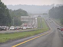
After the interchange with PA 581, I-83 is known as the Capital Beltway. The highway turns due east and crosses the Susquehanna River over the John Harris Bridge, south of Harrisburg's central business district, passing through Paxtang before encountering I-283 and US 322 at the Eisenhower Interchange. Within the interchange, I-83 exits from itself, with each direction of traffic following a one-lane ramp; facing east, I-83's former lanes become US 322, while, facing north, I-283's lanes become I-83. The interchanges includes ramps to local city streets as well. From this point northbound to exit 51 traffic is often congested during daylight hours. I-83 and westbound US 322 continue north toward US 22 and I-81, I-283 goes due south toward the turnpike and PA 283's western terminus, and eastbound US 322 goes due east toward Hershey.
Beyond this interchange, I-83 runs due north again through eastern Harrisburg, interchanging with US 22 northeast of the central business district, before terminating at a three-way semi-directional interchange with I-81.[3]
History
Jones Falls Expressway
The first Interstate to be built in Baltimore was the Jones Falls Expressway (JFX); the Greater Baltimore Committee pushed to enact legislation from the Baltimore City Council in 1955.[4] It was the first to be constructed due to community opposition to the other planned freeways within the city. By the early 1960s, the JFX was completed as far as Guilford Avenue, within the city limits. It was completed as far as Pleasant Street in the downtown area by 1983, but the remaining 4.4 miles (7.1 km) to I-95 were cancelled in September 1982. To compensate for the loss of the remainder of the JFX, the portion in situ was extended to Fayette Street by 1987, and the Jones Falls Boulevard project substantially rebuilt 0.75 miles (1.21 km) of President Street, across from the JFX at Fayette Street, to allow the traffic to and from the Interstate to be collected and distributed from the surrounding city streets. By 1990, the project was completed.
Due to community opposition to the other freeway plans being produced by city officials, the JFX was the very first limited-access highway to be completed within the city of Baltimore, and remained so for several years. Originally, the JFX was to continue through the Southeast Baltimore neighborhoods of Fells Point[5] and Canton to a junction with the then-planned I-95, but opposition from residents of those neighborhoods successfully blocked that proposal.[6]
Planning
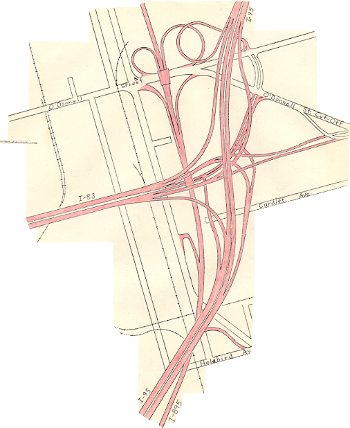
As part of the planning for an east–west route through Baltimore, the alignment of the JFX underwent various modifications. Under the original plan for freeways in Baltimore, the 1962 Baltimore 10-D Interstate System, the JFX would have junctioned I-70N (which became I-70 in 1975) and I-95, which were planned to follow an east–west route through the southern edge of the central business district (CBD), near the southeastern edge of the CBD. The JFX would end at roughly the same location where it currently does.[7] As a result of community opposition to other portions of the 10-D System, the 1969 Baltimore 3-A Interstate and Boulevard System was adopted by the city. In this plan, the JFX would continue south along its present alignment, then turn east and pass through the Fells Point neighborhood on a 6-lane elevated viaduct, before continuing east along Boston Street to junction I-95 (which was also rerouted to its current alignment) north of the Fort McHenry Tunnel. In the mid-1970s, this plan was modified due to fears that the viaduct would result in destruction of the Fells Point area, which contains many historic properties. Under the modification, I-83 would continue south and descend into a 6-lane underwater tunnel beneath the Inner Harbor, then turn east under the Harbor, pass to the south of Fells Point, return to the surface in the Canton area and continue to I-95.[8]
Under this plan, I-83 was expected to act mostly as a northerly spur to and from the CBD, and as an easterly spur to and from the CBD; through traffic was expected to be a small proportion of the total amount making use of the route. I-83's terminus at I-95 would have been a full 3-way freeway-to-freeway interchange, with a full complement of ramps provided for access to and from Boston Street and O'Donnell Street.[9] When construction began on I-95 through East Baltimore in the mid-1970s, a short six-lane section was built within the vicinity of the planned I-83 interchange. This was done in anticipation of I-83 connecting the CBD to I-95, the rest of which carries at least eight lanes of traffic throughout the city.
Truncation
By 1963 the JFX was completed as far south as Guilford Avenue, and by the mid-1970s, was extended to Monument Street. By 1983 the route extended all the way to Pleasant St, with a dead-end bridge stub indicating plans to continue south along the 3-A alignment to I-95.
However, in September 1982 the segment of the JFX between Pleasant Street and I-95, a distance of 4.4 miles (7.1 km), was officially withdrawn from the Interstate Highway System. Robert Douglas, chief of the Interstate Division for Baltimore City (IDBC), stated at the time that the very high financial costs of the I-83 extension (estimated at $609 million in early 1980s dollars, and likely to reach $1 billion with inflation taken into account) led to the cancellation of the segment. As a result, the JFX was truncated at Fayette Street, ending at an at-grade intersection.[10]
To make up for the loss of the I-83 segment, the Jones Falls Boulevard project substantially rebuilt approximately 0.5 miles (0.80 km) of President Street between I-83 and the downtown area to provide the capacity to absorb traffic to and from the Interstate; the project was completed by 1987. Other roadways in the canceled I-83 corridor also benefited from major reconstruction and rehabilitation.[10] The federal funding planned to be used for the I-83 extension was instead cross-transferred to other highway projects; routes that may have benefited include I-97, I-195, I-370, and the upgrade of John Hanson Highway to I-595.
Future
As Congress worked toward reauthorization of the Surface Transportation Act, the Greater Lynchburg Chamber of Commerce and other groups in Virginia wanted I-83 extended southward to provide bypasses for Charlottesville, Lynchburg, and Danville, and to link those cities to Greensboro, North Carolina. By June 1991, Robert LaLone, director of programs for the Lynchburg Chamber, admitted that an interstate was unlikely, but upgrading of US 29, with bypasses included, is more likely.[11]
The possibility of extending I-83 (rather than I-99) north to Rochester, New York was discussed at the October 2002 I-99 Task Force meeting. However, part of the proposed route on US 11 / US 15 has since been rebuilt as a four-lane surface road that does not meet Interstate standards.[12] Expensive additional reconstruction, including new interchanges, service roads and realignments, would be necessary. The farthest north that I-83 could be extended currently would be Benvenue, Pennsylvania on a bridge over the Susquehanna River, where a recently built freeway section of U.S. Route 22 / US 322 (the Dauphin Bypass) downgrades to an undivided four-lane road.
In 2005, Walter Sondheim, a prominent Baltimore city planner unveiled a proposal to tear down the elevated portion of the JFX that leads into downtown. In the JFX's place, President Street would be extended north to Eager Street, where the elevated section ends. City officials have since offered tentative support for the idea, though it is unlikely that any action will be taken until about 2020, when the current elevated structure will need an overhaul if it is to remain in use. If the downtown JFX were demolished, Baltimore would join San Francisco, Boston and Milwaukee to become among the large American cities that have removed some of their downtown elevated freeways. On May 17, 2009, the Baltimore Sun revealed a plan by Rummel, Klepper & Kahl LLP, to tear down a mile of the Jones Falls Expressway to create an urban boulevard that would help connect downtown to the east side of the city, and Johns Hopkins Hospital.[13]
From 2012 to 2015, the I-83 / PA 581 interchange was modified. Formerly, I-83 was reduced to one lane going northbound through the interchange, resulting in frequent traffic jams during peak travel times. The northbound part of the highway was widened, one bridge was replaced and several exits in the vicinity were reconfigured.[14]
Exit list
| State | County | Location | mi [15][16][17] | km | Old exit [18] | New exit [18] | Destinations | Notes |
|---|---|---|---|---|---|---|---|---|
| Maryland | Baltimore City | 0.00 | 0.00 | 1 | President Street south / Fayette Street | Southern terminus; at-grade intersection | ||
| 0.30 | 0.48 | 2 | Pleasant Street | Southbound exit only | ||||
| 0.90 | 1.45 | 3 | Chase Street | Northbound exit only | ||||
| 0.90 | 1.45 | 3 | Guilford Avenue | Southbound exit only | ||||
| 1.29 | 2.08 | 4 | Southbound exit only | |||||
| 1.51 | 2.43 | 5 | Maryland Avenue | Southbound exit, northbound entrance | ||||
| 1.85 | 2.98 | 6 | No entrance from southbound US 1 to southbound I-83 | |||||
| 2.42 | 3.89 | 7 | 28th Street / Druid Park Lake Drive | Split into exits 7A (Druid Park Lake Drive) and 7B (28th Street) northbound | ||||
| 3.02 | 4.86 | 8 | Northbound exit, southbound entrance | |||||
| 4.74 | 7.63 | 9 | Cold Spring Lane | Split into exits 9A (east) and 9B (west) | ||||
| 5.86 | 9.43 | 10 | Northern Parkway | Split into exits 10A (east) and 10B (west) | ||||
| Baltimore | Ruxton | 8.97 | 14.44 | 12 | Ruxton Road / To | Northbound exit, southbound entrance | ||
| Brooklandville | 9.74 | 15.68 | 23 | No exit number northbound; signed as I-695 Exit 23 southbound; south end of concurrency with I-695; connector north to MD 25 is unsigned MD 25A | ||||
| Lutherville | 11.26 | 18.12 | 24 | No exit number southbound; signed as I-695 Exit 24 northbound; north end of concurrency with I-695 | ||||
| Timonium | 12.59 | 20.26 | 16 | Timonium Road | Split into exits 16A (east) and 16B (west) northbound | |||
| 14.02 | 22.56 | 17 | Padonia Road | |||||
| Cockeysville | 15.44 | 24.85 | 18 | Warren Road – Cockeysville | Northbound exit, southbound entrance; Warren Road is unsigned MD 943 | |||
| 17.18 | 27.65 | 20 | Shawan Road – Cockeysville | Split into exits 20A (east) and 20B (west) | ||||
| Sparks | 20.97 | 33.75 | 24 | Belfast Road – Butler, Sparks | ||||
| Hereford | 24.26 | 39.04 | 27 | |||||
| Parkton | 27.61 | 44.43 | 31 | Middletown Road – Parkton | ||||
| 29.63 | 47.68 | 33 | ||||||
| Maryland Line | 33.22 | 53.46 | 36 | |||||
| 34.35 | 55.28 | 37 | Freeland Road | Southbound exit, northbound entrance | ||||
| Mason–Dixon line | 34.50 0.000 | 55.52 0.000 | Maryland–Pennsylvania state line | |||||
| Pennsylvania | York | Shrewsbury Township | 3.529 | 5.679 | 1 | 4 | ||
| Springfield Township | 7.529 | 12.117 | 2 | 8 | ||||
| 10.340 | 16.641 | 3 | 10 | |||||
| Spring Garden Township | 13.657 | 21.979 | 4 | 14 | ||||
| 14.230 | 22.901 | 5 | 15 | Directional T interchange | ||||
| 15.497 | 24.940 | 6 | 16 | Split into exits 16A (south) and 16B (north) | ||||
| 17.600 | 28.324 | 7 | 18 | |||||
| Springettsbury Township | 18.746 | 30.169 | 8 | 19 | Split into exits 19A (east) and 19B (west) southbound | |||
| Manchester Township | 21.071 | 33.910 | 9 | 21 | Split into exits 21A (east) and 21B (west) northbound; no access from southbound I-83 to westbound US 30 or from eastbound US 30 to northbound I-83 | |||
| 21.648 | 34.839 | 10 | 22 | |||||
| 23.716 | 38.167 | 11 | 24 | |||||
| 28.152 | 45.306 | 12 | 28 | |||||
| Newberry Township | 31.932 | 51.390 | 13 | 32 | ||||
| 33.374 | 53.710 | 14 | 33 | |||||
| Fairview Township | 33.874 | 54.515 | 14A | 34 | Valley Green | Northbound exit and entrance | ||
| 34.991 | 56.313 | 15 | 35 | |||||
| 35.904 | 57.782 | 16 | 36 | |||||
| 37.893 | 60.983 | 17 | 38 | Evergreen Road / Pleasant View Road – Reesers Summit | ||||
| 38.775 | 62.402 | 18 | 39A | |||||
| 39.055 | 62.853 | 39B | I-76 / Penna Turnpike Exit 242 (Harrisburg West) | |||||
| 39.246 | 63.160 | 18A | 40A | Limekiln Road | ||||
| Cumberland | Lower Allen Township | 40.499 | 65.177 | 19 | 40B | Carlisle Road – New Cumberland | ||
| Lemoyne | 41.193 | 66.294 | 20 | 41A | Trumpet interchange; I-83 uses trumpet ramps through interchange | |||
| 41.438 | 66.688 | 21- 22 | 41B | Lowther Street – Lemoyne, Highland Park | Northbound exit south of PA 581; northbound entrance and southbound exit and entrance east of PA 581 | |||
| Susquehanna River | 42.006– 42.636 | 67.602– 68.616 | John Harris Bridge | |||||
| Dauphin | Harrisburg | 42.671 | 68.672 | 23 | 43 | 2nd Street – Capitol | Directional T interchange | |
| 43.149 | 69.442 | 24 | 44A | |||||
| 43.450 | 69.926 | 25 | 44B | 17th Street | Southbound exit and entrance | |||
| 43.653 | 70.253 | 25 | 44B | 19th Street | Northbound exit and entrance | |||
| 44.658 | 71.870 | 26 | 45 | Paxton Street | Northbound exit and entrance, access via 32nd Street | |||
| 45.512 | 73.244 | 26 | 45 | Paxton Street / Bass Pro Drive | Southbound exit and entrance | |||
| Swatara Township | 45.927 | 73.912 | 28 | 46 | I-283 Exits 3A-B; Eisenhower Interchange; split into exits 46A (I-283) and 46B (US 322) northbound. | |||
| 46.852 | 75.401 | 27- 28 | 47 | Southbound exit, northbound entrance; south end of concurrency with US 322 | ||||
| Lower Paxton Township | 47.940 | 77.152 | 29 | 48 | Union Deposit Road | |||
| 49.220 | 79.212 | 30 | 50 | Split into exits 50A (east) and 50B (west) northbound | ||||
| 50.688 | 81.574 | 51A | Northern terminus; I-81 Exit 70; North end of US 322 concurrency. | |||||
| 50.688 | 81.574 | 51B | ||||||
1.000 mi = 1.609 km; 1.000 km = 0.621 mi
| ||||||||
Auxiliary routes
I-83 has only one spur route: I-283, a connector to I-76 and PA 283 southeast of Harrisburg.
Business routes
Business loop of York, Pennsylvania
| |
|---|---|
| Location: | York, Pennsylvania |
| Existed: | 1957–present |
Interstate 83 Business (I-83 Bus.) is a short Interstate business loop in York, Pennsylvania. Its northern terminus is at I-83 and PA 181 north of York. Its southern terminus is at I-83, south of York. The road is known as George Street for much of its length. It was the only Interstate business route in the entire state of Pennsylvania until 2009, when Pennsylvania Route 60 near Pittsburgh, was resigned as an extension of Interstate 376; PA 60's business loop was likewise resigned as a business loop of I-376[19]
Major intersections
The entire route is in York County.
| Location | mi | km | Destinations | Notes | |
|---|---|---|---|---|---|
| York Township | 0.00 | 0.00 | I-83 exit 15 | ||
| York | South George Street | Southbound exit and northbound entrance | |||
| 4.73 | 7.61 | ||||
| 4.88 | 7.85 | ||||
| Manchester Township | 6.35 | 10.22 | South end of PA 181 overlap | ||
| 6.81 | 10.96 | I-83 exit 22 | |||
1.000 mi = 1.609 km; 1.000 km = 0.621 mi
| |||||
See also
 U.S. Roads portal
 Maryland Roads portal
 Pennsylvania portal
References
- 1 2 "Route Log and Finder List — Interstate System: Table 1". FHWA. Retrieved 2008-02-18.
- ↑ http://www.palrb.us/pamphletlaws/19001999/1984/0/act/0155.pdf
- ↑ Google (2011-03-08). "Interstate 83 in Pennsylvania" (Map). Google Maps. Google. Retrieved 2011-03-08.
- ↑ "First Birthday Of The Greater Baltimore Committee". The Baltimore Sun. 6 January 1956.
- ↑ "Fells Point Case". The Baltimore Sun. December 20, 1970. p. K4.
- ↑ "The End of 1-83". The Baltimore Sun. March 18, 1983. p. A20.
- ↑ Kozel, Scott. Roads to the Future: Baltimore Early Expressway Planning URL accessed 11:38, 13 February 2007.
- ↑ Kozel, Scott. Roads to the Future: Baltimore City Interstates URL accessed 11:42, 13 February 2007.
- ↑ Scale diagram of I-83/I-95 interchange in Baltimore City
- 1 2 Kozel, Scott. misc.transport.road: Baltimore Interstate Highway Cancellation Details URL accessed 11:52, 13 February 2007.
- ↑ Scism, Jack. "New Interstates Likely Impossible Dream." Greensboro News & Record, June 9, 1991.
- ↑ "Aaroads - Corridor 9". Retrieved 4 October 2014.
- ↑ "Baltimore Looks Into Scrapping Mile-long Stretch Of Jfx To Help Revive East Side". baltimoresun.com. Retrieved 14 June 2014.
- ↑ "I-83/PA 581 Interchange Bottleneck Safety Project". i83beltway.com. Retrieved 26 May 2013.
- ↑ Highway Information Services Division (December 31, 2005). Highway Location Reference. Maryland State Highway Administration. Retrieved 2013-09-02.
- Baltimore City (PDF)
- ↑ Highway Information Services Division (December 31, 2013). Highway Location Reference. Maryland State Highway Administration. Retrieved 2013-09-02.
- Baltimore County (PDF)
- ↑ Bureau of Maintenance and Operations (January 2015). Roadway Management System Straight Line Diagrams (Report) (2015 ed.). Pennsylvania Department of Transportation. Retrieved June 30, 2015.
- York County (PDF)
- Cumberland County (PDF)
- Dauphin County (PDF)
- 1 2 "Pennsylvania Exit Numbering" (PDF). Pennsylvania Department of Transportation. Retrieved October 2, 2007.
- ↑ Pennsylvania Highways: PA 51 - 100
External links
| Wikimedia Commons has media related to Interstate 83. |
- AARoads.com article on I-83
- I-83 @ MDRoads.com
- Interstate Guide - I-83
- Maryland Multiplexes - I-83/I-695 Duplex
- Pennsylvania Multiplexes - I-83/US 322 Duplex
- Steve Anderson's DCroads.net: Baltimore-Harrisburg Expressway (I-83)
- Steve Anderson's DCroads.net: Jones Falls Expressway (I-83)
- Roads to the Future: Baltimore Harbor Interstate Map
- Kelly, Jacques. "JFX is a long stretch of history," The Baltimore Sun, Saturday, February 7, 2009.
| Signed | |||||||||||
|---|---|---|---|---|---|---|---|---|---|---|---|
| Unsigned | |||||||||||
| Lists |
| ||||||||||
Major Interstates highlighted | |||||||||||