Pennsylvania Route 299
| ||||
|---|---|---|---|---|
| Powell Avenue | ||||
|
PA 299 highlighted in red; the route prior to 2011 is shown as a dotted red line | ||||
| Route information | ||||
| Maintained by PennDOT | ||||
| Length: | 0.052 mi[1] (0.084 km) | |||
| Existed: | 1930 – present | |||
| Major junctions | ||||
| South end: | Powell Avenue in Millcreek Township | |||
| North end: | Powell Avenue in Millcreek Township | |||
| Location | ||||
| Counties: | Erie | |||
| Highway system | ||||
| ||||

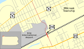
Pennsylvania Route 299 (PA 299) is a 0.05-mile-long (260 ft; 80 m) state highway located in Erie County in Pennsylvania. The route is the designation for the Staff Sergeant Jeremy R. Horton Memorial Bridge that carries Powell Avenue over two railroad lines in Millcreek Township. PA 299 was designated in 1930 between US 20 and PA 99, which is now PA 5 Alternate (PA 5 Alt.), running along Powell Avenue. In 2006, the current bridge over the railroad tracks was built. In 2011, all of PA 299 was decommissioned except for the Staff Sergeant Jeremy R. Horton Memorial Bridge. The section of Powell Avenue north of the bridge was realigned in 2012 as a result of runway expansion at Erie International Airport
Route description
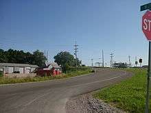
PA 299 begins at the south end of the Staff Sergeant Jeremy R. Horton Memorial Bridge in Millcreek Township, where the road continues south as locally maintained Powell Avenue to an intersection with US 20. The bridge runs past industrial areas before carrying the route over a Norfolk Southern railroad line followed by a CSX railroad line. At the north end of the bridge, the PA 299 designation ends and Powell Avenue continues north as a local road to Erie International Airport, where the road bypasses the runway to the east as 20th Street and Marshall Drive. Past the runway, Powell Avenue resumes at Oxer Road and intersects PA 5 (West 12th Street) and PA 5 Alternate (West Lake Road) before continuing several more blocks to the Lake Erie shoreline.[2][3][4][5]
History
When Pennsylvania legislated routes in 1911, what would become PA 299 was not given a number.[6] PA 299 was established in 1930 as a spur of PA 99 running south to US 20 on Powell Avenue. PA 99 ran on what is now PA 5 Alternate. Upon designation, the entire length of PA 299 was paved.[7] In 2006, the Powell Avenue Bridge was replaced with the Staff Sergeant Jeremy R. Horton Memorial Bridge.[4][8] In 2011, the entire length of PA 299 with the exception of the Staff Sergeant Jeremy R. Horton Memorial Bridge was removed from the state highway system.[3] Between 2010 and 2012, the runway at Erie International Airport was expanded, forcing Powell Avenue to be relocated around it.[9]
Major intersections
The entire route is in Millcreek Township, Erie County.
| mi[1] | km | Destinations | Notes | ||
|---|---|---|---|---|---|
| 0.000 | 0.000 | Powell Avenue south | |||
| 0.052 | 0.084 | Powell Avenue north | |||
| 1.000 mi = 1.609 km; 1.000 km = 0.621 mi | |||||
See also
 U.S. Roads portal
 Pennsylvania portal
References
- 1 2 Bureau of Maintenance and Operations (December 17, 2015). Roadway Management System Straight Line Diagrams (Report) (2015 ed.). Pennsylvania Department of Transportation. Retrieved August 31, 2016.
- Erie County (PDF)
- ↑ Google (July 28, 2011). "overview of Pennsylvania Route 299" (Map). Google Maps. Google. Retrieved July 28, 2011.
- 1 2 Erie County, Pennsylvania Highway Map (PDF) (Map). PennDOT. 2011. Retrieved June 4, 2011.
- 1 2 "Bridge to Carry Soldier's Name". Erie Times-News. January 25, 2008.
- ↑ "House Bill No 1795". General Assembly of Pennsylvania. 2007. Retrieved October 26, 2015.
- ↑ Map of Pennsylvania Showing State Highways (PDF) (Map). Pennsylvania Department of Highways. 1911. Retrieved January 1, 2014.
- ↑ Pennsylvania State Map (front side) (PDF) (Map). Pennsylvania Department of Highways. 1930. Retrieved 2007-09-12.
- ↑ "Powell Avenue Bridge to Be Replaced". PennDOT. January 23, 2006.
- ↑ Myers, Valerie (April 15, 2014). "Erie airport to pave old portion of runway this summer". Erie Times-News. Retrieved October 26, 2015.
External links
| Wikimedia Commons has media related to Pennsylvania Route 299. |