Pennsylvania Route 99
| |||||||
|---|---|---|---|---|---|---|---|
 | |||||||
| Route information | |||||||
| Maintained by PennDOT | |||||||
| Length: | 21.04 mi[1] (33.86 km) | ||||||
| Major junctions | |||||||
| South end: |
| ||||||
|
| |||||||
| North end: |
| ||||||
| Location | |||||||
| Counties: | Crawford, Erie | ||||||
| Highway system | |||||||
| |||||||

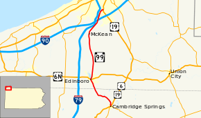
Pennsylvania Route 99 (PA 99), officially SR 699, is a 21-mile-long (34 km) state highway located in western Pennsylvania. The northern terminus is at U.S. Route 19 near Erie. The southern terminus is at US 6 and US 19 in Cambridge Springs.
Along its routing, PA 99 is known as Interchange Road, Edinboro Road, Main Street, Forest Street, Erie Street, Meadville Street, and McClellan Street.
It previously shared an official SR designation with Interstate 99 but was changed in 2008 to be officially SR 0699.[2]
Route description
PA 99 begins at an intersection with US 6/US 19 near the northern edge of Cambridge Springs. The route heads northwest, crossing Conneauttee Creek at Drakes Mills midway between Cambridge Springs and the Crawford-Erie county line. North of the county line, PA 99 crosses the creek once more and follows the waterway into Edinboro. Within the borough, PA 99 passes by Edinboro University of Pennsylvania south of an intersection with U.S. Route 6N in the center of the borough. The route continues northward, following the eastern edge of Edinboro Lake for a short distance.
Near McKean, PA 99 begins to parallel Interstate 79 as both roadways approach Erie. Midway between McKean and Erie, PA 99 passes over Interstate 90 east of its interchange with I-79. Just south of the city limits in the Millcreek Township community of Kearsarge, PA 99 separates from I-79 and turns east at a T-intersection to access US 19, where PA 99 terminates.
History
In 1928, the PA 99 number was first assigned to what is now Pennsylvania Route 5 along the shores of Lake Erie. Along its course, the highway had two spurs in the Erie Metropolitan Area: Pennsylvania Route 199 and Pennsylvania Route 299. The current alignment from Edinboro to Kearsarge was signed as U.S. Route 19.
By 1940, PA 99 was moved to its current alignment.[3][4]
Major intersections
| County | Location | mi[1] | km | Destinations | Notes |
|---|---|---|---|---|---|
| Crawford | Cambridge Springs | 0.00 | 0.00 | ||
| Erie | Edinboro | 6.88 | 11.07 | ||
| Millcreek Township | 21.04 | 33.86 | |||
| 1.000 mi = 1.609 km; 1.000 km = 0.621 mi | |||||
See also
 U.S. Roads portal
 Pennsylvania portal
References
- 1 2 DeLorme Street Atlas USA 2007 software, Toggle Measure Tool
- ↑ Erie County Type 10 Map (PDF) (Map). PennDOT. 2008. Retrieved 2009-01-06.
- ↑ Highway Map of Pennsylvania (front side) (PDF) (Map). Pennsylvania Department of Highways. 1930. Retrieved 2007-09-12.
- ↑ Highway Map of Pennsylvania (front side) (PDF) (Map). Pennsylvania Department of Highways. 1940. Retrieved 2007-09-12.