Pennsylvania Route 331
| ||||
|---|---|---|---|---|
|
PA 331 highlighted in red, former routing shown as dotted red line | ||||
| Route information | ||||
| Maintained by PennDOT | ||||
| Length: | 14.508 mi[1] (23.348 km) | |||
| Major junctions | ||||
| West end: |
| |||
|
| ||||
| East end: |
| |||
| Location | ||||
| Counties: | Washington | |||
| Highway system | ||||
| ||||

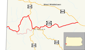
Pennsylvania Route 331 (PA 331) is a 14.5-mile-long (23.3 km), east–west state highway located in Washington County, Pennsylvania. The western terminus is at the West Virginia state line in Independence Township where the road continues as West Virginia Route 67. The eastern terminus is at PA 844 in Canton Township. PA 331 was initially established by the 1940s. The route was rerouted in the 2000s following the closure of a bridge over Buffalo Creek.
Route description
PA 331 begins at the West Virginia state border, at the eastern terminus of WV 67. The route heads east in Independence Township paralleling Buffalo Creek. After 1.8 miles (2.9 km), the route makes a left turn onto Mount Hope Ridge Road.[2] PA 231 meets PA 331 in the community of Mount Hope and together head south towards the community of Acheson. After turning east, PA 231 exits the concurrency and PA 331 alone heads east following the course of Brush Run. After passing through the southernmost portion of Hopewell Township, it reaches its eastern terminus at PA 844 in Canton Township.[2][3]
History
The route was established by 1940 on much of the same alignment it runs today.[4] Prior to 2005, PA 331 followed a more direct route between the state line and Acheson by following Buffalo Creek in Independence and Donegal Townships.[5] On August 30, 2005, the Pennsylvania Department of Transportation (PennDOT) closed and later removed one of the bridges over Buffalo Creek due to safety concerns.[6] By 2007, PA 331 was routed onto then-SR 4065 (Mount Hope Ridge Road) and PA 231 and the decommissioned sections of PA 331 became SR 3001, SR 4034, and SR 4036.[2][7]
Major intersections
The entire route is in Washington County.
| Location | mi[1] | km | Destinations | Notes | |
|---|---|---|---|---|---|
| Independence Township | 0.000 | 0.000 | West Virginia state line | ||
| 5.141 | 8.274 | Western terminus of PA 231 concurrency | |||
| 7.332 | 11.800 | Eastern terminus of PA 231 concurrency | |||
| Canton Township | 14.508 | 23.348 | |||
1.000 mi = 1.609 km; 1.000 km = 0.621 mi
| |||||
PA 331 Truck
| |
|---|---|
| Location: | Washington County, Pennsylvania |
Pennsylvania Route 331 Truck is a truck route bypassing a weight-restricted bridge over a branch over Brush Run on which trucks over 36 tons and combination loads over 40 tons are prohibited. The route was signed in 2013.
See also
 U.S. Roads portal
 Pennsylvania portal
References
- 1 2 Bureau of Maintenance and Operations (January 2015). Roadway Management System Straight Line Diagrams (Report) (2015 ed.). Pennsylvania Department of Transportation. Retrieved June 30, 2015.
- Washington County (PDF)
- 1 2 3 General Highway Map - Washington County, Pennsylvania (PDF) (Map). Pennsylvania Department of Transportation. 2012. Retrieved March 31, 2013.
- ↑ Google (March 31, 2013). "Pennsylvania Route 331" (Map). Google Maps. Google. Retrieved March 31, 2013.
- ↑ Official Road Map of Pennsylvania (PDF) (Map). Pennsylvania Department of Highways. 1940. Retrieved February 26, 2014.
- ↑ ftp://ftp.dot.state.pa.us/public/pdf/BPR_PDF_FILES/Maps/Type_10_GHS_Historical_Scans/Washington_1941_Sheet_2.pdf
- ↑ "PENNDOT closes bridge in Independence". Observer–Reporter. Washington, Pennsylvania. August 31, 2005. Retrieved March 31, 2013.
- ↑ ftp://ftp.dot.state.pa.us/public/pdf/BPR_PDF_FILES/MAPS/Statewide/otm/2007/otmsw_2007.PDF