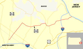
Pennsylvania Route 332
| ||||
|---|---|---|---|---|
 | ||||
| Route information | ||||
| Maintained by PennDOT | ||||
| Length: | 17.522 mi[1] (28.199 km) | |||
| Existed: | 1928[2] – present | |||
| Major junctions | ||||
| West end: |
| |||
|
| ||||
| East end: |
| |||
| Location | ||||
| Counties: | Montgomery, Bucks | |||
| Highway system | ||||
| ||||

Pennsylvania Route 332 (PA 332) is a state highway in the U.S. state of Pennsylvania. The route runs 17.5 miles (28.2 km) from PA 263 in Hatboro, Montgomery County east to PA 32 in Yardley, Bucks County. PA 332 runs through suburban areas to the north of Philadelphia, serving Warminster, Ivyland, Richboro, and Newtown. The route is two lanes wide most of its length, with the bypass around Newtown a four-lane divided highway. PA 332 intersects PA 132 in Warminster, PA 232 in Richboro, PA 413 and PA 532 in Newtown (all three run concurrently on the Newtown Bypass), and Interstate 95 (I-95) in Lower Makefield Township.
What would become PA 332 between Newtown and Yardley was designated part of Legislative Route 252 in 1911. PA 332 was created in 1928 to run from PA 263 in Hatboro east to Ivyland with the road between Newtown and Yardley designated as part of PA 532. By 1940, PA 332 was extended to PA 113 in Newtown. The route was extended to Yardley by 1947, replacing PA 532. PA 332 was routed to bypass Newtown in 1991 when the eastern portion of the Newtown Bypass was completed.
Route description
PA 332 begins at an intersection with PA 263 (York Road) in Hatboro, Montgomery County, heading east on Montgomery Avenue, a two-lane undivided roadway. The road passes through residential areas, crossing SEPTA's Warminster Line. Immediately after crossing the railroad tracks, the route turns northeast on Jacksonville Road and runs through industrial areas with some homes.[3][4]
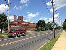
PA 332 intersects County Line Road and it enters Warminster Township in Bucks County, passing between the Warminster train station to the west and the neighborhood of Warminster Heights to the east. The route widens to four lanes and intersects PA 132 as it continues near industrial parks. The road narrows back to two lanes past the Johnsville Boulevard intersection and enters Ivyland, heading past homes. The route becomes the border between Ivyland to the northwest and Warminster Township to the southeast prior to crossing Bristol Road into Northampton Township. PA 332 continues between industrial areas to the northwest and residential areas to the southeast, reaching an intersection with Almshouse Road.[3][5]

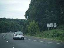
PA 332 turns southeast onto Almshouse Road and runs through a mix of farm fields and residences. Past the Hatboro Road intersection, the road curves to the east and gains a center left-turn lane, heading into Richboro. In Richboro, the route passes through business areas and intersects PA 232. Upon crossing PA 232, PA 332 changes its name to Newtown Richboro Road and continues past more homes as a two-lane road. The road forms the southern boundary of Tyler State Park, running between areas of fields and woods in the park to the north and residential subdivisions to the south. The route curves northeast and then east before crossing the Neshaminy Creek into Newtown Township. In this area, the road briefly widens into a divided highway before it comes to an intersection with PA 413 and PA 532 at the Newtown Bypass, a road that provides a bypass of the borough of Newtown.[3][5]
At this point, PA 332 turns south on the four-lane divided Newtown Bypass, forming a concurrency with PA 413 and PA 532. The road heads through wooded areas with nearby residential development, with PA 532 splitting southwest onto Buck Road toward Holland. PA 332 and PA 413 curve east and come to a bridge over the abandoned Fox Chase/Newtown railroad line, with PA 413 turning south onto Newtown Langhorne Road toward Langhorne. PA 332 continues east near residential and commercial development a short distance to the north of the border between Newtown Township and Middletown Township. The road curves to the northeast before turning east past the intersection with Newtown Yardley Road.[3][5]
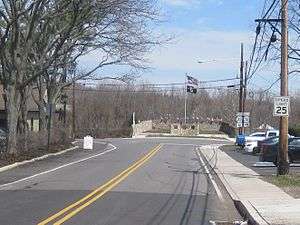
Upon intersecting Lindenhurst Road, the route enters Lower Makefield Township and becomes Newtown Yardley Road. It passes through farmland before heading north of an office park and reaching an interchange with I-95. Following this interchange, PA 332 becomes a two-lane undivided road and enters residential areas. The route turns northeast onto Yardley Langhorne Road and crosses into Yardley, where it is known as Afton Avenue. The road heads into the downtown area and crosses the Delaware Canal. PA 332 comes to its eastern terminus at an intersection with PA 32, which runs along the Delaware River.[3][5]
History
What would become PA 332 between Newtown and Yardley was designated as part of Legislative Route 252 in 1911, which continued southeast from Yardley to Morrisville.[6] In 1928, PA 332 was designated to run from PA 263 in Hatboro east to Ivyland, with the portion of road between Newtown and Yardley designated as part of PA 532. Between Ivyland and Newtown, the road remained an unnumbered road that was paved with the exception of a portion west of Newtown.[2] PA 332 was extended east to end at PA 113 (State Street) in Newtown by 1940, with the entire route paved by that time. PA 332 entered Newtown from the west on Newtown-Richboro Road.[7]
By 1947, PA 332 was extended east to Yardley, replacing that portion of PA 532. The route continued north from its previous eastern terminus on PA 413 (former PA 113, State Street) before turning east on Washington Street and leaving Newtown on Newtown Yardley Road.[8][9] The portion of the Newtown Bypass carrying PA 332 west of PA 413 (Newtown Langhorne Road) was completed as part of a western bypass of Newtown for PA 413 in 1977. In September 1989, construction began to extend the Newtown Bypass east to the interchange between PA 332 and I-95.[10] Construction on this bypass was completed in November 1991 at a cost of $16.6 million.[11] With the completion of this bypass, PA 332 was routed to bypass Newtown.[12]
Major intersections
| County | Location | mi[1] | km | Destinations | Notes |
|---|---|---|---|---|---|
| Montgomery | Hatboro | 0.000 | 0.000 | Western terminus | |
| Bucks | Warminster Township | 1.879 | 3.024 | ||
| Northampton Township | 7.036 | 11.323 | |||
| Newtown Township | 10.572 | 17.014 | West end of PA 413/PA 532 overlap | ||
| 11.154 | 17.951 | East end of PA 532 overlap | |||
| 11.820 | 19.022 | East end of PA 413 overlap | |||
| Lower Makefield Township | 14.849 | 23.897 | Exit 49 on I-95 | ||
| Yardley | 17.522 | 28.199 | Eastern terminus | ||
1.000 mi = 1.609 km; 1.000 km = 0.621 mi
| |||||
See also
 U.S. Roads portal
 Pennsylvania portal
References
- 1 2 Bureau of Maintenance and Operations (January 2015). Roadway Management System Straight Line Diagrams (Report) (2015 ed.). Pennsylvania Department of Transportation. Retrieved June 30, 2015.
- Montgomery County (PDF)
- Bucks County (PDF)
- 1 2 Map of Pennsylvania (Map). Pennsylvania Department of Highways. 1928. Retrieved May 7, 2015.
- 1 2 3 4 5 Google (January 4, 2012). "overview of Pennsylvania Route 332" (Map). Google Maps. Google. Retrieved January 4, 2012.
- ↑ Montgomery County, Pennsylvania (Map) (18th ed.). 1"=2000'. ADC Map. 2006. ISBN 0-87530-775-2.
- 1 2 3 4 Bucks County, Pennsylvania (Map) (19th ed.). 1"=2000'. ADC Map. 2006. ISBN 0-87530-774-4.
- ↑ Map of Pennsylvania Showing State Highways (PDF) (Map). Pennsylvania Department of Highways. 1911. Retrieved June 24, 2010.
- ↑ Official Road Map of Pennsylvania (PDF) (Map). Pennsylvania Department of Highways. 1940. Retrieved June 24, 2010.
- ↑ Newark, NJ 1:250,000 Quadrangle (Map). United States Department of the Army. 1947. Retrieved October 9, 2009.
- ↑ Official Road Map of Pennsylvania (PDF) (Map). Pennsylvania Department of Highways. 1950. Retrieved January 27, 2011.
- ↑ Gagnier, Mary (September 10, 1989). "At Long Last Start Of Bypass Extension Is Marked". The Philadelphia Inquirer. Retrieved January 4, 2012.
- ↑ Bishop, Todd (June 11, 1997). "Newtown Traffic Solution 2 First Was The Bypass, Now So Busy, Drivers Are Leaving It. The Sequel: New Traffic Light Timers.". The Philadelphia Inquirer. Retrieved January 4, 2012.
- ↑ Bucks County Pennsylvania (PDF) (Map). Pennsylvania Department of Transportation. 1991. Retrieved January 4, 2012.
External links
![]() Media related to Pennsylvania Route 332 at Wikimedia Commons
Media related to Pennsylvania Route 332 at Wikimedia Commons