Pennsylvania Route 445
| ||||
|---|---|---|---|---|
 | ||||
| Route information | ||||
| Maintained by PennDOT | ||||
| Length: | 11.998 mi[1] (19.309 km) | |||
| Existed: | 1928 – present | |||
| Major junctions | ||||
| South end: |
| |||
|
| ||||
| North end: |
| |||
| Location | ||||
| Counties: | Centre | |||
| Highway system | ||||
| ||||

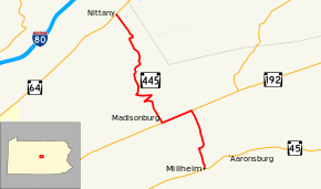
Pennsylvania Route 445 (PA 445) is a 12-mile-long (19 km) state highway located in Centre County, Pennsylvania. The southern terminus is at PA 45 in Millheim. The northern terminus is at PA 64 in Nittany.
Route description
PA 445 begins at an intersection with PA 45 in Millheim, heading north on two-lane undivided North Street. The road heads through residential areas with some farms, running to the west of Elk Creek. The route crosses into Penn Township and becomes an unnamed road, heading north across forested Brush Mountain. PA 445 enters Miles Township and continues into an agricultural valley, passing through Spring Bank and reaching an intersection with PA 192. At this point, the route turns west to form a concurrency with PA 192 on Brush Valley Road, passing more farms. PA 445 splits from PA 192 by heading north on Madisonburg Park through the residential community of Madisonburg. The route heads north across forested Nittany Mountain, becoming Madisonburg Pike Road. The road makes a few sharp turns to ascend the mountain before turning north and crossing into Walker Township. PA 445 becomes Gingerick Gap Road and winds north across more of the mountain. After crossing Nittany Mountain, the route turns northwest and passes through a mix of farms, woods, and homes before ending at PA 64 in Nittany.[2][3]
Major intersections
The entire route is in Centre County.
| Location | mi[1] | km | Destinations | Notes | |
|---|---|---|---|---|---|
| Millheim | 0.000 | 0.000 | |||
| Miles Township | 3.091 | 4.974 | Southern end of PA 192 concurrency | ||
| 4.596 | 7.397 | Northern end of PA 192 concurrency | |||
| Walker Township | 11.998 | 19.309 | |||
1.000 mi = 1.609 km; 1.000 km = 0.621 mi
| |||||
See also
 U.S. Roads portal
 Pennsylvania portal
References
- 1 2 "Pennsylvania state roads". Pennsylvania Spatial Data Access. Pennsylvania Department of Transportation. 2013. Retrieved March 14, 2013.
- ↑ Google (May 27, 2011). "overview of Pennsylvania Route 445" (Map). Google Maps. Google. Retrieved May 27, 2011.
- ↑ Centre County, Pennsylvania Highway Map (PDF) (Map). PennDOT. 2011. Retrieved May 27, 2011.