Centre Hall, Pennsylvania
| Centre Hall, Pennsylvania | |
|---|---|
| Borough | |
|
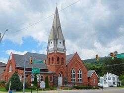
St. Luke Lutheran Church on Pennsylvania Avenue in Centre Hall | |
| Motto: In the Centre of it all! | |
 Map showing Centre Hall in Centre County | |
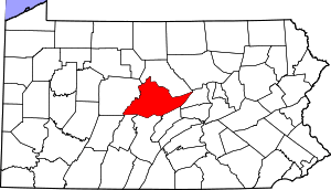 Map showing Centre County in Pennsylvania | |
 Centre Hall Location within the state of Pennsylvania | |
| Coordinates: 40°50′39″N 77°41′05″W / 40.84417°N 77.68472°WCoordinates: 40°50′39″N 77°41′05″W / 40.84417°N 77.68472°W | |
| Country | United States |
| State | Pennsylvania |
| County | Centre |
| Settled | 1847 |
| Incorporated (borough) | 1881 |
| Government | |
| • Mayor | Ray Hankinson |
| Area | |
| • Total | 0.6 sq mi (1.6 km2) |
| Elevation | 1,319 ft (402 m) |
| Population (2010) | |
| • Total | 1,265 |
| • Density | 2,054.2/sq mi (793.6/km2) |
| Time zone | Eastern (EST) |
| • Summer (DST) | EDT (UTC) |
| Zip | 16828 |
| Area code(s) | 814 |
| Website |
centrehall |
Centre Hall is a borough in Centre County, Pennsylvania, United States. It is located in Penns Valley and is part of the State College, Pennsylvania Metropolitan Statistical Area. The population was 1,265 at the 2010 census, which is a 17.2% increase from the 2000 census.
Geography
Centre Hall is located at 40°50′39″N 77°41′5″W / 40.84417°N 77.68472°W (40.844287, -77.684615).[1]
According to the United States Census Bureau, the borough has a total area of 0.6 square miles (1.6 km2), all of it land.
Events
Centre Hall hosts the Centre County Grange Encampment and Fair, known to most as the "Grange Fair". The Fair attracts tens of thousands of people during its run, and takes place the last full Thursday to Thursday week in August annually. It is one of the few remaining tenting fairs in the United States, with nearly a thousand "army-style" tents laid in rows throughout the grounds. Most tents are handed down through generations of fair-goers, and there is a lengthy waiting list for families who want to have their own tents.[2]
Demographics
| Historical population | |||
|---|---|---|---|
| Census | Pop. | %± | |
| 1880 | 350 | — | |
| 1890 | 441 | 26.0% | |
| 1900 | 537 | 21.8% | |
| 1910 | 500 | −6.9% | |
| 1920 | 525 | 5.0% | |
| 1930 | 658 | 25.3% | |
| 1940 | 738 | 12.2% | |
| 1950 | 834 | 13.0% | |
| 1960 | 1,109 | 33.0% | |
| 1970 | 1,282 | 15.6% | |
| 1980 | 1,233 | −3.8% | |
| 1990 | 1,203 | −2.4% | |
| 2000 | 1,079 | −10.3% | |
| 2010 | 1,265 | 17.2% | |
| Est. 2015 | 1,243 | [3] | −1.7% |
| Sources:[4][5][6] | |||
As of the census[5] of 2010, there were 1,265 people, 548 households, and 372 families residing in the borough. The population density was 2,054.2 people per square mile (793.6/km²). There were 574 housing units at an average density of 932.9 per square mile (360.1/km²). The racial makeup of the borough was 99.0% White, 0.1% Black or African American, 0.1% Native American, 0.2% Asian, 0.1% other, and 0.5% from two or more races.
There were 548 households, out of which 26.6% had children under the age of 18 living with them, 56.0% were married couples living together, 3.3% had a male householder with no wife present, 8.6% had a female householder with no husband present, and 32.1% were non-families. 27.7% of all households were made up of individuals, and 10.8% had someone living alone who was 65 years of age or older. The average household size was 2.31 and the average family size was 2.81.
In the borough the population was spread out, with 20.1% under the age of 18, 6.7% from 18 to 24, 26.2% from 25 to 44, 26.0% from 45 to 64, and 21.0% who were 65 years of age or older. The median age was 43 years. For every 100 females there were 88.2 males. For every 100 females age 18 and over, there were 87.6 males.
The median income for a household in the borough was $50,556, and the median income for a family was $64,141. The per capita income for the borough was $25,298. About 4.7% of families and 6.0% of the population were below the poverty line, including 11.9% of those under age 18 and 1.9% of those age 65 or over.
References
- ↑ "US Gazetteer files: 2010, 2000, and 1990". United States Census Bureau. 2011-02-12. Retrieved 2011-04-23.
- ↑ LeDon Young. "GrangeFair.net". Retrieved 2007-04-03.
- ↑ "Annual Estimates of the Resident Population for Incorporated Places: April 1, 2010 to July 1, 2015". Retrieved July 2, 2016.
- ↑ "Census of Population and Housing". U.S. Census Bureau. Archived from the original on 11 May 2015. Retrieved 11 December 2013.
- 1 2 "American FactFinder". United States Census Bureau. Archived from the original on 2013-09-11. Retrieved 2008-01-31.
- ↑ "Incorporated Places and Minor Civil Divisions Datasets: Subcounty Resident Population Estimates: April 1, 2010 to July 1, 2012". Population Estimates. U.S. Census Bureau. Archived from the original on 17 June 2013. Retrieved 11 December 2013.
External links
| Wikimedia Commons has media related to Centre Hall, Pennsylvania. |
- Centre Hall, Pa - Community Site
- Grange Fair - Centre County Grange Encampment and Fair, Centre Hall, PA