Pennsylvania Route 830
| ||||
|---|---|---|---|---|
|
PA 830 highlighted in red; the route prior to 2007 shown as a dotted red line | ||||
| Route information | ||||
| Maintained by PennDOT | ||||
| Length: | 10.99 mi[1] (17.69 km) | |||
| Existed: | 1928 – present | |||
| Major junctions | ||||
| West end: |
| |||
|
| ||||
| East end: |
| |||
| Location | ||||
| Counties: | Jefferson, Clearfield | |||
| Highway system | ||||
| ||||

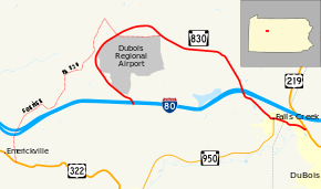
Pennsylvania Route 830 (PA 830) is a 10.99-mile-long (17.69 km) state highway located in Jefferson and Clearfield Counties in Pennsylvania. The western terminus is at Interstate 80 in Washington Township. The eastern terminus is at US 219 in Sandy Township.
Route description
PA 830 begins at an interchange with I-80 in Washington Township, Jefferson County, heading northwest on two-lane undivided Sensor Road. The road heads through forested areas, heading through an area of fields before curving northeast through more wooded areas on Airport Road. The route heads to the east and runs between woodland to the north and farms to the south as it passes to the north of DuBois Regional Airport. PA 830 heads east-southeast through a mix of farmland and woodland with some homes, continuing east into more wooded areas of residential development and passing through Rockdale. The road turns to the southeast and runs through more forests with some fields and homes, heading south to pass over I-80. The route passes through Red Mill and turns southeast into more forested areas with some residences, crossing into Falls Creek and becoming Washington Avenue. PA 830 passes several homes, turning to the east onto Main Street and coming to an intersection with the northern terminus of PA 950. Following this, the road passes more residences and businesses.[2][3] PA 830 enters Clearfield County and passes through more of Falls Creek before heading into Sandy Township, where it becomes Slab Run Road and crosses a Buffalo and Pittsburgh Railroad line immediately north of a junction with another Buffalo and Pittsburgh Railroad line. The route continues to the north of the railroad tracks, running through wooded areas with some commercial development as it comes to its eastern terminus at US 219.[2][4]
History
Prior to 2007, PA 830 ran further west into Washington and Pine Creek Townships.[5] The route began at US 322 near Emerickville. It had an interchange with I-80 at Exit 86 and traveled a winding route heading northeast. At Red Barn Road, it made a right turn and passed the old entrance to the DuBois Regional Airport. It made a sharp right curve at Allens Mills Road where the present routing continues today. The route between US 322 and Red Barn Road is still state-maintained as SR 1830 and the section of Red Barn Road between SR 1830 and the modern-day PA 830 is SR 1013.[3] Parts of the old PA 830 are still drivable between the PA 830 / SR 1830 intersection and Allens Mills Road, but it is not completely passable due to breaks in the pavement and the new parking lot for the airport.[2]
Construction began on the new five-mile (8-km) access road to the DuBois Airport and the new I-80 interchange in July 2004.[6] The project was completed in 2007 under budget and winning awards from the American Association of State Highway and Transportation Officials.[7]
Major intersections
| County | Location | mi[8] | km | Destinations | Notes |
|---|---|---|---|---|---|
| Jefferson | Washington Township | 0.00 | 0.00 | Exit 90 (I-80) | |
| Falls Creek | 9.80 | 15.77 | |||
| Clearfield | Sandy Township | 10.99 | 17.69 | ||
| 1.000 mi = 1.609 km; 1.000 km = 0.621 mi | |||||
See also
 U.S. Roads portal
 Pennsylvania portal
References
- ↑ "Pennsylvania state roads". Pennsylvania Spatial Data Access. Pennsylvania Department of Transportation. 2012. Retrieved December 25, 2012.
- 1 2 3 Google (August 10, 2011). "overview of Pennsylvania Route 830" (Map). Google Maps. Google. Retrieved August 10, 2011.
- 1 2 Jefferson County, Pennsylvania Highway Map (PDF) (Map). PennDOT. 2011. Retrieved June 2, 2011.
- ↑ Clearfield County, Pennsylvania Highway Map (PDF) (Map). PennDOT. 2011. Retrieved June 3, 2011.
- ↑ Jefferson County, Pennsylvania General Highway Map (PDF) (Map). PennDOT. 2005. Retrieved December 26, 2012.
- ↑ "News from around the area - Airport road opens". Endeavor News. July 21, 2007.
- ↑ "America's Transportation Award - 830 Airport Access Project". Retrieved December 26, 2012.
- ↑ "PennDOT VideoLog - Jefferson County - Route 0830". Pennsylvania Department of Transportation. September 23, 2010. Retrieved December 26, 2012.