Pennsylvania Route 829
| |||||||
|---|---|---|---|---|---|---|---|
 | |||||||
| Route information | |||||||
| Maintained by PennDOT | |||||||
| Length: | 17.04 mi[1] (27.42 km) | ||||||
| Major junctions | |||||||
| South end: |
| ||||||
| North end: |
| ||||||
| Location | |||||||
| Counties: | Huntingdon | ||||||
| Highway system | |||||||
| |||||||

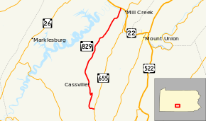
Pennsylvania Route 829 (PA 829) is a 17.04-mile-long (27.42 km) state highway located in Huntingdon County, Pennsylvania. The southern terminus is at Route 655 in Cass Township. The northern terminus is at U.S. Route 22 in Mill Creek.
Route description
PA 829 begins at an intersection with PA 655 in the community of Knightsville in Cass Township, heading west on a two-lane undivided road. The route runs through forested areas with some fields across a gap in Clear Ridge, curving to the north into a narrow agricultural valley. The road passes through an area of woods before coming into more farmland with some homes. At this point, PA 829 turns west and begins to ascend forested Sideling Hill, curving southwest and then northwest as it crosses the hill. After descending Sideling Hill, the route enters the Trough Creek Valley and heads north into Cassville and becomes Walnut Street, passing homes. Farther north, the road becomes Water Street and heads back into Cass Township, passing through agricultural areas with some residences and becoming an unnamed road. PA 829 curves to then north-northeast and runs through more areas of farms and woods with occasional homes. The route enters Union Township and passes through Calvin. The road continues northeast through more rural areas of the valley, passing through Colfax. Past here, PA 829 becomes Trough Creek Valley Road and heads into forests, crossing Sideling Hill again. After crossing the hill, the route continues through forests and crosses the Juniata River. At this point, PA 829 heads into Henderson Township and runs through rural areas of homes, crossing a Norfolk Southern railroad line before ending at US 22.[2][3]
Major intersections
The entire route is in Huntingdon County.
| Location | mi[1] | km | Destinations | Notes | |
|---|---|---|---|---|---|
| Cass Township | 0.00 | 0.00 | |||
| Mill Creek | 17.04 | 27.42 | |||
| 1.000 mi = 1.609 km; 1.000 km = 0.621 mi | |||||
See also
 U.S. Roads portal
 Pennsylvania portal
References
- 1 2 Pennsylvania State Roads - 2010. Harrisburg, Pennsylvania: Pennsylvania Department of Transportation. 2010.
- ↑ Google (June 1, 2011). "overview of Pennsylvania Route 829" (Map). Google Maps. Google. Retrieved June 1, 2011.
- ↑ Huntingdon County, Pennsylvania Highway Map (PDF) (Map). PennDOT. 2011. Retrieved June 1, 2011.