Pennsylvania Route 956
| ||||
|---|---|---|---|---|
 | ||||
| Route information | ||||
| Maintained by PennDOT | ||||
| Length: | 10.986 mi[1] (17.680 km) | |||
| Major junctions | ||||
| South end: |
| |||
| North end: |
| |||
| Location | ||||
| Counties: | Lawrence | |||
| Highway system | ||||
| ||||

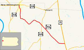
Pennsylvania Route 956 (PA 956) is a 10.98-mile-long (17.67 km) state highway located in Lawrence County in Pennsylvania. The southern terminus is at U.S. Route 19 in Scott Township. The northern terminus is at Pennsylvania Route 208 in New Wilmington. The route has followed its current alignment since 1932 and has been fully paved since 1940.
Route description
PA 956 begins at an intersection with US 19 in Scott Township, heading to the west on a two-lane undivided road. The route passes through a mix of farmland and woodland with some homes, turning to the northwest. The road continues through more rural areas, crossing into Washington Township. Farther northwest, PA 956 heads into Hickory Township and reaches an intersection with PA 168. After this junction, the route enters Wilmington Township and turns more to the west as it crosses the Neshannock Creek. The road continues along the northern bank of the creek, heading southwest through rural residential areas before bending northwest in the community of Neshannock Falls. PA 956 crosses the Little Neshannock Creek and continues through farms and woods with some homes, curving west before making a turn to the north. The road continues through rural areas before coming into New Wilmington, where it becomes South Market Street. Here, the route passes to the west of Westminster College before heading into the commercial downtown. PA 956 reaches its northern terminus at an intersection with PA 158 and PA 208, where the road continues north as part of PA 158.[2][3]
Major intersections
The entire route is in Lawrence County.
| Location | mi[1] | km | Destinations | Notes | |
|---|---|---|---|---|---|
| Scott Township | 0.000 | 0.000 | |||
| Hickory Township | 4.732 | 7.615 | |||
| New Wilmington | 10.986 | 17.680 | |||
| 1.000 mi = 1.609 km; 1.000 km = 0.621 mi | |||||
PA 956 Truck
| |
|---|---|
| Location: | Wilmington Township, Pennsylvania |
| Existed: | 2013–present |
Pennsylvania Route 956 Truck is a truck route around a weight-restricted bridge over the Neshannock Creek in Wilmington Township, Lawrence County, Pennsylvania. The route follows PA 208 and PA 168. It was signed in 2013.
See also
 U.S. Roads portal
 Pennsylvania portal
References
- 1 2 Pennsylvania State Roads - 2010. Harrisburg, Pennsylvania: Pennsylvania Department of Transportation. 2010.
- ↑ Google (May 21, 2011). "overview of Pennsylvania Route 956" (Map). Google Maps. Google. Retrieved May 21, 2011.
- ↑ Lawrence County, Pennsylvania Highway Map (PDF) (Map). PennDOT. 2011. Retrieved May 21, 2011.