U.S. Route 19 in Pennsylvania
| ||||
|---|---|---|---|---|
|
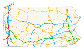
Route highlighted in red | ||||
| Route information | ||||
| Maintained by PennDOT | ||||
| Length: | 195 mi[1] (314 km) | |||
| Major junctions | ||||
| South end: |
| |||
|
| ||||
| North end: |
| |||
| Location | ||||
| Counties: | Greene, Washington, Allegheny, Butler, Lawrence, Mercer, Crawford, Erie | |||
| Highway system | ||||
| ||||
U.S. Route 19 in Pennsylvania closely parallels Interstate 79 for its entire length. US 19 enters Pennsylvania in Greene County near Mount Morris. Its northern terminus is in the city of Erie. Part is named for Commodore Oliver Hazard Perry, hero of the Battle of Lake Erie.
Route description
In northern Washington County, U.S. Route 19 was modernized after the former Pittsburgh Railways Interurban (PRCo) trolley service was discontinued in August 1953. Initially Route 19 ran parallel to the trolley line, and later expanded over the tracks through part of Mt. Lebanon in southern Allegheny County.
US 19 then proceeds north through Pittsburgh's Northside, West View, Perrysville and Ross Township, McCandless Township and Wexford, where it is referred to as Perry Highway. In Cranberry Township, it connects with I-79, the Pennsylvania Turnpike, and PA 228. Continuing through Mercer and Crawford counties, the route terminates in the city of Erie.
A Truck 19 designation exists in Pittsburgh, running from Wexford, Pennsylvania to Mt. Lebanon, Pennsylvania. Although both of that route's termini are with the regular U.S. 19, the two routes also intersect near the Fort Pitt Tunnel on Pittsburgh's West End.[1]
History
Major intersections
| County | Location | mi[1] | km | Destinations | Notes |
|---|---|---|---|---|---|
| Greene | Perry Township | 0.0 | 0.0 | US 19 enters Pennsylvania from West Virginia | |
| Morrisville | 15.4 | 24.8 | Southern terminus of PA 21 concurrency | ||
| Waynesburg | Northern terminus of PA 218 | ||||
| 16.8 | 27.0 | Northern terminus of PA 21 concurrency | |||
| Washington Township | 21.9 | 35.2 | PA 221 provides access to I-79 north; I-79 exit 19 | ||
| 22.1 | 35.6 | I-79 exit 19 | |||
| Washington | South Strabane Township | 33.6 | 54.1 | I-79 exit 30 | |
| 37.0 | 59.5 | Southern terminus of US 40 concurrency | |||
| Washington | 39.0 | 62.8 | Northern terminus of US 40 concurrency | ||
| 39.2 | 63.1 | ||||
| South Strabane Township | 40.6 | 65.3 | I-70 exit 19 | ||
| North Strabane Township | 45.5 | 73.2 | Interchange | ||
| Peters Township | Valley Brook Road – Lawrence | Interchange | |||
| Allegheny | Upper St. Clair | 55.6 | 89.5 | Interchange | |
| Mt. Lebanon | 57.6 | 92.7 | Southern terminus of Yellow Belt concurrency | ||
| 58.1 | 93.5 | Southern terminus of Truck US 19 | |||
| 59.1 | 95.1 | Southern terminus of PA 121, northern terminus of Yellow Belt concurrency | |||
| Pittsburgh | 60.6 | 97.5 | |||
| 62.8 | 101.1 | I-376/US 22/US 30 exit 69, southern terminus of PA 51 concurrency | |||
| 64.1 | 103.2 | Interchange, northern terminus of PA 51 concurrency, northern terminus of PA 837, southern terminus of PA 60, West End Circle | |||
| Ohio River | West End Bridge | ||||
| Pittsburgh | 64.6 | 104.0 | Interchange, southern terminus of PA 65 concurrency | ||
| 65.3 | 105.1 | Interchange, northern terminus of PA 65 concurrency | |||
| 68.6 | 110.4 | Southern terminus of Blue Belt concurrency | |||
| 69.0 | 111.0 | Northern terminus of Blue Belt concurrency | |||
| 69.4 | 111.7 | Interchange, I-279 exit 5 via Cemetery Lane | |||
| 69.9 | 112.5 | HOV Only | |||
| Ross Township | 73.0 | 117.5 | Southern terminus of Green Belt concurrency | ||
| 73.0 | 117.5 | Northern terminus of Green Belt concurrency | |||
| McCandless Township | 75.6 | 121.7 | |||
| 76.2 | 122.6 | Northern terminus of Truck US 19, southbound access only | |||
| Franklin Park | 78.9 | 127.0 | Interchange | ||
| Marshall Township | 81.5 | 131.2 | |||
| 82.2 | 132.3 | Southbound access only; I-79 exit 75 | |||
| Butler | Cranberry Township | 83.3 | 134.1 | I-76 / Penna Turnpike exit 28 (Cranberry) | |
| 83.8 | 134.9 | Western terminus of PA 228 | |||
| Jackson Township | 88.8 | 142.9 | Southern terminus of PA 528 | ||
| Zelienople | 90.2 | 145.2 | No southbound exit, I-79 exit 85 | ||
| 91.6 | 147.4 | Southern terminus of PA 68 concurrency | |||
| 91.9 | 147.9 | Eastern terminus of PA 288 | |||
| 92.0 | 148.1 | Northern terminus of PA 68 concurrency | |||
| Portersville | 101.4 | 163.2 | Eastern terminus of PA 488 concurrency | ||
| 101.6 | 163.5 | Western terminus of PA 488 concurrency | |||
| Muddy Creek Township | 104.7 | 168.5 | Interchange | ||
| Lawrence | Scott Township | 105.8 | 170.3 | ||
| 106.1 | 170.8 | Southern terminus of PA 956 | |||
| Mercer | Springfield Township | 112.5 | 181.1 | Southern terminus of PA 208 concurrency | |
| 112.6 | 181.2 | Northern terminus of PA 208 concurrency | |||
| Findley Township | 116.9 | 188.1 | I-80 exit 15 | ||
| Mercer | 119.1 | 191.7 | |||
| 119.2 | 191.8 | One-way eastbound, southern terminus of PA 58 eastbound/PA 258 southbound concurrency | |||
| 119.21 | 191.85 | Northern terminus of PA 258 southbound concurrency, southern terminus of US 62/PA 258 northbound concurrency | |||
| 119.22 | 191.87 | One-way westbound, northern terminus of PA 258 northbound concurrency, southern terminus of PA 58 westbound concurrency | |||
| 119.4 | 192.2 | Northern terminus of PA 58 concurrency | |||
| 119.8 | 192.8 | Northern terminus of US 62 concurrency | |||
| Perry Township | 131.2 | 211.1 | |||
| Crawford | Greenwood Township | 141.4 | 227.6 | ||
| Meadville | 147.2 | 236.9 | Southern terminus of US 6/US 322 concurrency, southern terminus of PA 98 | ||
| 148.4 | 238.8 | I-79 exit 147 | |||
| 149.0 | 239.8 | Southern terminus of PA 102 | |||
| 150.1 | 241.6 | Northern terminus of US 322 concurrency | |||
| Saegertown | 156.5 | 251.9 | Southern terminus of PA 198 concurrency | ||
| 157.2 | 253.0 | Northern terminus of PA 198 concurrency | |||
| Cambridge Springs | 165.2 | 265.9 | Northern terminus of PA 86, western terminus of PA 408 | ||
| 165.4 | 266.2 | Southern terminus of PA 99 | |||
| Erie | Mill Village | 171.4 | 275.8 | Eastern terminus of US 6N Northern terminus of US 6 concurrency | |
| Waterford | 175.2 | 282.0 | Roundabout, southern terminus of PA 97 concurrency | ||
| 176.7 | 284.4 | Northern terminus of PA 97 concurrency | |||
| Summit Township | 184.8 | 297.4 | I-90 exit 24 | ||
| Millcreek Township | 186.1 | 299.5 | Northern terminus of PA 99 | ||
| Erie | 189.5 | 305.0 | Northern terminus of US 19 | ||
1.000 mi = 1.609 km; 1.000 km = 0.621 mi
| |||||
See also
 U.S. Roads portal
 Pennsylvania portal
 Erie portal
 Pittsburgh portal
References
| Wikimedia Commons has media related to U.S. Route 19 in Pennsylvania. |
- 1 2 3 Google (2008-10-13). "US 19 in PA Overview" (Map). Google Maps. Google. Retrieved 2008-10-13.
| Previous state: West Virginia |
Pennsylvania | Next state: Terminus |

