Pennsylvania Route 958
| ||||
|---|---|---|---|---|
 | ||||
| Route information | ||||
| Maintained by PennDOT | ||||
| Length: | 8.633 mi[1] (13.893 km) | |||
| Existed: | 1928 – present | |||
| Major junctions | ||||
| South end: |
| |||
| North end: |
| |||
| Location | ||||
| Counties: | Warren | |||
| Highway system | ||||
| ||||

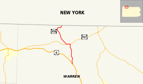
Pennsylvania Route 958 (also designated by the Pennsylvania Department of Transportation as SR 0958) is an 8.63-mile-long (13.89 km) state highway located in Warren County, Pennsylvania. The designation's southern terminus is at an intersection with U.S. Route 6 in Pittsfield Township. The route heads through several small communities, including Lottsville, where it goes on a short concurrency with Pennsylvania Route 957. The northern terminus is at the New York state line at Freehold Township, just east of Bear Lake. There, the route continues through New York as Chautauqua County Route 33. Route 958 was designated in 1928 as a connector from U.S. Route 6 to the community of Wrightsville, where the designation terminated. The route was extended northward along its current alignment in 1936 and has remained unchanged since.
Route description
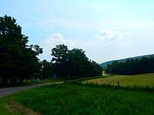
State Route 958 begins at an intersection with a two-lane U.S. Route 6 east of the city of Corry. The route progresses northward as a two-lane roadway through the rural regions of western Pennsylvania. Route 958 soon enters the community of Wrightsville, a small community of a few residences and mostly fields. At Deadmans Run Road, the highway begins to cross through a populated area, however, it soon leaves Wrightsville and turns to the northwest in the deep fields north of the community. The northwestern bend curves back to the northward progression and Route 958 passes through a large farm near an intersection with Kidder Road. Some residences parallel the highway as it makes another northwestern bend and soon comes on a northward stretch into the community of Lottsville, where the highway intersects with Route 957.[2]
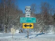
At the intersection, Routes 957 and 958 become concurrent along a westbound residential street, until leaving Lottsville, where the two routes turn to the southwest in fields. As Routes 957 and 958 approach a railroad line used by Norfolk Southern (and previously the Erie Railroad), Route 958 forks to the north, paralleling and soon crossing the rails northwest of Lottsville. The distinctively rural surroundings for Route 958 return, and the Norfolk Southern line parallels to the east as the highway curves northwestward. Soon, Route 958 returns to a farming region and curves away from the railroad on a mountainside. After passing a large pond, the route intersects Greeley Street a t-intersection in Bear Lake, where Route 958 turns eastward through the rural areas before intersecting with North Road, where the route turns northward and reaches the New York state line near Niobe, New York. Route 958 terminates here, and the right-of-way continues northward as Chautauqua County Route 33 (Panama–Bear Lake Road).[2]
History
Route 958 was first designated among many regional highways in the 1928 mass renumbering of state highways throughout Pennsylvania. The alignment, however was only a stub designation, connecting the southern terminus of U.S. Route 6 (formerly State Route 7[3]) to the borough of Wrightsville, only a short distance away.[4] The alignment designed in 1928 only remained intact eight years into 1936, when it was extended northward to its current terminus at the New York state line near Bear Lake, Pennsylvania and Niobe, New York in 1936.[5] The alignment has remained unchanged since the 1936 extension.[6]
Major intersections
The entire route is in Warren County.
| Location | mi[1] | km | Destinations | Notes | |
|---|---|---|---|---|---|
| Pittsfield Township | 0.000 | 0.000 | Southern terminus | ||
| Freehold Township | 3.580 | 5.761 | Eastern terminus of concurrency with PA 957 | ||
| 4.225 | 6.799 | Western terminus of concurrency with PA 957 | |||
| 8.633 | 13.893 | Northern terminus | |||
1.000 mi = 1.609 km; 1.000 km = 0.621 mi
| |||||
See also
 U.S. Roads portal
 Pennsylvania portal
References
- 1 2 Bureau of Maintenance and Operations (January 2015). Roadway Management System Straight Line Diagrams (Report) (2015 ed.). Pennsylvania Department of Transportation. Retrieved June 30, 2015.
- Warren County (PDF)
- 1 2 Microsoft; Nokia (May 25, 2010). "Overview map of Pennsylvania Route 958" (Map). Bing Maps. Microsoft. Retrieved May 25, 2010.
- ↑ Map Showing Pennsylvania State Highways (Map). Cartography by Pennsylvania Department of Highways. Harrisburg, Pennsylvania: Pennsylvania Department of Highways. 1927.
- ↑ Map Showing Pennsylvania State Highways (Map). Cartography by Pennsylvania Department of Highways. Harrisburg, Pennsylvania: Pennsylvania Department of Highways. 1928.
- ↑ Pennsylvania State Highways (Map). Cartography by Pennsylvania Department of Highways. Harrisburg, Pennsylvania: Pennsylvania Department of Highways. 1936.
- ↑ Official Transportation Map - Pennsylvania (Map). Cartography by Pennsylvania Department of Transportation. Harrisburg, Pennsylvania: Pennsylvania Department of Transportation. 1928.
External links
- Kitsko, Jeffrey J. (2009). "PA 958". Pennsylvania Highways. pp. 951–999. Retrieved May 25, 2010.
- Prince, Adam (2002). "PA 958". State-Ends.com. Retrieved May 25, 2010.