U.S. Route 6 in Pennsylvania
| |||||||
|---|---|---|---|---|---|---|---|
| GAR Highway; Roosevelt Highway | |||||||
 | |||||||
| Route information | |||||||
| Maintained by PennDOT | |||||||
| Length: | 403 mi[1] (649 km) | ||||||
| Existed: | 1926 (1924 as PA 7) – present | ||||||
| Tourist routes: |
Gateway to the Endless Mountains Scenic Byway Governor Casey Scenic Byway | ||||||
| Major junctions | |||||||
| West end: |
| ||||||
|
| |||||||
| East end: |
| ||||||
| Location | |||||||
| Counties: | Crawford, Erie, Warren, McKean, Potter, Tioga, Bradford, Wyoming, Lackawanna, Wayne, Pike | ||||||
| Highway system | |||||||
| |||||||

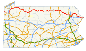
U.S. Route 6 travels east–west near the north edge of the U.S. state of Pennsylvania from the Ohio state line near Pymatuning Reservoir east to the Mid-Delaware Bridge over the Delaware River into Port Jervis, New York. It is the longest highway segment in the Commonwealth. Most of it is a two-lane rural highway, with some freeway bypasses around larger towns. Except east of Scranton, where it is paralleled by Interstate 84, it is the main route in its corridor. What is now Interstate 80—the Keystone Shortway—was once planned along the US 6 corridor as a western extension of I-84.[2] The corridor was originally the Roosevelt Highway from Erie, Pennsylvania to Port Jervis, New York, designated Pennsylvania Route 7 in 1924.[3] The PA 7 designation soon disappeared, but as US 6 was extended and relocated, the Roosevelt Highway followed it. The Pennsylvania section of US 6 was renamed the Grand Army of the Republic Highway in 1946; this name was applied to its full transcontinental length by 1953.[4]
US 6 meets with U.S. Route 19 near Meadville, where it turns north with US 19 to a point east of Edinboro. There it turns east (while U.S. Route 6N heads west to U.S. Route 20 at West Springfield) and passes through the Northern Tier of Pennsylvania. At Towanda it turns more southeasterly to reach Scranton, then turning back northeast out of Scranton to Carbondale and generally east and southeast to New York. US 6 fully encompasses two Pennsylvania Scenic Byways: the Gateway to the Endless Mountains Scenic Byway along the bypass of Tunkhannock and the Governor Casey Scenic Byway along the freeway portion in Lackawanna County between I-81 in Dunmore and PA 247 in Jessup.[5][6]
History
As approved by the American Association of State Highway Officials (AASHO) on November 11, 1926, the west end of US 6 was at Kane, where U.S. Route 120 continued west to Erie. (US 6 ended concurrent with U.S. Route 219, which ran east to Mt. Jewett along US 6 before turning north to New York.) US 6 also used present Pennsylvania Route 706, U.S. Route 11 and Pennsylvania Route 106 between Wyalusing and Carbondale, while U.S. Route 106 took the southerly route via Scranton.[7][8]
By the end of 1927, US 6 had replaced US 120 in running west from Kane to Erie (making US 120 no longer connect to its "parent" U.S. Route 20), and had swapped places with US 106 via Scranton; this took it along the Jefferson Highway. It was defined by AASHO to serve the following places in Pennsylvania: Erie, Waterford, Corry, Warren, Kane, Farmers Valley, Coudersport, Wellsboro, Canoe Camp, Mansfield, Towanda, Wyalusing, Tunkhannock, Clarks Summit, Scranton, Carbondale, Honesdale, Milford, and Matamoras.[9] By 1930 its west end was at 26th Street (U.S. Route 20) and State Street (US 6 - now Pennsylvania Route 505) in Erie. (By then U.S. Route 19 ended a block to the west on Peach Street, where it still ends today.)[10]
This original routing deviates majorly from present US 6 in the following places, roughly using the following current routes:[8]
- Pennsylvania Route 505 and Pennsylvania Route 97, Erie to Union City
- Pennsylvania Route 46, Pennsylvania Route 446 and Pennsylvania Route 155, Smethport to Port Allegany
- Pennsylvania Route 660 and U.S. Route 15 Business west of Mansfield
- Pennsylvania Route 92 and Pennsylvania Route 307, Tunkhannock to Clarks Summit
In 1931,[4] US 6 was extended west to Greeley, Colorado. It left its old route - which then became U.S. Route 6N - at Waterford, and headed south on former Pennsylvania Route 5 and U.S. Route 19 and west on U.S. Route 322 and former Pennsylvania Route 77 into Ohio. This whole section from Waterford to Cleveland, Ohio was regarded as temporary, but the only change was a relocation by 1936 along Pennsylvania Route 79 from Union City west to US 19 south of Waterford. (Former US 6 from Mount Union to Waterford became Pennsylvania Route 97. At the same time, US 6N was moved to the rest of former PA 79 from US 19 west to U.S. Route 20 - its current route.)[11]
Since then, only minor realignments and bypasses have been made to the route of US 6.
Major intersections
| County | Location[12] | mi | km | Exit | Destinations | Notes |
|---|---|---|---|---|---|---|
| Crawford | Conneaut Township | 0.0 | 0.0 | Continues into Ohio | ||
| Sadsbury Township | 13.4 | 21.6 | Southern terminus of PA 618 | |||
| Conneaut Lake | 13.9 | 22.4 | Western end of concurrency with PA 285 | |||
| 14.3 | 23.0 | Western end of concurrencies with US 322 and PA 18 | ||||
| 14.4 | 23.2 | Eastern end of concurrency with PA 285 | ||||
| Sadsbury Township | 15.3 | 24.6 | Eastern end of concurrency with PA 18 | |||
| Vernon Township | 19.9 | 32.0 | Southern end of concurrency with US 19, southern terminus of PA 98 | |||
| 21.0 | 33.8 | I-79 exit 147 | ||||
| 21.8 | 35.1 | Southern terminus of PA 102 | ||||
| Meadville | 22.8 | 36.7 | Eastern end of concurrency with US 322 | |||
| Saegertown | 29.3 | 47.2 | Southern end of concurrency with PA 198 | |||
| 30.0 | 48.3 | Northern end of concurrency with PA 198 | ||||
| Cambridge Springs | 38.1 | 61.3 | Northern and Western termini of PA 86/408 respectively | |||
| 38.2 | 61.5 | Southern terminus of PA 99 | ||||
| Erie | LeBoeuf Township | 44.2 | 71.1 | Northern end of concurrency with US 19, eastern terminus of US 6N | ||
| Union City | 52.9 | 85.1 | Southern end of concurrency with PA 8 | |||
| 53.5 | 86.1 | Northern end of concurrency with PA 8 | ||||
| Elgin–Wayne Township line | 59.2 | 95.3 | Western end of concurrency with PA 89 | |||
| Wayne Township | 60.8 | 97.8 | Eastern end of concurrency with PA 89 | |||
| Corry | 64.8 | 104.3 | ||||
| Warren | Columbus Township | 67.6 | 108.8 | Western terminus of PA 957 | ||
| Pittsfield Township | 77.0 | 123.9 | Southern terminus of PA 958 | |||
| 82.6 | 132.9 | Western end of concurrency with PA 27 | ||||
| Youngsville | 85.3 | 137.3 | Eastern end of concurrency with PA 27 | |||
| Brokenstraw Township | Youngsville, Irvine | Interchange | ||||
| 89.1 | 143.4 | Western end of concurrency with US 62, interchange | ||||
| Warren | 94.0 | 151.3 | Western terminus of US 6 BUS, eastern end of concurrency with US 62, interchange | |||
| Main Avenue | Eastbound exit and westbound entrance | |||||
| Mead Township | 96.9 | 155.9 | Eastern terminus of US 6 BUS | |||
| 97.1 | 156.3 | Western terminus of PA 59 | ||||
| Sheffield Township | 107.1 | 172.4 | Eastern terminus of PA 666 | |||
| McKean | Kane | 122.6 | 197.3 | Northern terminus of PA 66 | ||
| 123.1 | 198.1 | Western end of concurrency with PA 321 | ||||
| 123.2 | 198.3 | Eastern end of concurrency with PA 321 | ||||
| Hamlin Township | 130.6 | 210.2 | ||||
| 140.3 | 225.8 | Western terminus of PA 146 | ||||
| Smethport | 147.9 | 238.0 | Eastern terminus of PA 59 | |||
| 148.9 | 239.6 | Western end of concurrency with PA 46 | ||||
| Keating Township | 149.6 | 240.8 | Eastern end of concurrency with PA 46 | |||
| Port Allegany | 157.3 | 253.1 | Northern end of concurrency with PA 155 | |||
| 158.5 | 255.1 | Southern end of concurrency with PA 155 | ||||
| Potter | Coudersport | 174.7 | 281.2 | Western end of concurrency with PA 44 | ||
| 176.7 | 284.4 | Northern terminus of PA 872 | ||||
| Sweden Township | 178.8 | 287.8 | Eastern end of concurrency with PA 44 | |||
| Ulysses Township | 189.3 | 304.6 | Southern terminus of PA 449 | |||
| Galeton | 196.9 | 316.9 | Northern terminus of PA 144 | |||
| Tioga | Gaines Township | 201.5 | 324.3 | Southern terminus of PA 349 | ||
| Shippen Township | 208.9 | 336.2 | Western terminus of PA 362 | |||
| Delmar Township | 216.9 | 349.1 | Western end of concurrency with PA 287 | |||
| Wellsboro | 219.5 | 353.3 | Eastern end of concurrency with PA 287, western end of concurrency with PA 660 | |||
| Charleston Township | 225.8 | 363.4 | Eastern end of concurrency with PA 660 | |||
| Mansfield | 231.5 | 372.6 | Interchange | |||
| 232.2 | 373.7 | |||||
| Richmond Township | 234.0 | 376.6 | Southern terminus of PA 549 | |||
| Bradford | Troy | 249.2 | 401.0 | Western end of concurrency with PA 14 | ||
| Troy Township | 249.9 | 402.2 | Eastern end of concurrency with PA 14 | |||
| North Towanda Township | 266.7 | 429.2 | Interchange | |||
| Wysox Township | 272.8 | 439.0 | ||||
| Wyalusing Township | 280.3 | 451.1 | Southern terminus of PA 409 | |||
| Wyalusing | 285.1 | 458.8 | Western terminus of PA 706 | |||
| Wyoming | Braintrim Township | 293.2 | 471.9 | Southern terminus of PA 367 | ||
| Meshoppen | 300.2 | 483.1 | Southern terminus of PA 267 | |||
| Washington Township | 303.6 | 488.6 | Northern terminus of PA 87 | |||
| Tunkhannock Township | 307.8 | 495.4 | Western terminus of US 6 Bus. | |||
| Tunkhannock | 309.6 | 498.3 | ||||
| Tunkhannock Township | 310.2 | 499.2 | Western end of concurrency with PA 92 | |||
| 310.4 | 499.5 | Eastern terminus of US 6 BUS | ||||
| 312.7 | 503.2 | Eastern end of concurrency with PA 92 | ||||
| Clinton Township | 318.7 | 512.9 | Northern end of concurrency with US 11 | |||
| Clinton Township–Factoryville line | 319.3 | 513.9 | Western terminus of PA 107 | |||
| Lackawanna | La Plume Township | 321.3 | 517.1 | Western terminus of PA 438 | ||
| Dalton | 323.1 | 520.0 | Western terminus of PA 632, interchange | |||
| South Abington Township | 328.0 | 527.9 | ||||
| Western terminus of freeway | ||||||
| 328.2 | 528.2 | Eastern end of concurrency with US 11 | ||||
| Northern terminus of I-476, I-476 / Penna Turnpike NE Extension exit 131 (Clarks Summit) | ||||||
| Western end of concurrency with I-81, I-81 exit 194 | ||||||
| Scranton | 191 | Western terminus of US 6 BUS | ||||
| 190 | Main Avenue – Dickson City | |||||
| Dunmore | 334.0 | 537.5 | 188 | |||
| 335.6 | 540.1 | Eastern end of concurrency with I-81, I-81 exit 187; Western terminus of I-84 and northern terminus of I-380, I-84/I-380 exit 1 | ||||
| Throop | 1 | Marshwood Road – Mount Cobb, Throop | ||||
| Olyphant | 2 | East Lackawanna Avenue – Olyphant | ||||
| Jessup | 340.2 | 547.5 | 3 | |||
| Archbald | 4 | Salem Road – Archbald, Cortez | ||||
| Archbald–Mayfield line | 345.6 | 556.2 | 5 | Eastern terminus of PA 107 | ||
| Carbondale Township | 6 | Meredith Street – Carbondale, Childs | ||||
| Eastern terminus of freeway | ||||||
| 350.6 | 564.2 | 7 | Eastern terminus of US 6 Bus. | |||
| Wayne | Waymart | 354.3 | 570.2 | |||
| Prompton | 358.5 | 576.9 | Southern terminus of PA 170 | |||
| Honesdale | 362.8 | 583.9 | Northern end of concurrency with PA 191 | |||
| 363.4 | 584.8 | Southern end of concurrency with PA 191 | ||||
| Texas Township | 366.2 | 589.3 | Western terminus of PA 652 | |||
| Hawley | 371.6 | 598.0 | Northern end of concurrency with PA 590 | |||
| Palmyra Township | 373.5 | 601.1 | Southern end of concurrency with PA 590 | |||
| Pike | Palmyra Township | 374.9 | 603.3 | Northern terminus of PA 507 | ||
| Blooming Grove Township | 377.4 | 607.4 | Northern terminus of PA 402 | |||
| Blooming Grove–Lackawaxen township line | 380.9 | 613.0 | Northern terminus of PA 739 | |||
| 384.7 | 619.1 | Western end of concurrency with PA 434 | ||||
| Dingman–Milford township line | 395.5 | 636.5 | Interchange, I-84 exit 46 | |||
| Milford | 397.7 | 640.0 | Western end of concurrency with US 209 | |||
| Westfall Township | 402.9 | 648.4 | Interchange, I-84 exit 53 | |||
| Delaware River | Mid-Delaware Bridge | |||||
| Continues into New York | ||||||
1.000 mi = 1.609 km; 1.000 km = 0.621 mi
| ||||||
See also
 U.S. Roads portal
 Pennsylvania portal
References
- ↑ Google (24 December 2012). "Driving directions From Linesville to Matamoras" (Map). Google Maps. Google. Retrieved 24 December 2012.
- ↑ Official Route Numbering for the National System of Interstate and Defense Highways, August 14, 1957
- Note: the corridor had already been shifted south by September 1955, but the numbering was done on a map from August 2, 1947.
- ↑ "U.S. 22 - The William Penn Highway". Federal Highway Administration. Retrieved 6 October 2014.
- 1 2 Richard F. Weingroff. "U.S. 6 - The Grand Army of the Republic Highway". Retrieved October 6, 2014.
- ↑ "Gateway to the Endless Mountains". VisitPA.com. Retrieved March 27, 2012.
- ↑ "Governor Casey". VisitPA.com. Retrieved March 27, 2012.
- ↑ Bureau of Public Roads & American Association of State Highway Officials (November 11, 1926). United States System of Highways Adopted for Uniform Marking by the American Association of State Highway Officials (Map). 1:7,000,000. Washington, DC: U.S. Geological Survey. OCLC 32889555. Retrieved November 7, 2013 – via University of North Texas Libraries.
- 1 2 1927 map of Pennsylvania
- ↑ United States Numbered Highways, 1927
- ↑ 1930 map of Pennsylvania, back side 5.75 MiB
- ↑ Ohio Transportation Maps
- ↑ "Video Log". Pennsylvania Department of Transportation. Retrieved June 10, 2016.
External links
| Wikimedia Commons has media related to U.S. Route 6 in Pennsylvania. |
| Previous state: Ohio |
Pennsylvania | Next state: New York |