Penrose, New Zealand
| Penrose | |
|---|---|
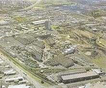
 Penrose business plaza, an office skyscraper in the area, a local landmark - it towers over most of the lower buildings of the area | |
| Basic information | |
| Local authority | Auckland Council |
| Electoral ward | Maungakiekie-Tamaki |
| Local board | Maungakiekie-Tamaki |
| Board subdivision | Maungakiekie |
| Date established | 1860s (approx.) |
| Population | 675 (2006) |
| Facilities | |
| Train station(s) | Penrose Train Station |
| Surrounds | |
| North | Ellerslie |
| Northeast | Ellerslie |
| East | Mount Wellington |
| Southeast | Southdown |
| South | Te Papapa |
| Southwest | Oranga |
| West | One Tree Hill |
| Northwest | Greenlane |
Penrose is an industrial suburb in Auckland, New Zealand. It is located to the southeast of the city centre, at a distance of about nine kilometres, between the suburbs of Oranga and Mount Wellington, and close to the Mangere Inlet, an arm of the Manukau Harbour. According to the 2006 census, Penrose has a population of only 675, due to the high intensity of industrial and commercial sites in the area.[1]
In 2008, there were 44,975 employees and 4,998 businesses in the Penrose area, 14 per cent of Auckland City's employment, making up seven per cent of its businesses. Of these, 16% were in manufacturing, 14% in wholesale trade, 10% in administrative and support services, 10% in professional, scientific and technical services, 8% in construction and 6% in transport, postal and warehousing business types.[2]
History
The area was purchased from three local Maori Chiefs by The Wiiliams family in the late 1830's, the farm being called Penrose after their home area in Cornwall, England.
The railway line between Auckland and Onehunga running through Penrose (now known as the Onehunga Line) was one of the first Government funded railways in New Zealand, being opened in 1873. It was built by the Auckland provincial government.
Industry started to flourish in the area from the 1920s, due to its close connection to the main railway line and the main road (Great South Road) with these important transport links later strengthened by the motorway (State Highway 1) built following the same alignment in the 1950s. By this time, around 5,000 workers were employed in the suburb.[3]
The new motorway and the move of industrial and manufacturing occupations out of older centres like the Auckland CBD soon started a boom in the Penrose-Mount Wellington area. Industry also successfully lobbied for state housing to be built close by, to provide the new area with a supply of labour.[3] To this day, the area remains almost exclusively industrial, with a mix of run-down areas and newly established sites.
Education
Despite the low local population, Penrose is the site of the former Penrose High School, which in 2008 renamed itself One Tree Hill College, to shed the 'industrial' associations of the name.[4] The school attracts many students from out of the suburb, many of its students coming from as far as 20 km away. Other State secondary schools serving the area include St Peter's College. The turnoff of the Onehunga Branch railway line from the North Auckland Line is also located in Penrose.
The Auckland Japanese Supplementary School (AJSS; オークランド日本語補習学校 Ōkurando Nihongo Hoshūgakkō), a Japanese supplementary school, holds its classes at One Tree Hill College.[5]
Sport and recreation
Penrose is home to the New Zealand Warriors, who are based at Mount Smart Stadium.
References
| Wikimedia Commons has media related to Penrose, New Zealand. |
- ↑ Quickstats about Penrose
- ↑ Penrose business precinct - Key statistics (from the Auckland City Council website. Accessed 2009-11-15.)
- 1 2 New Zealand Historical Atlas - McKinnon, Malcolm (Editor); David Bateman, 1997, Plate 75
- ↑ McKenzie-Minifie, Martha (22 July 2008). "School sheds 'industrial' name". The New Zealand Herald. Retrieved 2 November 2011.
- ↑ "お問い合わせ" (Archive). Auckland Japanese Supplementary School. Retrieved on 1 February 2015. "所在地 One Tree Hill College 421-451 Great South Rd, Penrose, Auckland"
External links
- Photographs of Penrose held in Auckland Libraries' heritage collections.
Coordinates: 36°55′S 174°49′E / 36.91°S 174.81°E