Pettoranello del Molise
| Pettoranello del Molise | |
|---|---|
| Comune | |
| Comune di Pettoranello del Molise | |
 Pettoranello del Molise Location of Pettoranello del Molise in Italy | |
| Coordinates: 41°34′N 14°17′E / 41.567°N 14.283°ECoordinates: 41°34′N 14°17′E / 41.567°N 14.283°E | |
| Country | Italy |
| Region | Molise |
| Province / Metropolitan city | Province of Isernia (IS) |
| Area | |
| • Total | 15.5 km2 (6.0 sq mi) |
| Population (Dec. 2004) | |
| • Total | 470 |
| • Density | 30/km2 (79/sq mi) |
| Time zone | CET (UTC+1) |
| • Summer (DST) | CEST (UTC+2) |
| Postal code | 86090 |
| Dialing code | 0865 |
Pettoranello del Molise is a comune (municipality) in the Province of Isernia in the Italian region Molise, located about 30 kilometres (19 mi) west of Campobasso and about 6 kilometres (4 mi) southeast of Isernia. As of 31 December 2004, it had a population of 470 and an area of 15.5 square kilometres (6.0 sq mi).[1]
Pettoranello del Molise borders the following municipalities: Carpinone, Castelpetroso, Castelpizzuto, Isernia, Longano.
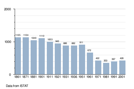
Demographic evolution
Sister cities
References
- ↑ All demographics and other statistics: Italian statistical institute Istat.
- ↑ Princeton-Pettoranello Sister City Foundation. Accessed November 24, 2011.
This article is issued from Wikipedia - version of the 1/31/2015. The text is available under the Creative Commons Attribution/Share Alike but additional terms may apply for the media files.