Phnom Kulen National Park
| Phnom Kulen National Park | |
|---|---|
|
IUCN category II (national park) | |
|
Waterfall in Phnom Kulen National Park | |
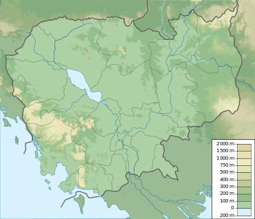 | |
| Location | Cambodia |
| Nearest city | Siem Reap |
| Coordinates | 13°36′22″N 104°05′45″E / 13.6062°N 104.0957°ECoordinates: 13°36′22″N 104°05′45″E / 13.6062°N 104.0957°E |
| Area | 375 km2 (145 sq mi)[1] |
| Established | 1993[1] |
Phnom Kulen National Park is a National park in Cambodia. It is located in the Phnom Kulen (Khmer: ភ្នំគូលេន) mountain massif in Siem Reap Province. During Angkorian era the relief was known as Mahendraparvata (the mountain of Great Indra) and was the place where Jayavarman II had himself declared chakravartin (King of Kings), an act which is considered the foundation of Khmer Empire.[2]
Archaeological sites
Phnom Kulen National Park is located in Svay Leu District about 48 km from the provincial town of Siem Reap and about 25 km from Prasat Banteay Srey via Charles De Gaulle Road. At Phnom Kulen there are several attractive places, such as:[3]
Chup Preah
Chup Preah (Khmer: ជប់ព្រះ) is the plain spot where having cool water flows and is located at the mountain’s valley. Next to it, there is a rare big tree of Cham Pa having 0.7 meter diameter and 15-meter height. At Chup Preah, there is a big Buddhist statue and many other small statues made during the 16th century.
Kbal Spean

The Kbal Spean archaeological site, also known as "Valley of a thousand Lingas" (Khmer: លឹង្គ១០០០), is located on the mountain, along the Kbal Spean River, which is tributary of Siem Reap River. The site has many figures of Yoni and Linga as well as other figures carved into the rocks of the riverbed and banks which may become fully exposed in the dry season when the river dries up. The river is shallow and small waterfalls form at the site in the wet season. The site is accessible by trekking uphill through a 1.5 km jungle track from the parking site.
Terrace of Sdach Kamlung
Terrace of Sdach Kamlung (Khmer: ព្រះលានស្តេចគំលង់) is a plain terrace with a small ruined temple made of bricks in the middle. The terrace was once covered with lava.
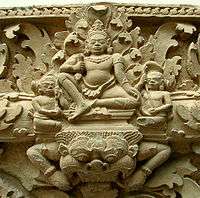
Preah Ang Thom

Preah Ang Thom (Khmer: ព្រះអង្គធំ) is an 8 meter tall statue of the reclining Buddha reaching nirvana. The statue is carved into a huge sandstone boulder. Preah Ang Thom is the sacred and worshipping god for Phnom Kulen. There are also two big trees of Cham Pa (Khmer: ដើមចំប៉ា) at nearby. Besides Preah Ang Thom, there are Chhok Ruot (Khmer: ឆ័តរួត), footprint of Preah Bat Choan Tuk (Khmer: បាតជើងព្រះបាទជាន់ទុក្ខ), Peung Chhok (Khmer: ពើងឆ័ត), Peung Ey So (Khmer: ពើងឥសូ) and Peung Ey Sey (Khmer: ពើងឥសី).
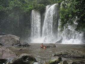
Waterfalls
There are two main waterfalls in Phnom Kulen (Khmer: ទឹកធ្លាក់ភ្នំគូលេន):
- First waterfall: 4-5 meter tall and around 25 meter wide during the rainy seasons.
- Second waterfall: 15-20 meter tall and around 15 meter wide during the rainy seasons.
The size of the waterfalls varies according to the seasons and the rain.
Archeological activities
After initial reconnaissances by French scholars, the historical relevance of Phnom Kulen was pointed out by Philippe Stern, who visited it in 1936 and described Rong Chen[4] as the first temple-mountain.[5][6] In 1973 and 1979 Jean Boulbet and Bruno Dagens published the fundamental archeological inventory and mapping of Phonm Kulen.[7][8] In 2008 Archaeology & Development Foundation begun Phnom Kulen Program,[9] an archaeological project focused even on sustainable development of local communities.
In June 2013, an archaeological team announced the discovery and mapping of the ancient city of Mahendraparvata on the slopes of Phnom Kulen. The multi-year expedition was notable for its use of Lidar technology to reveal the layout of the city from beneath jungle and earth. 30 previously unidentified temples have been discovered.[10]
References
- 1 2 "Phnom Kulen National Park". WCMC. Retrieved 2009-08-29.
- ↑ Higham, 2001: pp.54-59
- ↑ "Sightseeing Koulen Mountain". Cambodian government. 2003-11-19. Retrieved 2009-09-16.
- ↑ Rong Chen on CISARK site
- ↑ Stern, Philippe (1938). "Travaux exécutés au Phnom Kulên (15 avril-20 mai 1936)". BEFEO (in French). 38: 151–174. doi:10.3406/befeo.1938.4718. ISSN 0336-1519.
- ↑ Stern, Philippe (1938). "Le style du Kulên (décor architectural et statuaire)". BEFEO (in French). 38: 111–150. doi:10.3406/befeo.1938.4717. ISSN 0336-1519.
- ↑ Boulbet, Jean; Dagens, Bruno (1973). "Les sites archéologiques de la région du Bhnam Gulen (Phnom Kulen)". Arts Asiatique (in French) (XXVII).
- ↑ Boulbet, Jean (1979). Le Phnom Kulen et sa Région. Paris: École française d'Extrême-Orient.
- ↑ website of Phnom Kulen Program
- ↑ Murdoch, Lindsay (15 June 2013). "Lost horizons: mediaeval city uncovered". Sydney Morning Herald. Retrieved 15 June 2013.
Bibliography
- Rooney, Dawn F. (2005). Angkor: Cambodia's wondrous khmer temples (5th ed.). Odissey. ISBN 978-962-217-727-7.
- Higham, Charles (2001). The Civilization of Angkor. Phoenix. ISBN 1-84212-584-2.
External links
- page on Phnom Kulen from the official website of Kingdom of Cambodia
- AngkorGuide.Net
- PeaceOfAngkorWeb.com
- Andy Brouwer's blog on the less-visited angkorian temples of Phnom Kulen
- Andy Brouwer's blog on newest archeological activities in Phnom Kulen
- website of Phnom Kulen Program and a documentary on its activities
- Protected areas in Cambodia