Phoenix metropolitan area arterial roads
Many arterial roads in the Phoenix metropolitan area have the same name in multiple cities or towns. Some roads change names or route numbers across town borders, resulting in occasional confusion. For example, the road known as Apache Boulevard in Tempe continues east as Main Street in neighboring Mesa and then as Apache Trail in Apache Junction. Although Broadway Road maintains the same name through Goodyear, Avondale, Phoenix, Tempe, Mesa, and Apache Junction, each town uses a different reference point for address numbers.
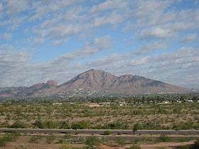
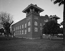
Baseline Road
-Welcome_to_Laveen-2.JPG)
Baseline Road is a significant east-west arterial road. This road is so named because it runs along the length of the primary baseline for Arizona as given under the Public Land Survey System.
This line runs east-west from the "zero point" atop a hill near the confluence of the Gila and Salt rivers, on Avondale Boulevard (115th Avenue) at Baseline Road. This site is next to Phoenix International Raceway. Avondale Boulevard is laid out atop the north-south base meridian, called the Gila and Salt River meridian.
Due to natural obstructions, this road is not continuous.The longest continuous stretch of the road is approximately 43 miles.The road is located in Maricopa County and Pinal County. There is also a rural road named Baseline Road in southern La Paz County close to the Colorado River which is located near Arizona's baseline.
Because of the grid plan used by cities in Arizona, the name for the road is applied for non-contiguous sections and is theoretically reserved for future east-west roads built at the same latitude.
Route description
Starting from east, the road begins in Apache Junction in Pinal County, named Baseline Avenue and is a small segment of thoroughfare in a residential neighborhood at the foothills of the Superstition Mountains. The route picks up again and runs due westward, running parallel to US 60. At the Maricopa County border, the road enters Mesa and is named Baseline Road. It becomes a major arterial road as it passes through Gilbert and Tempe. In Tempe, it intersects Loop 101 and then Interstate 10. Continuing, the road runs through south Phoenix and the major arterial segment of the road terminates in the Gila River Indian Community, approximately where the Salt River joins the Gila River.
The road reappears on the other side of the Gila River at an orthogonal junction with Perryville Rd. as CR-85 and continues westward through central Buckeye. From there, it continues through farmland in western Maricopa county in various non-continuous segments. The segment of Baseline Road furthest west in Maricopa County is just past 547th Avenue.
Due to the ease of navigation on this extremely long route, as well as the significant number of municipalities that the route encompasses, it is a favorite street for those electing not to use Phoenix's many freeways such as I-10 and US 60.
Landmarks
Notable locations along or near Baseline Road include Arizona Mills and Phoenix International Raceway. Baseline Road runs through the historical farming community of Laveen.
Bell Road

Bell Road is a major east-west arterial road in northern metropolitan Phoenix. Bell Road is one of the few roadways to cross the Agua Fria River in the northern part of the metro area, providing a vital link between the growing suburb of Surprise with Phoenix. As a result, the portion of Bell Road passing through Surprise and Sun City is the busiest arterial road in the state of Arizona.[1]
Route description
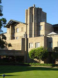
The main segment of Bell Road, approximately 31 miles (50 km) in length, begins at the corporate boundaries of Phoenix and Scottsdale at its intersection with Scottsdale Road; east of Scottsdale Road, the roadway curves to the southeast and becomes Frank Lloyd Wright Boulevard. Traveling west, the road intersects with State Route 51 and Interstate 17 in Phoenix, the western leg of State Route 101 in Peoria, and U.S. Route 60 and State Route 303 in Surprise. West of the Beardsley Canal, the roadway curves around the White Tank Mountain Regional Park, becoming the Sun Valley Parkway through northern Buckeye.
East of 66th Street, Bell Road takes a south-easterly bend and, at its intersection with Scottsdale Road, becomes Frank Lloyd Wright Boulevard, named in recognition of architect and designer Frank Lloyd Wright. This alignment was built in the mid-1970s during the construction of the CAP canal.[2] In this area of Scottsdale, a non-contiguous segment of Bell Road approximately 3 miles (4.8 km) long exists north of Frank Lloyd Wright Boulevard, which includes an intersection with the eastern leg of State Route 101.
Landmarks
Prominent locations on or near Bell Road include the Scottsdale Municipal Airport, Turf Paradise, Arrowhead Towne Center and the Peoria Sports Complex. Bell Road also forms the boundary of the original town site of Surprise.[3]
Camelback Road
Camelback Road is a prominent street in the metropolitan area.
The street stretches continuously for approximately 33 miles from Scottsdale in the east to Litchfield Park in the west, and in the process runs through the city of Phoenix. Scottsdale Fashion Square is located at the corner of Camelback and Scottsdale Roads.[4]
Camelback Road runs directly south of Phoenix's famous Camelback Mountain and the Phoenician Resort. Further west, the upscale Biltmore district of Phoenix is located along Camelback Road, including the Arizona Biltmore Hotel (just to the north), Biltmore Fashion Park, as well as one of Phoenix's primary business districts (sometimes called the Camelback Corridor).
In Litchfield Park, Camelback Road passes the historic Wigwam Resort, built in 1918.[5]
West of Litchfield Park, Camelback Road skirts the southern boundary of Luke Air Force Base.
Central Avenue
Central Avenue extends from South Mountain Park to North Mountain in Phoenix. The Central Avenue Corridor, roughly from Camelback Road to McDowell Road, is one of Phoenix's most heavily trafficked stretches of roadway. The Central Avenue Corridor bisects the area known as Midtown, Phoenix, a collection of neighborhoods north of Downtown and south of the North-Central and Sunnyslope areas.
For the most part, Central Avenue marks the "zero" point of east/west addresses in the Phoenix area.
Grand Avenue
The portion of U.S. Route 60 that enters Phoenix from the northwest Valley is known as Grand Avenue, a street which slices through west Phoenix at a 45-degree angle. This makes it instantly recognizable on any City of Phoenix map, and it represents the final leg of US 60 into the heart of Phoenix. Although US 60 departs Grand Ave. at an interchange with 27th Avenue, Grand Ave. itself continues southeast towards the intersection of 7th Avenue and Van Buren Street.
As of 2006, Lower Grand Avenue, between Roosevelt Street on the north and Van Buren Street on the south, has been experiencing a renaissance,[6] as art venues, bars, cafes and small businesses have emerged amid the work being done to restore historic properties, including decaying warehouses.
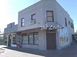
On the first and third Fridays of every month, Grand Avenue hosts cultural events. Some of the venues associated with the Grand Avenue art scene include the Trunk Space, the Lodge Art Parlor, ShopDevious, the Icon Gallery, the Chocolate Factory, the Paisley Violin, La Melgosa Complex: Deus Ex Machina, the Phoenix Fall Space, Stop n' Look & Comet's Corner, the Annex: Soul Invictus, the Lucky Rabbit & Gallery Marsiglia, Lady Luck Tattoo, and other design houses and studios.
As a result of this revitalization the Grand Avenue Merchants Association (GAMA) formed to address a "Grand New Vision" and to bring the Grand Avenue community together with other neighborhood associations to form an arts, culture and small business district with a mind towards adaptive reuse of historical buildings, infill projects and both small business and community based outreach.
In 2011, the City of Phoenix was chosen as one of five U.S. capitals to receive federal design assistance through the U.S. Environmental Protection Agency (EPA) Greening America’s Capitals program, with the goal of creating a more environmentally and economically sustainable design along the lower Grand Avenue corridor.[7]
Indian School Road

Indian School Road runs continuously east/west for approximately 41 miles with the Salt River Pima-Maricopa Indian Community at the east end and Buckeye & Maricopa County White Tank Mountain Regional Park at the west end. It intersects with Arizona State Route 51, Arizona State Route 101, Interstate 17, US 60/Grand Avenue and Arizona State Route 303. Though running predominantly through the metro Phoenix area, Indian School Road does continue west of the White Tank Mountains from approximately 27600 West to 41100 West (411th Avenue being an overpass and access to Tonopah and Interstate 10) to 46700 West, and from 48700 West to Harquahala Valley Road (52000 West).
Indian School Road was named in territorial days as the road to the Phoenix Indian School (1890-1991) located on the site of the present Steele Indian School Park.[8][9][10]
Landmarks
- Arcadia High School 4703 East. Past students include Steven Spielberg, Lynda Carter and Astronaut Bill Shepherd.
- Carl Hayden Veterans Administration Medical Center, 650 East, named after Arizona's first Representative (1912-1927) and US Senator from Arizona (1927-1969) succeeded by Barry Goldwater.
- Steele Indian School Park, 300 East. Original site of the Phoenix Indian School; there are historical buildings that were once part of the Indian School campus, specifically the Dining Hall, built in 1902, and Memorial Hall, built in 1922. More recently, this was the site of a fatal helicopter crash on July 27, 2007 when KTVK and KNXV choppers collided during a police chase, and wreckage landed in the park.[11]
- Phoenix Air Haven Airport, 2700-3300 West, was located on the south side of the road from 1945 to 1960. It is now an industrial office complex.[12][13]
- Maryvale Mall 5100 West. Now closed, the site consists of two schools (an elementary and a middle) utilizing former buildings of the mall. A nearby Super Wal-mart was built with a new structure.[14]
Mill Avenue

Mill Avenue is a historic street in Tempe. In north Tempe near Arizona State University, the street runs through a popular, pedestrian-friendly shopping and nightlife district. Mill Avenue was originally centered around the Hayden Flour Mill, which, while disused, still stands on the north end of the Avenue. Today, the avenue plays host to many bars, designer shopping stores, as well as many fairs, and city festivals. It was described in 2010 by a New York Times reporter as "a bohemian commercial strip next to Arizona State University".[15]
At the northern end of the shopping district, the two Mill Avenue bridges cross the Salt River at Tempe Town Lake. One bridge was completed in 1931, the other in 1994.
History
After the founding of Fort McDowell on the east side of central Arizona’s Salt River Valley in 1865, farmers moved into the area. These early settlers further developed the irrigation canals that the Hohokam people originally created and built new ones to carry Salt River water to their farms. Agriculture in the Salt River valley soon gave food to Arizona’s military posts and mining towns. In 1871, Hiram C. Hodge commented that there were two stores and a population of about 100 in Tempe.[16]
A substantial addition to the Tempe economy was established in 1877, when Charles T. Hayden, a business man from Connecticut,[17] opened a flour-mill operation that was supplied with water from the Tempe Irrigating Canal. Charles T. Hayden, and his family operated the mill for three full generations, and it was crucial to Tempe's community industry.[16]
Also in 1877, Charles' son Carl Hayden, who was to become a congressman and then senator from Arizona, was born in the Hayden family home, a building which is still a landmark on Mill Avenue today, now known as the western steakhouse Monti's La Casa Vieja ("The Old House").[18]
The Hayden's Ferry Post Office was renamed the Tempe Post Office in 1879. In 1889, the new Phoenix and Maricopa Railroad linked Tempe with Phoenix. In 1894, the Maricopa County Board of Supervisors incorporated the town of Tempe. Tempe finally became a city after being inhabited for over 30 years.[16]
In 1962, the Laird and Dines Drug Store closed after 68 years of operation at the corner of Mill Avenue and Fifth Street. This drug store was one of the original fixtures on the commercial district of Mill Avenue. Tempe’s commercial center along Mill Avenue declined during these years.
In 1964, construction of the Grady Gammage Memorial Auditorium, designed by Frank Lloyd Wright, was completed at the intersection of Mill Avenue and Apache Boulevard on the campus of Arizona State University.
Prompted by Tempe’s centennial in 1971, Mill Avenue was revitalized into an entertainment and shopping district that attracts people from throughout the Phoenix Valley.[16]
In 1997, the Hayden Flour Mill closed after 123 years of continuous operation. The mill's last operator was Bay State Milling, which had purchased it in 1981. It is significant as the oldest continuously used industrial site in the Salt River Valley.[16]
Theaters

The Valley Art Theater (operated by Harkins Theatres) is located on Mill Avenue as a comfortable single screen theater that typically shows art house and occasionally foreign films. The current building was built in 1938, although it underwent substantial internal renovations in the 1990s.
AMC Centerpoint, an 11-screen complex, is also located on the avenue. It was originally owned by Harkins; however, with the completion of the Tempe Marketplace, which provided a more modern building, Harkins closed it in January 2008.[19] AMC reopened the Centerpoint in April 2014.[20]
Sun Valley Parkway
Sun Valley Parkway is mainly located in Buckeye, with a small portion extending into Surprise, Arizona.
Built in the 1980s, the four-lane divided parkway traverses approximately 30 miles of what was once open desert about 35 miles west of downtown Phoenix. It extends north–south from Interstate 10 at exit 109 (Sun Valley Parkway / Palo Verde Road) in Buckeye, turns after about 12 miles or so to become an east–west road, and leads eastward to Surprise, where the road connects to and becomes Bell Road through Surprise and other West Valley suburbs (and eventually the City of Phoenix itself).
Developments
There are a number of master-planned communities located along this roadway in Buckeye (after no development in the area for several years after the road was built). Currently being built are Tartesso and Sun City Festival. Other communities in the planning stages include Sun Valley, Sun Valley South, Spurlock Ranch, Elianto, Trillium in Buckeye and Douglas Ranch.
See also
References
- ↑ Turner, Erin (2009-12-15). "Homeowners offer mixed reactions to El Mirage Road addition". Daily News-Sun. Retrieved 2010-01-04.
- ↑ http://www.historicaerials.com/aerials.php?javascript=1&scale=622&lon=-111.92868476269031&lat=33.63777377029446&year=1970
- ↑ "Surprise Original Town Site" (PDF). City of Surprise.
- ↑ Scottsdale Fashion Square | Location
- ↑ http://www.wigwamresort.com/
- ↑ Negrete, Lauren (September 2, 2014). "Two Phoenix events combine festivities to promote arts and local business".
- ↑ Remillard, Mark (April 18, 2014). "Grand Avenue's new look has business benefits".
- ↑ http://www.whitebison.org/wellbriety-journey/PhoenixIndianSchool.htm
- ↑ http://www.phoenixmag.com/lifestyle/history/200908/indian--boarding--school-road/
- ↑ http://www.bradhallart.com/phoenix_streets.htm
- ↑ http://www.hollywoodreporter.com/hr/content_display/news/e3i740157b4a6e7f1502493edd69ad6681e. Missing or empty
|title=(help) - ↑ http://brazilbrazil.com/ports.html
- ↑ http://www.airfields-freeman.com/AZ/Airfields_AZ_Phoenix_NW.htm#airhaven
- ↑ https://news.google.com/newspapers?id=amgLAAAAIBAJ&sjid=OVMDAAAAIBAJ&pg=6828,2313175&dq=maryvale+mall+phoenix&hl=en
- ↑ "Republican Runs Street People on Green Ticket" article by Marc Lacey in The New York Times September 6, 2010, accessed September 7, 2010
- 1 2 3 4 5 Sheppard, Chris. "A Rich History". Retrieved 2008-11-02.
- ↑ Bio: Charles Trumbull Hayden - Tempe, Arizona
- ↑ http://www.montis.com/history.php
- ↑ McLellan, Sarah (4 January 2008). "Harkins to close Centerpoint theater Sunday". Arizona Republic. azcentral.com. Retrieved 28 April 2015.
- ↑ Moo, Juliet (9 September 2014). "AMC Centerpoint a jewel on Mill". The State Press. Retrieved 28 April 2015.