Litchfield Park, Arizona
| Litchfield Park, Arizona | ||
|---|---|---|
| City | ||
| ||
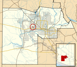 Location in Maricopa County and the state of Arizona | ||
 Litchfield Park, Arizona Location in the United States | ||
| Coordinates: 33°29′36″N 112°21′30″W / 33.49333°N 112.35833°WCoordinates: 33°29′36″N 112°21′30″W / 33.49333°N 112.35833°W | ||
| Country | United States | |
| State | Arizona | |
| County | Maricopa | |
| Government | ||
| • Mayor | Thomas L. Schoaf | |
| Area | ||
| • Total | 3.1 sq mi (8.1 km2) | |
| • Land | 3.1 sq mi (8.1 km2) | |
| • Water | 0.0 sq mi (0.0 km2) | |
| Elevation | 1,030 ft (314 m) | |
| Population (2010)[1] | ||
| • Total | 5,476 | |
| • Estimate (2014)[2] | 5,392 | |
| • Density | 1,459.0/sq mi (558.4/km2) | |
| Time zone | MST (no DST) (UTC-7) | |
| ZIP code | 85340 | |
| Area code(s) | 623 | |
| FIPS code | 04-41330 | |
| Website | http://www.litchfield-park.org/ | |

Litchfield Park is a city in Maricopa County, Arizona, United States. It is twenty miles northwest of Phoenix. According to the 2010 census, the population of the city is 5,476.[1]
History

The town of Litchfield Park is named for its founder, Paul Weeks Litchfield (1875-1959). He was an executive of the Goodyear Tire & Rubber Company who came to the Phoenix area in 1916 in search of suitable land to farm a long-staple cotton that had previously been available only from the Sea Islands off the coast of Georgia and from Egypt. This cotton was needed to strengthen the rubber in the pneumatic tire, of which Goodyear was the world's largest producer. The east coast cotton supply had been devastated by the boll weevil and the African supply had been greatly reduced by World War I attacks from German U-boats. Litchfield went to the Phoenix area at the suggestion of the United States Department of Agriculture, but he was not successful in motivating local farmers to grow his cotton. Instead he got Goodyear to form the Southwest Cotton Company in Phoenix, with Litchfield as its president, eventually purchasing some 36,000 acres in the general Salt River Valley area including 5,000 acres around the present site of Litchfield Park, then known as Litchfield Ranch. Much of the land was bought for as little as $25 per acre. The cotton was cultivated with a workforce of mostly Mexican and Native American men. The U.S. Postal Service agreed to the name "Litchfield Park" in 1926. In 1929, the Wigwam Resort was opened to the public. In 1926, Litchfield went on to become the president of the Goodyear-Zeppelin Corporation,[3] and then Chairman of the Board in 1930. He retired from the company in 1958, and spent the final months of his life as a resident of Litchfield Park at his home on Fairway Drive.[4]
In 1964, Goodyear created Litchfield Park Land and Development Co. to expand Litchfield Park into 90,000 resident community.[5][6] Arden E. Goodyear was the head of the company, Patrick Cusick was vice president and general manager, and Victor Gruen was hired to design some of the buildings. The plan called for 25,000 homes, a college, a junior college, eighteen elementary schools, ten junior high schools, and six high schools, as well as improvements to the town's golf course and harness track at an expense of at least 750 million dollars.[7] Goodyear made many mistakes during development, including selling properties right up to the curb line, which means that the city must get permission from property owners before they can put in a sidewalk. They abandoned their plans for expanding Litchfield Park before they were completed and sold whatever land they could.[8]
A nearby town is named Goodyear, and the Goodyear Blimp often operates in the area.
Geography
Litchfield Park is located at 33°29′36″N 112°21′30″W / 33.49333°N 112.35833°W (33.493410, -112.358210).[9]
According to the United States Census Bureau, the city has a total area of 3.1 square miles (8.0 km2), all of it dry land with the exception of a man made lake.
Demographics
| Historical population | |||
|---|---|---|---|
| Census | Pop. | %± | |
| 1970 | 1,664 | — | |
| 1980 | 3,657 | 119.8% | |
| 1990 | 3,303 | −9.7% | |
| 2000 | 3,810 | 15.3% | |
| 2010 | 5,476 | 43.7% | |
| Est. 2015 | 5,533 | [10] | 1.0% |
| U.S. Decennial Census[11] 2014 Estimate[2] | |||
Litchfield Park had a population of 5,476 at the 2010 census. The racial and ethnic composition of the population was 74.3% non-Hispanic white, 3.5% black or African American, 1.0% Native American, 4.1% Asian, 0.1% non-Hispanic from some other race, 2.8% two or more races and 15.4% Hispanic or Latino.[12]
Government
The Mayor is Tom Schoaf, the Vice Mayor is Paul Faith. City Council members are: Peter Mahoney, Paul Stucky, Tim Blake, John Romack and Jeff Raible.[13] The first Mayor was Charles Salem.
Education
[14] The Litchfield Elementary School District and the Agua Fria Union High School District serve Litchfield Park. Litchfield Elementary School District has some schools located in the city.
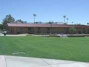
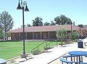
| Historic Litchfield Elementary School | ||||
|---|---|---|---|---|
|
Tourism
- Kiwanis Litchfield Park Winter Trout Fishing Derby
- Annual Wigwam Festival of Fine Art
- Arts in the Park Concert Series
- Flavors of the West Festival
- Litchfield Park Friends of the Rec 10k, 5k, 1 Mile Run/Walk
- Annual Spring Art & Culinary Festival
- Annual Sprint in the Park Triathlon
- Annual Wigwam Amateur Championship hosted by the City of Litchfield Park
- Memorial Day Ceremony
- "Splash Bash"
- Independence Day Fireworks Celebration
Notable people
- Ray King, Former MLB relief pitcher
- Warren A. Morton, Wyoming oilman and former Speaker of the Wyoming House of Representatives
- Jacque Mercer, Former Miss America
References
- 1 2 "American FactFinder". United States Census Bureau. Retrieved 2014-06-18.
- 1 2 "Population Estimates". United States Census Bureau. Retrieved July 11, 2015.
- ↑ TIME Magazine Cover Story
- ↑ A History of Litchfield Park
- ↑ "Rubber Firm Hiring Cusick". The Pittsburgh Press. June 25, 1964. Retrieved 20 June 2012.
- ↑ "Planner Here Going West". The Pittsburgh Press. June 24, 1964. Retrieved 20 June 2012.
- ↑ "22 Miles Of Arizona Luring Cusick From Planning Job Here". The Pittsburgh Press. August 16, 1964. Retrieved 20 June 2012.
- ↑ Madrid, David (April 27, 2012). "Decline of Scout Park angers Litchfield Park neighbor". The Republic. Retrieved 20 June 2012.
- ↑ "US Gazetteer files: 2010, 2000, and 1990". United States Census Bureau. 2011-02-12. Retrieved 2011-04-23.
- ↑ "Annual Estimates of the Resident Population for Incorporated Places: April 1, 2010 to July 1, 2015". Retrieved July 2, 2016.
- ↑ "U.S. Decennial Census". Census.gov. Retrieved June 18, 2014.
- ↑ 2010 census chart for Litchfield Park
- ↑ "Official Web Site of the City of Litchfield Park". Litchfield Park, AZ. Retrieved 17 November 2015.
- ↑ http://www.litchfield-park.org/index.aspx?NID=722
External links
Municipalities and communities of Maricopa County, Arizona, United States | ||
|---|---|---|
| Cities |  | |
| Towns | ||
| CDPs | ||
| Unincorporated communities |
| |
| Indian reservations | ||
| Ghost towns | ||
| Footnotes | ‡This populated place also has portions in an adjacent county or counties | |