Phu Sing District
| Phu Sing ภูสิงห์ | |
|---|---|
| Amphoe | |
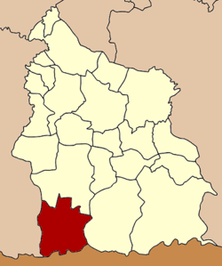 Amphoe location in Sisaket Province | |
| Coordinates: 14°32′48″N 104°7′54″E / 14.54667°N 104.13167°ECoordinates: 14°32′48″N 104°7′54″E / 14.54667°N 104.13167°E | |
| Country |
|
| Province | Sisaket |
| Seat | Huai Tuekchu |
| Area | |
| • Total | 940.1 km2 (363.0 sq mi) |
| Population (2005) | |
| • Total | 50,585 |
| • Density | 53.8/km2 (139/sq mi) |
| Time zone | THA (UTC+7) |
| Postal code | 33140 |
| Geocode | 3317 |
Phu Sing (Thai: ภูสิงห์) is a district (Amphoe) in the southwestern part of Sisaket Province, northeastern Thailand.
History
The minor district (King Amphoe) was created on April 1, 1991, when the six tambon Khok Tan, Huai Ta Mon, Huai Tuekchu, Lalom, Takhian Ram and Dong Rak were split off from Khunkhan district.[1] It was upgraded to a full district on September 8, 1995.[2]
Geography
The district is bound in the south by the Dangrek Range. Neighboring districts are (from the west clockwise) Buachet of Surin Province, Khukhan, Khun Han of Sisaket Province and Oddar Meancheay of Cambodia.
Administration
The district is subdivided into 7 subdistricts (tambon), which are further subdivided into 85 villages (muban). There are no municipal (thesaban) areas, and 7 Tambon administrative organizations (TAO).
| No. | Name | Thai name | Villages | Inh. | |
|---|---|---|---|---|---|
| 1. | Khok Tan | โคกตาล | 13 | 7,324 | |
| 2. | Huai Ta Mon | ห้วยตามอญ | 10 | 6,212 | |
| 3. | Huai Tuekchu | ห้วยตึ๊กชู | 18 | 11,313 | |
| 4. | Lalom | ละลม | 13 | 7,554 | |
| 5. | Takhian Ram | ตะเคียนราม | 14 | 5,928 | |
| 6. | Dong Rak | ดงรัก | 8 | 5,770 | |
| 7. | Phrai Phatthana | ไพรพัฒนา | 9 | 6,484 |
sa-ngam new town
Phu Sing is one of three district of Si Sa Ket province. The area adjacent to Cambodia The area has been developed as a source of trade, investment and tourism in the future by creating asa-ngam new town is a place for support to trade Exchange between the two countries and is the location of government agencies such as Transportation. Custom Channel and Office of Immigration.
sa-ngam New Town located at Phu Sing district, Sisaket province. Miles from the Cambodian border for a distance of 2 kilometers to the present has not been officially activated in any way.
References
- ↑ ประกาศกระทรวงมหาดไทย เรื่อง แบ่งเขตท้องที่อำเภอขุขันธ์ จังหวัดศรีสะเกษ ตั้งเป็นกิ่งอำเภอภูสิงห์ (PDF). Royal Gazette (in Thai). 108 (15 ง): 1069. January 31, 1991.
- ↑ พระราชกฤษฎีกาตั้งอำเภอด่านมะขามเตี้ย อำเภอแก่งหางแมว อำเภอภักดีชุมพล อำเภอเวียงแก่น อำเภอแม่วาง อำเภอถ้ำพรรณรา อำเภอบ่อเกลือ อำเภอโนนสุวรรณ อำเภอห้วยราช อำเภอแม่ลาน อำเภอบางแก้ว อำเภอป่าพะยอม อำเภอหนองม่วงไข่ อำเภอยางสีสุราช อำเภอจังหาร อำเภอบ้านธิ อำเภอภูสิงห์ อำเภอบางกล่ำ อำเภอวังม่วง และอำเภอนายูง พ.ศ. ๒๕๓๘ (PDF). Royal Gazette (in Thai). 112 (32 ก): 1–3. August 8, 1995.