Picinisco
| Picinisco | |
|---|---|
| Comune | |
| Comune di Picinisco | |
 | |
 Picinisco Location of Picinisco in Italy | |
| Coordinates: 41°39′N 13°52′E / 41.650°N 13.867°ECoordinates: 41°39′N 13°52′E / 41.650°N 13.867°E | |
| Country | Italy |
| Region | Lazio |
| Province / Metropolitan city | Frosinone (FR) |
| Frazioni | Borgo Castellone, Fontitune, L'Antica, Liscia, Rocca degli Alberi, San Gennaro, San Giuseppe, Valle Porcina |
| Government | |
| • Mayor | Marco Scappaticci |
| Area | |
| • Total | 62.2 km2 (24.0 sq mi) |
| Elevation | 725 m (2,379 ft) |
| Population (2008)[1] | |
| • Total | 1,250 |
| • Density | 20/km2 (52/sq mi) |
| Time zone | CET (UTC+1) |
| • Summer (DST) | CEST (UTC+2) |
| Postal code | 03040 |
| Dialing code | 0776 |
| Patron saint | San Lorenzo |
| Website | Official website |
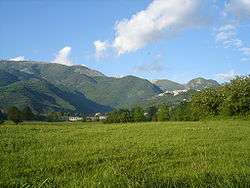
Picinisco is a comune (municipality) in the Province of Frosinone in the Italian region Lazio, located about 120 kilometres (75 mi) east of Rome and about 45 kilometres (28 mi) east of Frosinone. It is included in the Valle di Comino and National Park of Abruzzo, Lazio e Molise.
History
Picinisco was already inhabited, by Sabellian peoples, before it was subsumed into the expanding Roman empire over two thousand years ago. The first surviving written record of Picinisco dates from the middle of the 12th century, when King Roger II of Sicily defined through a decree the territorial limits of the adjacent town of Atina. From then until 1806, Piciniso belonged to the Duchy of Alvito, a fiefdom within the Kingdom of Naples, and later on was part of the Kingdom of the Two Sicilies. During the Italian unification process, Picinisco became part of the Kingdom of Italy in 1861.