Georgia State Route 237
| ||||
|---|---|---|---|---|
| Piedmont Road NE | ||||
 | ||||
| Route information | ||||
| Maintained by GDOT | ||||
| Length: | 3.2 mi[1] (5.1 km) | |||
| Existed: | 1946[2][3] – present | |||
| Major junctions | ||||
| South end: | Piedmont Road NE in Midtown Atlanta | |||
|
| ||||
| North end: |
| |||
| Location | ||||
| Counties: | Fulton | |||
| Highway system | ||||
| ||||

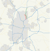
State Route 237 (SR 237) is a short state highway located in the Atlanta metropolitan area in the U.S. state of Georgia. It runs for approximately 3.2 miles (5.1 km) entirely within Fulton County.
Route description
SR 237 begins just south of SR 13 (Buford Highway) in Midtown Atlanta, where the road continues to the south as Piedmont Road. It immediately crosses under, but does not intersect Buford Highway. Then, it passes under Interstate 85 (I-85). SR 237's northbound lanes do not have an interchange with I-85. Its southbound lanes have an interchange with I-85 south. However, access to I-85 north is provided via an interchange with Piedmont Road NE, south of SR 237's southern terminus. North of I-85, the road crosses over a CSX Transportation rail line. It heads north and northwest to SR 141 (Peachtree Road SW). The highway heads northwest to meet its northern terminus, an intersection with US 19/SR 9 (Roswell Road) in North Buckhead. SR 237 is known as Piedmont Road NE for its entire length.[1]
No section of SR 237 is part of the National Highway System, a system of routes determined to be the most important for the nation's economy, mobility and defense.[4]
History
SR 237 was established at the latest by 1946 along an alignment that started at US 23, which ran along Chesire Bridge Road and a southern continuation of Piedmont Road NE at that time. This is just south of the current southern terminus. SR 237 headed north along Piedmont Road NE as it does today.[2][3] In 1967, US 23 was moved farther to the east. However, it is not clear whether the portion of SR 237 between the former US 23 segment and its current southern terminus was decommissioned at this time.[5][6]
Major intersections
The entire route is in Fulton County.
| Location | mi[1] | km | Destinations | Notes | |
|---|---|---|---|---|---|
| Midtown Atlanta | 0.0 | 0.0 | Piedmont Road NE | Southern terminus; roadway continues as Piedmont Road NE, which is a former section of SR 237. | |
| 0.1 | 0.16 | No access to I-85 is provided via the northbound lanes; access to I-85 north is just south of the southern terminus. | |||
| Buckhead | 2.2 | 3.5 | |||
| North Buckhead | 3.2 | 5.1 | Northern terminus; roadway continues as Blackland Road NW. | ||
| 1.000 mi = 1.609 km; 1.000 km = 0.621 mi | |||||
See also
-
.svg.png) Georgia (U.S. state) portal
Georgia (U.S. state) portal -
 Atlanta portal
 -
 U.S. Roads portal
 - Transportation in Atlanta
References
- 1 2 3 Google (February 25, 2013). "Route of SR 237" (Map). Google Maps. Google. Retrieved February 25, 2013.
- 1 2 Georgia State Highway System (PDF) (Map). Cartography by GSHD. Georgia State Highway Department. January 1, 1945. Retrieved February 25, 2013.
- 1 2 Georgia State Highway System (PDF) (Map). Cartography by GSHD. Georgia State Highway Department. November 7, 1946. Retrieved February 25, 2013.
- ↑ "National Highway System: Georgia" (PDF). United States Department of Transportation. May 8, 2009. Retrieved February 17, 2013.
- ↑ Georgia State Highway System (PDF) (Map). Cartography by GSHD. Georgia State Highway Department. January 1, 1967. Retrieved February 25, 2013.
- ↑ Georgia State Highway System (PDF) (Map). Cartography by GSHD. Georgia State Highway Department. January 1, 1968. Retrieved February 25, 2013.