Pine Hills, Atlanta

Pine Hills is a neighborhood of Atlanta, Georgia and also part of the Buckhead Community, located in north east Atlanta on the eastern part of Buckhead. It is roughly bounded by Buford Highway to the south, the railway (alongside East Paces Ferry Road) to the north, Lenox Road to the west and East Roxboro Road to the east. The western and central section of Pine Hills is in Fulton County and a smaller section to the east is in Dekalb County, east of a north-south line that roughly passes through the intersection of East Roxboro Road and West Roxboro Road. The area includes part of the 30324 and 30329 postal zip codes.
Geography

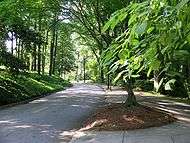
The area has several creeks and small streams. Indian Creek runs south and joins Peachtree Creek (north fork) which runs through the southern edge of the area. The area is hilly with some steep roads and driveways. Elevation varies by about 160 feet. The area has abundant plant life. It has many tall trees, such as pine, oak and maple. The area is home to wild animals such as squirrels, chipmunks and a wide variety of birds.
History
The Creek Indians lived in the surrounding area [1] and ceded their claim to the lands in this area in the early 19th century. The land was surveyed and split into counties and districts. In 1821 the land lots were distributed by lottery. One of the early families lived on the hill east of Shady Valley park and operated a saw mill on Peachtree Creek between 1857 and 1865. A corn and wheat mill on the north fork of Peachtree Creek was operated between 1885 and about 1910. The area was a quiet farming community until the early 20th century when Atlantans began moving out of the city to country estates, such as Roxborough Springs, the Standard Club (with golf course) and a riding academy in the Canter Road area. Further subdivisions were made in the 1930s. After World War II developers began dividing the rest of the area, building most of the homes that now exist.[2]
Neighboring amenities
The Lenox Square shopping mall is adjacent to north west corner of Pine Hills.
External links
References
- ↑ Franklin M. Garrett, "Atlanta and Environs," 1954
- ↑ Pine Hills History by Albert Martin
Coordinates: 33°50′13″N 84°21′07″W / 33.837°N 84.352°W