Pipestem Dam
| Pipestem Dam | |
|---|---|
 | |
 Location of Pipestem Dam in North Dakota | |
| Country | United States |
| Location | Stutsman County, near Jamestown, North Dakota |
| Coordinates | 46°57′41″N 98°45′6″W / 46.96139°N 98.75167°WCoordinates: 46°57′41″N 98°45′6″W / 46.96139°N 98.75167°W |
| Status | Operational |
| Construction began | 1971 |
| Opening date | 1973 |
| Owner(s) | U.S. Army Corps of Engineers |
| Dam and spillways | |
| Type of dam | Embankment |
| Impounds | Pipestem River |
| Height (thalweg) | 107.5 ft (33 m) |
| Length | 4,000 ft (1,219 m) |
| Reservoir | |
| Creates | Pipestem Reservoir |
| Total capacity | 8,944 acre·ft (11,032,262 m3) |
| Catchment area | 594 mi (956 km) |
| Max. length | 5.5 mi (9 km) |
| Max. water depth | 30 ft (9 m) |
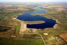
Pipestem Dam is an embankment dam on the Pipestem River located 4 mi (6 km) north of Jamestown, North Dakota. The dam was constructed for flood control, habitat conservation and recreation. Construction began in June 1971 and the dam was complete in 1973.[1]
See also
References
- ↑ "Pipestem Dam & Lake". U.S. Army Corps of Engineers. Retrieved 19 June 2011.
This article is issued from Wikipedia - version of the 9/21/2015. The text is available under the Creative Commons Attribution/Share Alike but additional terms may apply for the media files.