Gavins Point Dam
| Gavins Point Dam | |
|---|---|
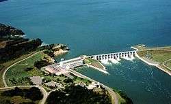 The power house and concrete section of the dam | |
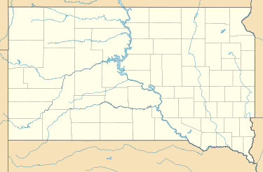 Location of Gavins Point Dam in South Dakota | |
| Country | United States |
| Location | Yankton County, South Dakota / Cedar County, Nebraska, near Yankton, South Dakota |
| Coordinates | 42°51′43″N 97°29′06″W / 42.86194°N 97.48500°WCoordinates: 42°51′43″N 97°29′06″W / 42.86194°N 97.48500°W |
| Status | Operational |
| Construction began | 1952 |
| Opening date | 1957 |
| Owner(s) | U.S. Army Corps of Engineers |
| Dam and spillways | |
| Type of dam | Embankment, rolled-earth and chalk-fill |
| Impounds | Missouri River |
| Height | 74 ft (23 m) |
| Length | 8,700 ft (2,652 m) |
| Width (crest) | 35 ft (11 m) |
| Width (base) | 850 ft (259 m) |
| Dam volume | 7,000,000 cu yd (5,351,884 m3) |
| Reservoir | |
| Creates | Lewis and Clark Lake |
| Total capacity | 492,000 acre·ft (606,873,064 m3) |
| Catchment area | 279,480 sq mi (723,850 km2) |
| Surface area | 31,400 acres (12,700 ha) |
| Max. length | 25 mi (40 km) |
| Max. water depth | 45 ft (14 m) |
| Power station | |
| Turbines | 3 x 44 MW |
| Installed capacity | 132 MW |
| Annual generation | 727 million KWh[1] |

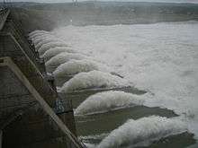
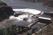
Gavins Point Dam is a hydroelectric dam on the Missouri River in the U.S. states of Nebraska and South Dakota. Built from 1952 to 1957, it impounds Lewis and Clark Lake. The dam is on the Nebraska-South Dakota border, west of Yankton, South Dakota. During the 2011 Missouri River Flood the dam was damaged by debris and a significant portion of rocks were dislodged from its upstream side. The U.S. Army Corps of Engineers soon began repairs the dam and its spillway gates. Pressure sensors were also installed in concrete portion of the dam.[3]
Gavins Point Dam is the lowermost dam on the Missouri, and was built as part of the Pick-Sloan Plan. The dam area (with Lewis and Clark Lake) is a very popular regional tourist destination.[4] The next dam upstream is the Fort Randall Dam.
The stretch of the Missouri immediately downstream of Gavins Point Dam is the only significant section of non-channelized meandering stream on the lower portion of the river. This federally designated Wild and Scenic River is among the last free-flowing stretches of the Missouri; it exhibits the islands, bars, chutes, and snags that once characterized the "Mighty Mo".
The dam has a hydroelectric plant with three generators, each having a nameplate capacity of 44,099 kW, for a total of 132.297 MW.[5]
See also
- Missouri National Recreational River
- Calumet Bluff, the Lewis & Clark encampment on the South side of the dam
References
- ↑ "Summary of Engineering Data – Missouri River Main Stem System" (PDF). Missouri River Division. U.S. Army Corps of Engineers. August 2010. Retrieved 2012-08-17.
- ↑ http://www.columbiamissourian.com/stories/2011/06/01/record-precipitation-reservoir-releases-cause-missouri-river-flooding/
- ↑ "Crews repair Gavins Point Dam from 2011 flooding". Black Hills Pioneer. 19 September 2013. Retrieved 19 September 2013.
- ↑ "Gavins Point Dam". Geographic Names Information System. United States Geological Survey. Retrieved 2006-05-10.
- ↑ "Gavins Point Dam & Powerplant". United States Army Corps of Engineers. 2008-10-24. Retrieved 2009-01-27.
External links
![]() Media related to Gavins Point Dam at Wikimedia Commons
Media related to Gavins Point Dam at Wikimedia Commons
Dams on the Missouri River | ||
|---|---|---|
 | ||