Plieningen
| Plieningen | ||
|---|---|---|
| Stadtbezirk of Stuttgart | ||
|
Town hall | ||
| ||
 Plieningen | ||
Location within Stuttgart 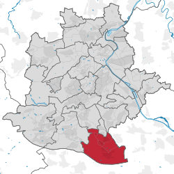 | ||
| Coordinates: 48°42′3.6″N 9°12′38.52″E / 48.701000°N 9.2107000°ECoordinates: 48°42′3.6″N 9°12′38.52″E / 48.701000°N 9.2107000°E | ||
| Country | Germany | |
| State | Baden-Württemberg | |
| Admin. region | Stuttgart | |
| District | Stuttgart | |
| City | Stuttgart | |
| Borough |
Asemwald Chausseefeld Hohenheim Steckfeld | |
| Founded | April 1, 1942 | |
| Government | ||
| • Bezirksvorsteherin | Andrea Lindel[1] (CDU) | |
| Area | ||
| • Stadtbezirk of Stuttgart | 13.07 km2 (5.05 sq mi) | |
| • Metro | 11.039 km2 (4.262 sq mi) | |
| Population (2011) | ||
| • Metro | 12,512 | |
| Time zone | CET/CEST (UTC+1/+2) | |
| Postal codes | 70599 | |
| Dialling codes | 0711 | |
| Vehicle registration | S | |
| Website |
stuttgart | |


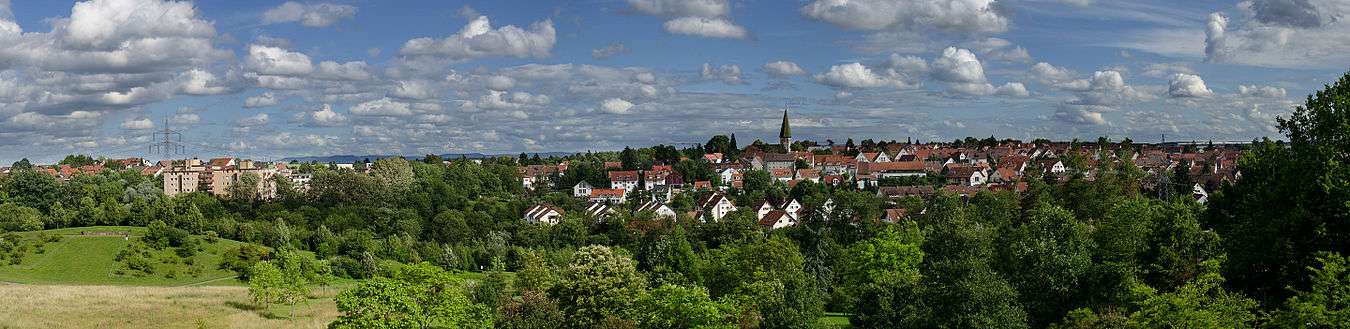
Plieningen (pronunciation: /pliːnɪnɡɛn/) is the southernmost municipality of Stuttgart in the state of Baden-Württemberg. Plieningen is located about 10 kilometres (6.2 mi) from the city center of Stuttgart on the Filder Plain. Schloss Hohenheim, part of the Stuttgart Airport, and the parking garage for the Stuttgart Trade Fair are located here.
Geography
Plieningen has five boroughs that altogether make up Plieningen's area of 1,307 hectares (13.07 km2).[2]
Municipalities
| No. | District | Population (2011) | area |
|---|---|---|---|
| 571 | Asemwald | 1,525 | 14.2 hectares (0.142 km2) |
| 552 | Chausseefeld | 1,165 | 6.9 hectares (0.069 km2) |
| 581 | Hohenheim | 575 | 156.3 hectares (1.563 km2) |
| 551 | Plieningen | 12,512 | 1,103.9 hectares (11.039 km2) |
| 561 | Steckfeld | 2,147 | 26.2 hectares (0.262 km2) |
History
The first settlers in the area appear to have been the Romans, as a Roman column depicting Jupiter was found buried under a farm along the Körsch River. The old military roads (Steinernes Kreuz (German: Stone cross)) were first built by Roman hands.
In AD 600, the first crude iteration of the Church of Saint Martin was constructed here from wood. In the 12th Century, one Hugo of Plieningen took the cross and joined the Fourth Crusade, and the device he chose for himself was 3 white roses on a field of blue, today Plieningen's Coat of Arms. Starting in the 12th and 13th Century, House Plieningen ruled Plieningen from Burg Plieningen. The oldest commercial operation of the Plieningens is the Upper Seemühle, which dates back to the 12th century in the Körschtal (German: Körsch valley).
In 1747, the Old Town Hall at Mönchhof was constructed. Later, in 1770, Duke Charles Eugene of Württemberg constructed Schloss Hohenheim from an old moated castle. On April 1, 1942, Plieningen and Birkach were accepted into Stuttgart as districts and neighborhoods.
When the districts of Stuttgart were divided in 1956, Plieningen was divided into three boroughs: Plieningen, Hohenheim, and Steckfeld. In 2001, all five boroughs of Plieningen were established.
Attractions

- Schloss Hohenheim – Old residence of Duke Charles Eugene. Features a zoological museum, and Tiermedizinischem
- University of Hohenheim – Surrounded by the Landesarboretum (German: Exotic garden) and Hohenheim Botanical Gardens, the German Agricultural Museum, and the Museum of the History of Hohenheim.
- Heimatmuseum Plieningen – until 2009 at the Old Town Hall, since May 2015 the Zehntscheuer.
- Church of Saint Martin – An early 12th Century stone monument of Plieningen.[3]
- Steinernes Kreuz (German: Stone cross) – Neuhauser Street and Echterdinger Road.
- Mönchhof – The old town hall. Now a museum.
- Körschtal (with the Upper and Lower Mill and the Mühlensee) (German: Körsch valley)
Politics
The District Advisory Board of Plieningen operate on the basis of the population of the municipalities of 12 ordinaries and as many alternates. These are the results of the last local elections in 2014:
- CDU: 3
- B90 / Greens: 3
- SDP: 2
- FDP: 1
- AFD: 1
Transportation
Two country roads connect Plieningen to Bundesautobahn 8 (Karlsruhe-Munich), Bundesstraße 27 (Stuttgart-Tübingen), Stuttgart Airport, and the Stuttgart Trade Fair.
Plieningen is the final stop on the U3 line on the Stuttgart Stadtbahn (Plieningen – Möhringen – Vaihingen). It operates on former Stuttgart-Möhringen Stuttgart-Hohenheim line and was opened in 1888 by the Filderbahn Society.
Sports
Turnverein Plieningen 1873, founded in 1873, has about 1300 members including about 900 in the gymnastics department.[4]
Notable residents
- Helisaeus Roeslin (1545–1616) – Physician, astrologer, and geographer chronologist
- Christian Gottlieb Göz (1746–1803) – Pastor in Plieningen and Hohenheim
Trivia
- Plieningen's Saint Martin's Church is one of the oldest churches in the Filder.
References
Bibliography
- Lunke, Oerny B. (2013). Plieningen, Hohenheim, Birkach. Bebildert mit GPS Standortangaben : Plieningen, Hohenheim, Birkach, Ridenberg. Ortsbeschreibung aus Kirchenbüchern und Oberamtsbeschreibungen Pf. Mezger 1903. Stuttgart: Atelier Lunke TY Culture. ISBN 978-3-931074-14-2.
- Lunke, Oerny B. (2013). Röslesland 2: "Historische Ortsansichten 1" – Foto Plieningen, Hohenheim, Birkach. Bebildert mit GPS Standortangaben : Historische Aufnahmen. Stuttgart: Atelier Lunke TY Culture. ISBN 978-3-931074-15-9.
- Lunke, Oerny B. (2014). Röslesland 3: Bildband "Historisch Mobil" – Plieningen, Hohenheim, Birkach. Autos, Kutsche, Motorräder, Fahrräder teils mit GPS Standortangaben : Plieningen, Hohenheim, Birkach, Riedenberg, Historische Fahrzeuge. Stuttgart: Atelier Lunke TY Culture. ISBN 978-3-931074-16-6.
- Lunke, Oerny B. (2014). Röslesland 4: Bildband "Heimat und Familien 1" – Plieningen, Hohenheim, Birkach. Historisch alte Familienaufnahmen 1850–1930 sowie Stammbäume. Stuttgart: Atelier Lunke TY Culture. ISBN 978-3-931074-17-3.
- Lunke, Oerny B. (2014). Röslesland 5: Bildband "Luftbildaufnahmen Röslesland" – Plieningen, Hohenheim, Birkach. Historisch Aufnahmen im vergleich zu Heute, mit Doppelseitigen Panorama Luftbildaufnahmen, 70 Fotos und Grafiken, die ältesten von 1918. Stuttgart: Atelier Lunke TY Culture. ISBN 978-3-931074-18-0.
- Breymayer, Reinhard (1985). Der endlich gefundene Autor einer Vorlage von Schillers "Taucher": Christian Gottlieb Göz (1746–1803), Pfarrer in Plieningen und Hohenheim, Freund von Philipp Matthäus Hahn?. Blätter für württembergische Kirchengeschichte 83/84 (1983/1984). Stuttgart. p. 54-96.
Citations
- ↑ "Bezirksvorsteherein Andrea Lindel" (in German). City of Stuttgart.
- ↑ "Datenkompass Stuttgart Auszug: Stadtbezirk Plieningen" (PDF). District of Stuttgart.
- ↑ "Das neue Heimatmuseum Plieningen". stadtmuseum-stuttgart.de. Stadtmuseum Stuttgart.
- ↑ Bürkle, Simone (April 7, 2012). "Children and health in focus". Stuttgarter Nachrichten. Retrieved September 9, 2012.
External links
| Wikimedia Commons has media related to Plieningen. |
- (German) Official Webpage on Stuttgart's website.
- (German) Website of the Museum of Stuttgart, Plieningen
Districts of Stuttgart | ||
|---|---|---|
| Inner distracts |
| |
| Outer districts |
| |