Po Toi
| 蒲台島 | |
|---|---|
 Tsui Wah Ferry vessel arriving at Po Toi public pier. | |
 Location of Po Toi Island within Hong Kong | |
| Geography | |
| Area | 3.69 km2 (1.42 sq mi) |
| Administration | |
| Po Toi | |||||||||
| Traditional Chinese | 蒲台島 | ||||||||
|---|---|---|---|---|---|---|---|---|---|
| |||||||||
| Alternative Chinese name | |||||||||
| Traditional Chinese | 蒲苔島 | ||||||||
| |||||||||
%2C_resembling_the_shape_of_a_human_hand.JPG)
.JPG)
%2C_Tai_Po.JPG)
Po Toi (commonly Chinese: 蒲台島, originally Chinese: 蒲苔島) is the main island of the Po Toi Islands and the southernmost island of Hong Kong, with an area of 3.69 km².[1]
Name
It is said that the island used to produce dried seaweeds (苔), which were shaped like the cattail hassock (蒲團) used by the monks for sitting; therefore the island was originally called 蒲苔島, the present common name being a corruption. Another explanation states that Po Toi looks like a floating platform (浮台) when viewed from a distance on sea. 蒲 is another character meaning "to float" in the local dialect, thus giving the island its name.
History
The island had historically a maximum of about 1,000 fishermen and farmers, whose economic activity consisted mainly in fishing, farming and seaweed harvesting.[2] The population lived mainly in two villages, Chang Shek Pai (長石排) and Shan Liu (山寮). The population decreased sharply over the past decades, with the younger generations moving to the city.[3]
Features
Po Toi is famous for its rock formations, such as the Buddha Hand Rock aka. Palm Cliff (佛手巖), the Coffin Rock (棺材石), the Tortoise Climbing up the Mountain (靈龜上山) and the Supine Monk (僧人石).[4][5]
Ancient rock carvings on the island, believed to date back to the Bronze Age (around 1500-700 BC),[6] were discovered in the 1960s. They have been listed as declared monuments of Hong Kong[7][8][9] since 1979.[10] These may be viewed on a spur-track on the track that runs between the main harbour (Tai Wan), and the lighthouse.
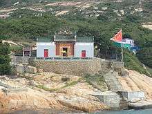
A Tin Hau Temple is located on Po Toi, facing the bay of Tai Wan (大灣). While its construction date is unknown, it is documented that the temple was renovated in 1893.[2][11]
Mo's Old House, or the "Deserted Mansion of Family Mo" (巫氏廢宅), usually referred to as the "Haunted House",[12] is a popular venue of "adventure" for the young visitors. The existing house was built in the 1930s at Chang Shek Pai and has fallen into ruins.[3]
There is a lighthouse on Po Toi.[13]
Transport
The island is accessible mostly by private ferry (kai-to) or water taxi. Tsui Wah Ferry provides scheduled ferry services to connect Po Toi island with Aberdeen and Stanley.[14][15]
In fiction
The climax of John Le Carre's novel The Honourable Schoolboy (the second in the 'Karla trilogy', featuring George Smiley) takes place on Po Toi.[16]
See also
References
- ↑ Lands Department (February 2011), Hong Kong Geographic Data (PDF), retrieved 2011-11-26
- 1 2 Brief Information on proposed Grade Nil Items. Item #1254. Tin Hau Temple
- 1 2 Brief Information on proposed Grade Nil Items. Item #1207. Mo's Old House
- ↑ "Rocks in Po Toi", Varsity, Issue 118, December 2006
- ↑ Exploring Islands. Po Toi sights: Supine Monk
- ↑ Meacham, William (2008). The Archaeology of Hong Kong. Hong Kong University Press. pp. 123–129. ISBN 978-962-209-925-8.
- ↑ Antiquities and Monuments Offices: Rock Carving on Po Toi Island
- ↑ Exploring islands. Po Toi sights: Rock Carving
- ↑ Davis, S. G., S. Edelstein, and M. H. Tang. 1974. "Rock Carvings in Hong Kong and the New Territories". Asian Perspectives 17 (1): 1-4.
- ↑ Environment Protection Department - List of Declared Monuments as on 1 January 1999 (archive)
- ↑ Exploring islands. Po Toi sights: Tin Hau Temple, Po Toi
- ↑ Exploring islands. Po Toi sights: The Old Mansion of Family Mo
- ↑ Lighthouses of China: Hong Kong
- ↑ Tsui Wah Ferry website
- ↑ Transport details for Po Toi Islands
- ↑ Cornwell, David (1977). The Honourable Schoolboy. Hodder and Stoughton. pp. 696–738. ISBN 978-0-340-93762-4.
External links
| Wikimedia Commons has media related to Po Toi. |
- Pictures of Po Toi Island:
- CentaMap map of Po Toi Island
- Hong Kong Bird Watching Society: Proposal for a Site of Special Scientific Interest and Support for Country Park Designation on Po Toi Island, October 2012
Coordinates: 22°10′8.8″N 114°15′48.2″E / 22.169111°N 114.263389°E