Siu A Chau
| 小鴉洲 | |
|---|---|
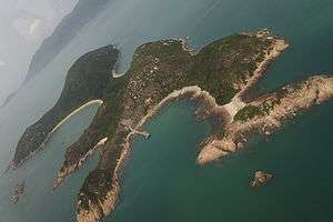 Aerial view of Siu A Chau looking towards the South coast of Lantau Island | |
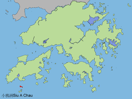 Location of Siu A Chau in Hong Kong. | |
| Geography | |
| Location | South of Lantau Island |
| Highest elevation | 74 m (243 ft) |
| Administration | |
| Siu A Chau | |||||||||
| Traditional Chinese | 小鴉洲 | ||||||||
|---|---|---|---|---|---|---|---|---|---|
| |||||||||
Siu A Chau (Chinese: 小鴉洲) is an uninhabited island[1] of Hong Kong, part of the Soko Islands group, located south of Lantau Island.
Geography
Siu A Chau is the northernmost and the second largest of the Soko Islands, after Tai A Chau. It is dumbbell-shaped[2] and has a rugged indented coastline with steep slopes.[3] The highest point of the island is at 74 meters.[4] A beach lies to the south, and another to the north of the island.[4][5]
History
In 1937, Walter Schofield, then a Cadet Officer in the Hong Kong Civil Service, wrote that Siu A Chau was "another settlement of early man" and that it had a "fishing village of huts very different from ordinary Chinese dwellings" at the time of writing.[2]
Features
There is a temple on the south side of the island.[4]
A low-level radioactive waste (LLRW) facility began operation at Siu A Chau in July 2005. Low-level radioactive wastes which had previously been stored in disused tunnels, two factories and five hospitals were subsequently transferred to the Siu A Chau facility.[6] Part of this waste was relocated from the disused Mount Parish air-raid tunnels at Queen's Road East, in Wan Chai. The 55 m3 of LLRW stored there had raised objections.[7][8] The opening ceremony of the facility was held in June 2006.[9]
References
- ↑ Low Level Radioactive Waste Storage Facility at Siu A Chau. Environmental Monitoring and Audit Manual
- 1 2 W. Schofield: "The islands around Hong Kong (text of a talk given in 1937)", from Journal of the Royal Asiatic Society Hong Kong Branch, Vol. 23, 1983
- ↑ South West New Territories Development Strategy Review. Recommended Development Strategy. July 2001
- 1 2 3 "No Man Is an Island", HK Magazine website, 22 March 2007
- ↑ "Far From the Madding Crowd", HK Magazine website, 8 June 2006
- ↑ Environment Protection Department: Low-level Radioactive Waste
- ↑ Legislative Council Panel on Environmental Affair - PWP Item 70DR - Low-level radioactive waste storage facility, June 2003
- ↑ Item for Public Works Subcommittee of Finance Committee, June 2003
- ↑ Environment Protection Department: Low-level Radioactive Waste Storage Facility opens, 24 June 2006
External links
| Wikimedia Commons has media related to Siu A Chau. |
- Webpage about Siu A Chau Tin Hau Temple (Chinese)
Coordinates: 22°10′57″N 113°54′44″E / 22.18250°N 113.91222°E