Poço Redondo
| Poço Redondo | |||
|---|---|---|---|
| Municipality | |||
| The Municipality of Poço Redondo | |||
| |||
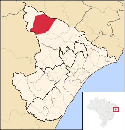 Location of Poço Redondo in the State of Sergipe | |||
| Coordinates: 09°48′21″S 37°41′06″W / 9.80583°S 37.68500°WCoordinates: 09°48′21″S 37°41′06″W / 9.80583°S 37.68500°W | |||
| Country |
| ||
| Region | Northeast | ||
| State |
| ||
| Founded | 1953 | ||
| Government | |||
| • Mayor | Frei Enoque Salvador de Melo (PSB) | ||
| Area | |||
| • Total | 1,212.461 km2 (468.134 sq mi) | ||
| Elevation | 188 m (617 ft) | ||
| Population (2012) | |||
| • Total | 31,614 | ||
| • Density | 26/km2 (68/sq mi) | ||
| [1] | |||
| Time zone | UTC-3 (UTC-3) | ||
| • Summer (DST) | UTC-2 (UTC-2) | ||
| HDI (2000) | 0.536 – medium[2] | ||

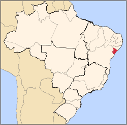
Poço Redondo is a municipality located in the Brazilian state of Sergipe. Its population is 31,614 (2012) and its area is 1,212 km²,[3] which makes it the largest municipality in that state.
References
Capital: Aracaju | |||||||||||||||||||||||||||
| Agreste Sergipano |
|  | |||||||||||||||||||||||||
| Leste Sergipano |
| ||||||||||||||||||||||||||
| Sertao Sergipano |
| ||||||||||||||||||||||||||
This article is issued from Wikipedia - version of the 5/30/2016. The text is available under the Creative Commons Attribution/Share Alike but additional terms may apply for the media files.