Pont de l'Iroise
| Pont de l'Iroise | |
|---|---|
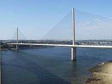 The Pont de l'Iroise, seen from the Plougastel end of the pont Albert-Louppe looking north-east and upriver | |
| Coordinates | 48°23′15″N 04°23′52″W / 48.38750°N 4.39778°WCoordinates: 48°23′15″N 04°23′52″W / 48.38750°N 4.39778°W |
| Carries | N165 road |
| Crosses | Élorn |
| Locale | Finistère |
| Owner | Finistère DDE (Direction Départementale de l'Equipement), Ministry of Public Works |
| Maintained by | Finistère DDE |
| Preceded by | pont Albert-Louppe |
| Characteristics | |
| Design | cable-stayed |
| Material | reinforced concrete, steel |
| Total length | 800.05 metres (2,624 ft 10 in) |
| Width | 23.1 metres (75 ft 9 in) |
| Height | 113 metres (370 ft 9 in) |
| Longest span | 400 metres (1,312 ft 4 in) |
| Number of spans | 7 |
| Piers in water | 2 |
| Clearance below | 26.5 metres (86 ft 11 in) |
| History | |
| Architect | René Le Friant, René Terzian |
| Designer | Michel Placidi |
| Engineering design by | Alain Chauvin; Service d'Etudes Techniques des Routes et Autoroute, SOGELERG |
| Constructed by | Demathieu et Bard; Groupe Razel; Pico |
| Construction begin | 1991 |
| Construction end | 1994 |
| Construction cost | 264 million Francs[1] |
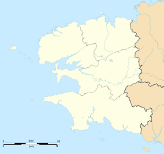 Pont de l'Iroise Location in Finistère | |
The Pont de l'Iroise is a cable-stayed bridge in Finistère, Brittany, France, which spans the Élorn river where it enters the roadstead of Brest. It carries route nationale 165, the road between Brest and Quimper, and connects Le Relecq-Kerhuon to the north with Plougastel-Daoulas to the south. The bridge is named after the Iroise Sea, into which the roadstead of Brest opens.
References
- "Pont de l'Iroise sur la rade de Brest" (PDF) (in French). Setec. Retrieved 25 August 2012.
- Iroise Bridge at Structurae. Retrieved on 2012-08-25.
- Pont de l'Iroise (1994), Sétra 2007
External links
| Wikimedia Commons has media related to Pont de l'Iroise. |
This article is issued from Wikipedia - version of the 4/7/2015. The text is available under the Creative Commons Attribution/Share Alike but additional terms may apply for the media files.