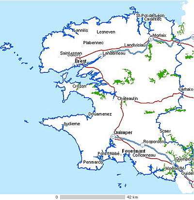
Finistère
| Finistère | |||
|---|---|---|---|
| Department | |||
|
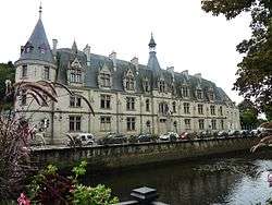
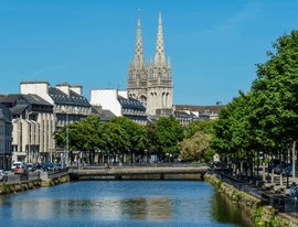
Prefecture building of the Finistère department, in Quimper | |||
| |||
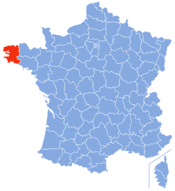 Location of Finistère in France | |||
| Coordinates: 48°15′N 04°00′W / 48.250°N 4.000°WCoordinates: 48°15′N 04°00′W / 48.250°N 4.000°W | |||
| Country | France | ||
| Region | Brittany | ||
| Prefecture | Quimper | ||
| Subprefectures |
Brest Châteaulin Morlaix | ||
| Government | |||
| • President of the General Council | Nathalie Sarrabezolles (PS) | ||
| Area1 | |||
| • Total | 6,733 km2 (2,600 sq mi) | ||
| Population (2013)[1] | |||
| • Total | 903,921 | ||
| • Rank | 24th | ||
| • Density | 130/km2 (350/sq mi) | ||
| Time zone | CET (UTC+1) | ||
| • Summer (DST) | CEST (UTC+2) | ||
| Department number | 29 | ||
| Arrondissements | 4 | ||
| Cantons | 27 | ||
| Communes | 281 | ||
| ^1 French Land Register data, which exclude estuaries, and lakes, ponds, and glaciers larger than 1 km2 | |||

Finistère (French pronunciation: [fi.nis.tɛʁ]; Breton: Penn-ar-Bed Breton pronunciation: [ˌpɛnarˈbeːt]) is a department of France in the extreme west of Brittany.
History
The present department consists of the historical region of Léon and parts of Cornouaille and Trégor, both parts of pre-revolutionary Brittany.
The name Finistère derives from the Latin Finis Terræ, meaning end of the earth. In England, a similar area is called Land's End. The Breton name for Finistère, Penn ar Bed, translates as "Head/End of the World" and is similar to the Cornish name for Land's End, Pedn-an-Wlas (Head/End of the country). Finistère is not to be confused with Finisterre in Galicia, Spain.
Geography
The largest population center in Finistère is Brest. Other large towns in the department include Quimper (the capital), Concarneau, Morlaix, Carhaix, Quimperlé and Douarnenez. Finistère includes the island of Ushant (Eusa in Breton, Ouessant in French).
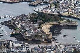
Finistère is the westernmost region of France (excluding the overseas departments in North and South America and the Antillas). By several criteria, Finistère can also claim to be the most coastal department in Metropolitan France. Of its 283 communes, 118 are located on the coast. Its total coastline of approximately 1,250 km (776.71 mi) accounts for almost a quarter of the entire Brittany coast-line.
The abers, rugged fjord-like inlets on the north coast, are a notable feature of the landscape.
The westernmost point of continental France, known as the Pointe de Corsen, extends from the northwestern tip of Finistère. A few miles to the south is the slightly less westerly, but rugged and isolated, headland of Pointe du Raz.
Economy
Agriculture, food processing and various related industries occupy an important place in Finistère's economy.
The military presence in Finistère (Île Longue nuclear submarine base and the Naval Air base of Lanvéoc-Poulmic), as well as military-related industries, such as the Brest headquarters of DCNS, employ a significant number of the département's population.
The port of Roscoff links Brittany by ferry with Ireland and Great Britain.
Culture
Finistère is the area where Breton survives most strongly as a spoken language. Breton-speaking schools are called Diwan, Divyezh and Dihun.
The Festival de Cornouaille, which takes place in Quimper, is a celebration of Breton music and traditions. One of the highlights of summer in Finistère is the "Festival des Vieilles Charrues" held in Carhaix-Plouguer. Major international stars attract tens of thousands of spectators.[2]
The painter Raymond Wintz (1884–1956) featured many locations around Finistère.
Roland Doré sculptor. A sculptor who executed many of the calvaries in Finistère
Tourism
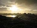
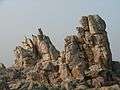 Granite rocks in Ouessant
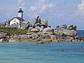 Pontusval lighthouse near Brignogan-Plages
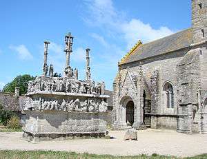
 Pointe du Chateau, Plougrescant
.jpg)
See also
- Cantons of the Finistère department
- Communes of the Finistère department
- Arrondissements of the Finistère department
- Ys
- Calvary at Saint-Herbot near Plonévez-du-Faou and the Chapelle Saint-Herbot.
References
- ↑ INSEE Finistere 2012. Retrieved 10 April 2009.
- ↑ "Vieilles Charrues Festival", official website
External links
| Wikimedia Commons has media related to Finistère. |
| Wikisource has the text of the 1911 Encyclopædia Britannica article Finistère. |
- (French) General Council website
- (French) Prefecture website
- (English) Finistere at DMOZ
- (French) Finistère Tourisme, agence de développement touristique du Finistère