Port Rowan, Ontario
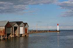
Port Rowan is a town in Norfolk County, Ontario on Lake Erie, adjacent to Long Point. This lakeside community has a population of less than 1000 people and sports a number of traditional small business such as Twins Ice Cream Parlor which has been operating in the town for decades, in addition to a growing retirement population. Every Labour Day weekend, the town throws its annual Bay fest.
History
Key buildings, including John Backhouse`s mill, that date back to the 18th century, remain in existence today.[1] During the War of 1812 American soldiers burned all the mills on Lake Erie`s north shore, from the St Clair River to the Grand River, except for the Backhouse mill, and one other. According to Ron Brown, in ″The Lake Erie Shore: Ontario's Forgotten South Coast″, Backhouse`s mill was skipped due to powerful connections within the USA.
The South Norfolk Railway reached Port Rowan in 1886.[1] It was acquired by the Canadian National Railway, which operated it until 1965.
In 1970 New Democratic Party MPP Morton Shulman asserted that Port Rowan was the destination of secret meetings of mafia leaders.[2]
Economy
During the 18th century fishing, milling, and timber processing were the main industries, exploiting the water power of nearby watercourses.[1] In 1850 the town processed 4,000,000 metres or 13,000,000 feet of timber. 1850 marked the beginning of shipbuilding in Port Rowan.
With the decline of the fishing, lumber and milling industries, tourism is the main economic activity in the region. Local sports include angling and boating in the Long Point Inner Bay and golfing at Stark's Golf Course at the edge of town. Bird Studies Canada is based at Port Rowan. Port Rowan in 2011 built a state of the art Water Treatment Plant, which assures future growth capacity in the town and its burgeoning retirement community.
Its proximity to Long Point, a major bird flight-path, and World Biosphere Reserve, makes Port Rowan a popular destination for bird-watchers.[3] Some of the few remaining stands the old growth Carolinian forest that were present all over Southern Ontario can be found near Port Rowan.
There is a historic replica village nearby at the Backus Conservation Area.[4]
Climate
Port Rowan traditionally belongs to the humid continental climate zone; even with the recent epidemic of mild winters and extremely warm and dry summers. Like in all communities, towns, and cities throughout the world, global warming due to human industrial activity has drastically altered the climate of Port Rowan throughout the decades.
References
- 1 2 3 Ron Brown (2009). "The Lake Erie Shore: Ontario's Forgotten South Coast". Dundurn. pp. 36, 38, 40, 41, 88–90, 91, 126, 127, 128, 153. ISBN 9781554883882. Retrieved 2012-11-23.
During the scorched-earth policy of the invading American militia during the War of 1812, all mills along the Erie shore as far as the Grand River were burned to the ground. All, that is, except the mill belonging to John Backhouse, and Tisdale's mill in Vittoria. It is most likely the invaders did not want to march into the interior, as they thought there was a British garrison at Turkey Point.
- ↑ Bill Hickey (1970-10-08). "Ontario labelled mafia haven". Queen`s Park, Ontario: Windsor Star. p. 72. Retrieved 2012-11-23.
Amid tales of Mafia gatherings at such Ontario centres as Turkey Point, Port Rowan and Toronto, the High Park member alleged that Ontario was rife with organized crime and claimed that OPP were doing nothing to stop it.
- ↑ Margaret Munro (2012-08-26). "Return of the 'hoodies': Tough little bird flies back from the brink of extinction". Port Rowan: Calgary Herald. Retrieved 2012-11-23.
Many of them are songbirds that migrate incredible distances to seek out the few remaining remnants of Carolinian forest that once dominated the region.
- ↑ Paul John Knowles (1998). "Niagara & Southwestern Ontario: A Colourguide". Formac Publishing Company. pp. 59–60. ISBN 9780887804267. Retrieved 2012-11-23.
For a lesson in history dating back two centuries, check out the Backus Conservation Area just north of Port Rowan, where you'll find twenty historic buildings lovingly restored, including the John Backhouse Mill from 1798.
External links
- Harry B. Barrett (1977). "Lore & Legends of Long Point". Burns and MacEachearn. ISBN 9780968608012. Retrieved 2012-11-23.
- David Stone (2003). "Long Point: Last Port of Call". Boston Mills Press. ISBN 9781550460797. Retrieved 2012-11-23.
- Dave Stone, David R. Frew (1993). "The Lake Erie Quadrangle: waters of repose". Erie County Historical Society. pp. 41, 204. ISBN 9781883658205. Retrieved 2012-11-23.
Coordinates: 42°37′19.5″N 80°26′57.0″W / 42.622083°N 80.449167°W