Povoação, Azores
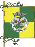
| Povoação | |||
| Municipality (Concelho) | |||
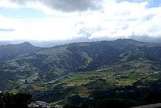
 The municipal seat of the municipality of Povoação located along the lombas of the Povoação crater | |||
|
|||
| Official name: Concelho da Povoação | |||
| Name origin: povoação, Portuguese for population or settled by peoples | |||
| Country | |||
|---|---|---|---|
| Autonomous Region | |||
| Island | São Miguel | ||
| Civil Parishes | Água Retorta, Faial da Terra, Furnas, Nossa Senhora dos Remédios, Povoação, Ribeira Quente | ||
| Center | Pico do Buraco | ||
| - elevation | 580 m (1,903 ft) | ||
| - coordinates | 37°46′43″N 25°16′45″W / 37.77861°N 25.27917°WCoordinates: 37°46′43″N 25°16′45″W / 37.77861°N 25.27917°W | ||
| Highest point | Pico da Vara | ||
| - location | Planalto dos Graminhais | ||
| - elevation | 1,019 m (3,343 ft) | ||
| - coordinates | 37°48′32″N 25°12′48″W / 37.80889°N 25.21333°W | ||
| Lowest point | Sea level | ||
| - location | Atlantic Ocean | ||
| - elevation | 0 m (0 ft) | ||
| Area | 106.41 km2 (41 sq mi) | ||
| - water | 1.94 km2 (1 sq mi) | ||
| - urban | 2.71 km2 (1 sq mi) | ||
| Population | 6,327 (2011) | ||
| Density | 59/km2 (153/sq mi) | ||
| Settlement | c. 1472 | ||
| - Municipality | c. 1839 | ||
| LAU | Câmara Municipal | ||
| - location | Largo do Municipio | ||
| - elevation | 7 m (23 ft) | ||
| - coordinates | 37°44′48″N 25°14′45″W / 37.74667°N 25.24583°W | ||
| President | Carlos Emílio Lopes Machado Ávila (PS) | ||
| Municipal Chair | Benilde Oliveira (PS) | ||
| Timezone | Azores (UTC-1) | ||
| - summer (DST) | Azores (UTC0) | ||
| Postal Zone | 9650-411 | ||
| Area Code & Prefix | (+351) 296 XX XX XX | ||
| Demonym | Povoacense | ||
| Patron Saint | Nossa Senhora da Mãe de Deus | ||
| Municipal Holidays | 3 July; the day after Corpus Christi | ||
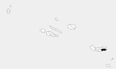 Location of the municipality of Povoação in the archipelago of the Azores | |||
| Wikimedia Commons: Povoação (Azores) | |||
| Statistics: Instituto Nacional de Estatística[1] | |||
| Website: http://www.cm-povoacao.pt | |||
| Geographic detail from CAOP (2010)[2] produced by Instituto Geográfico Português (IGP) | |||

Povoação (Portuguese pronunciation: [puvuɐˈsɐ̃w]) is a municipality located in the southeastern corner of the island of São Miguel in the Portuguese archipelago of the Azores. The population in 2011 was 6,327,[3] in an area of 106.41 km².[4]
History
Colonization of the island is commonly associated with the settlement of Povoação Velha, the first colony on the island of São Miguel.[5] In 1427, Diogo Dilva first arrived in the area of Povoação, accompanied by several men: "Arriving here on the island, the nine discoverers took land in the place where today we call Povoação Velha for which they made later...and, disembarked between two fresh ravines of clear, sweet and cold waters, (the Ribeira de Além and the Ribeira de Pelames) between the cliffs and high lands, (Morro de Santa Bárbara and Lomba dos Pós) all covered in greenery of cedro, laurel, ginger and faias, and other diverse".[5][6] From the beginning, the locality impressed the settlers, since it was abundant in vegetation, to them indicating a fertile land.
In 1432, Gonçalo Velho Cabral, then first Captain-Donatário of São Miguel, chose the locality for the first settlement on the island.[6] From this location they began to transport cattle, wheat seed, legumes and agricultural implements in order to make the settlement viable.[5][6] On 2 July 1439, a royal decree from Infante D. Pedro, regent to King Afonso V, ordered Infante Henry to send sheep to the seven islands of the Azores (until that time Corves and Flores had not been discovered).[6]
During the 18th century, the region became a center of naval construction, owing to the abundance of wood in the immediate area.[6]
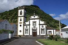
The community of Povoação was elevated to the status of municipality in 1839, when it was de-annexed from the municipality of Vila Franca do Campo and later, Nordeste.[6] The parish church, dedicated to Nossa Senhora da Mãe de Deus (Our Lady The Mother of God), was constructed from 24 July 1848, and emblematic for is gilded wood alterpeices and the image of its patron. On 4 July 1865 the parish council building was first inaugurated, later to be the site of the municipalities local government.
The municipality, and in particular the town of Povoação, was damaged during the 1935 earthquake.[6] Construction on the municipal garden began in the 1940s, during the execution of the reconstruction program for the urban nucleus.[6]
Geography
With an area of 110.30 square kilometres (42.59 sq mi), Povoação is located 60 kilometres (37 mi) east of the regional capital of Ponta Delgada and former historical capital, Vila Franca do Campo, along the southern extent of the Estrada Regional E.R. 1-1ª that circles the entire island.[7] It is bordered on the east and northeast by the municipality of Nordeste, to the north by Ribeira Grande, and west by Vila Franca do Campo.[6]
Physical geography
The municipality occupies the semi-active craters of the Furnas and Povoação volcanoes, circled by forests, mountains and river valleys to the north, west and east, while the Atlantic coast to the south.[6][8] From 100,000 to 95,000 years ago, the Povoação crater, associated with the volcano, consists of volcanic products that were emitted from this volcano of the same name, that overlay the Volcanic Complex of Nordeste.[8] Corresponding basaltic lava flows and other volcanic ejectants, the top of this formation is covered by materials involved in explosive eruptions from the Furnas volcano.[8]
With about 100000-year history, the Furnas volcano is the youngest of the active volcanoes of São Miguel. The rock and mineral deposits are divided into three groups, consisting essentially of trachyte materials, constituted by pyroclastic deposits and flows resulting from explosive eruptions, lava flows and surges.[8] The inferior layer includes most pyroclastic materials and volcanic products in the formation of the Povoação Ignimbrite (some 30000 years ago).[8] The intermediate layer includes material produced between 30,000 years and 5,000 years ago (reaching the Fogo A depoists).[8] Finally, the superior layer includes all activities until 5000 years ago.[8]
Much of the remainder of the land is occupied by agricultural lands, specifically on the fertile plains over the river valleys.[7] These geological structures resulted in a diversified landscape, dotted by parks, lookouts, belvederes, beaches and salient waters, including the Lagoa das Furnas (Lake Furnas) a volcanic crater lake and the manicured gardens of the Terra Nostra Garden (Portuguese: Parque Terra Nostra).[7] The Furnas valley is a source of important horological resources, resulting from the active volcanism of the region, with fumaroles, boiling mud, thermal baths and at least one recognized tepid beach (Ribeira Quente).[7] This valley includes 22 classified mineral-rich medicinal waters (the largest center of its kind).[7]
Human geography
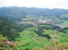
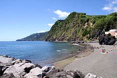
.jpg)
With a population of 7000 inhabitants, the municipality consists of six civil parishes (that administrate local authority), which include:[7]
The largest civil parish (by population and density) is Povoação; the smallest parish is Água Retorta, while Faial da Terra is the most spare community; while Ribeira Quente is the smallest civil parish by area.
Economy
The municipality is sustained by the agriculture and fishing industries, with many of the businesses and commerce situated in the coastal urban center of Povoação. Tourism is also an important part of the regional activities with places like Furnas attracting naturalists and leisure activities.
Architecture

Civic
- Discoverers' Gate (Porta dos Descobrimentos), located on the coast, it is the presumed location that the first discoverers and settlers disembarked on the island at the end of the 1440s.[9]
- District Court of Povoação (Portuguese: Tribunal da Comarca de Povoação) [10]
- Municipal Council of Povoaçao (Paços do Concelho da Povoação), today the main building for the entire municipality, the square building was inaugurated in the 19th century;[11]
- Park and Residence of Murtas (Portuguese: Parque e Casa das Murtas)
- Sub-Regional Hospital of Povoação (Portuguese: Hospital Sub-Regional de Povoação)[10]
- Thermal Spa of Furnas (Portuguese: Estação Termal das Furnas)
Religious
- Chapel of Nossa Senhora das Vitórias (Portuguese: Capela de Nossa Senhora das Vitórias)[12]
- Church of Nossa Senhora da Mãe de Deus (Portuguese: Igreja Paroquial de Povoação/Igreja da Mãe de Deus), inaugurated on 24 July 1848, it is prized for the gild work and historic image of its patron saint;[9][13]
- Church of Nossa Senhora da Graça (Portuguese: Igreja Paroquial de Faial da Terra/Igreja de Nossa Senhora da Graça)
- Church of Nossa Senhora da Penha de França (Portuguese: Igreja Paroquial de Água Retorta/Igreja de Nossa Senhora da Penha de França)
- Church of Nossa Senhora dos Remédios (Portuguese: Igreja Paroquial Nossa Senhora dos Remédios/Igreja Nossa Senhora dos Remédios)
- Church of Nossa Senhora de Rosário (Portuguese: Igreja de Nossa Senhora do Rosário na Praça Velha), most commonly known as the Igreja Velha (the Old Church), it was constructed in 1745, on the precise site that the hermitage and cemetery of Senhora da Consolação (Our Lady of Consolation) was erected;[9][14]
- Church of Santa Ana (Portuguese: Igreja Paroquial das Furnas/Igreja de Santa Ana)
- Church of São Paulo (Portuguese: Igreja Paroquial de Ribeira Quente/Igreja de São Paulo)
- Hermitage of Santa Ana (Portuguese: Ermida de Santa Ana/Igreja Velha)
- Hermitage of Santa Bárbara (Portuguese: Ermida de Santa Bárbara)[15]
References
Notes
- ↑ INE, ed. (2010), Censos 2011 - Resultadas Preliminares [2011 Census - Preliminary Results] (in Portuguese), Lisbon, Portugal: Instituto Nacional de Estatística, retrieved 1 January 2012
- ↑ IGP, ed. (2010), Carta Administrativa Oficial de Portugal (in Portuguese), Lisbon, Portugal: Instituto Geográfico Português, retrieved 1 January 2012
- ↑ Instituto Nacional de Estatística
- ↑ Eurostat
- 1 2 3 Câmara Municipal, ed. (2012). "Concelho da Povoação" (in Portuguese). Povoação (Azores), Portugal: Câmara Municipal da Povoação. Retrieved 17 August 2013.
- 1 2 3 4 5 6 7 8 9 10 Costa, Anouk (2012), SIPA, ed., Núcleo urbano da vila da Povoação (IPA.00027986/PT072104050006) (in Portuguese), Lisbon, Portugal: SIPA – Sistema de Informação para o Património Arquitectónico, retrieved 21 August 2013
- 1 2 3 4 5 6 "Concelho da Povoação - Geografia" (in Portuguese). Povoação (Azores), Portugal: Câmara Municipal da Povoação. 2012. Retrieved 20 August 2013.
- 1 2 3 4 5 6 7 CVARG, ed. (2012). "Unidades Vulcanológicas" (in Portuguese). Ponta Delgada (Azores), Portugal: Centro de Vulcanologia e Avaliação de Riscos Geológicos da Universidade dos Açores/Centro de Informação e Vigilância Sismovulcânica dos Açores.
- 1 2 3 Junta de Freguesia, ed. (2012), Igrejas e Monumentos (in Portuguese), Junta de Freguesia de Povoaçã, retrieved 25 March 2014
- 1 2 Bandeira, Filomena (2003), SIPA, ed., Edifício da Câmara Municipal da Povoação (IPA.00033694/PT072104050016) (in Portuguese), Lisbon, Portugal: SIPA – Sistema de Informação para o Património Arquitectónico, retrieved 25 March 2012
- ↑ Noé, Paula (2012), SIPA, ed., Edifício da Câmara Municipal da Povoação (IPA.00033694/PT072104050016) (in Portuguese), Lisbon, Portugal: SIPA – Sistema de Informação para o Património Arquitectónico, retrieved 25 March 2012
- ↑ CCA, ed. (17 May 2001). "25.00.00 Capela de Nossa Senhora das Vitórias (José do Canto)" (in Portuguese). Angra do Heroísmo (Azores), Portugal: Centro de Conhecimento dos Açores/Direção Regional de Cultura. Retrieved 8 July 2011.
- ↑ Noé, Paula (2012), SIPA, ed., Igreja Paroquial de Povoação/Igreja da Mãe de Deus (IPA.00008143/PT072104050001) (in Portuguese), Lisbon, Portugal: SIPA – Sistema de Informação para o Património Arquitectónico, retrieved 25 March 2012
- ↑ Noé, Paula (2002), SIPA, ed., Igreja de Nossa Senhora do Rosário na Praça Velha (IPA.00008143/PT072104050001) (in Portuguese), Lisbon, Portugal: SIPA – Sistema de Informação para o Património Arquitectónico, retrieved 25 March 2012
- ↑ Noé, Paula (2007), SIPA, ed., Ermida de Santa Bárbara (IPA.00025447/PT072104050005) (in Portuguese), Lisbon, Portugal: SIPA – Sistema de Informação para o Património Arquitectónico, retrieved 25 March 2012
Sources
- Ferreira, T. (2000), Caracterização da actividade vulcânica da ilha de S. Miguel (Açores): vulcanismo basáltico recente e zonas de desgaseificação. Avaliação de riscos. (in Portuguese), Ponta Delgada (Azores), Portugal: University of the Azores, Departamento de Geociências, p. 248
- Guest, J.E.; Gaspar, J.L.; Cole, P.D.; Queiroz, G.; Duncan, A.M.; Wallenstein, N.; Ferreira, T.; Pacheco, J.M. (1999), "Volcanic geology of Furnas Volcano, São Miguel, Azores", Journal of Volcanology and Geothermal Research (in Portuguese), 92, pp. 1–29
- Moore, R.B. (1990), "Volcanic geology and eruption frequency, São Miguel, Azores.", Bulletin of Volcanology, 52, pp. 602–614
- AA.VV., ed. (2005), Livro das paisagens dos Açores, Contributos para a identificação e caracterização das paisagens dos Açores, Ponta Delgada (Azores), Portugal: Direção Regional do Ordenamento do Território e dos Recursos Hídricos
- Almeida, Álvaro Duarte de; Belo, Duarte (2006), Portugal Património, Madeira-Açores (in Portuguese), X, Lisbon, Portugal: Círculo de Leitores, pp. 188–189
- Fernandes, José Manuel (2008), História ilustrada da arquitectura dos Açores (in Portuguese), Angra do Heroísmo: Instituto Açoriano de Cultura
- Frutuoso, Gaspar, Saudades da Terra (in Portuguese), Ponta Delgada (Azores), Portugal: Instituto Cultural de Ponta Delgada, 1977-1987
External links
| Corvo | ||
|---|---|---|
| Faial | ||
| Flores | ||
| Graciosa | ||
| Pico | ||
| Santa Maria | ||
| São Jorge | ||
| São Miguel | ||
| Terceira | ||