Preikestolen
| Preikestolen | |
|---|---|
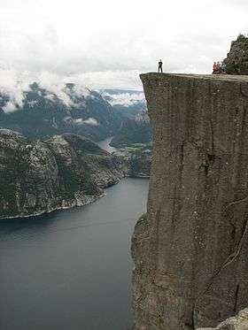 Preikestolen and Lysefjorden | |
| Highest point | |
| Elevation | 604 m (1,982 ft) |
| Coordinates | 58°59′10″N 06°11′19″E / 58.98611°N 6.18861°ECoordinates: 58°59′10″N 06°11′19″E / 58.98611°N 6.18861°E |
| Geography | |
 Preikestolen Location in Rogaland | |
| Location | Rogaland, Norway |
| State/Province | NO |
| Topo map | 1313 III Lyngsvatnet |
| Geology | |
| Mountain type | Granite |
Preikestolen or Prekestolen (English: Preacher's Pulpit or Pulpit Rock) is a famous tourist attraction in the municipality of Forsand in Rogaland county, Norway. Preikestolen is a steep cliff which rises 604 metres (1,982 ft) above the Lysefjorden. Atop the cliff, there is an almost flat top of approximately 25 by 25 metres (82 ft × 82 ft). It sits on the north side of the fjord, opposite the Kjerag plateau, located on the south side.
Tourism at the site has been increasing in recent years, with between 150,000 and 200,000 visitors in 2012,[1] making it one of the most visited natural tourist attractions in Norway. BASE jumpers often leap from the cliff. Due to its increased popularity, there is currently a project under way to improve the path to the site, which is only accessible via a 3.8-kilometre (2.4 mi) long hike.
Name
The old local name of the site is Hyvlatonnå (English: Planed Tooth). The name Prekestolen (without the i) was coined around the year 1900 when the local tourist organisation, Stavanger Turistforening wanted to promote the site for trekking. The "i" was added later to concord with Nynorsk, the official local form of Norwegian, and the site is now known both locally and officially as "Preikestolen."
Access

Preikestolen is located in the southern part of the Ryfylke district in Rogaland county in Western Norway. The city of Stavanger, the fourth largest in Norway, with a number of direct flights between European cities, is located 25 kilometres (16 mi) from the site, and the parking facility for Preikestolen is located about one hour from Stavanger by ferry and car.
Access to Preikestolen from Stavanger is via the Norwegian National Road 13 (Rv13) and the ferry from Tau. From the south, access is by the Rv13 through Sandnes via the ferry from Lauvvika to Oanes. The road is usually open and the ferries running year-round. However, due to snow, it is not always possible to do the hike to the top in the winter.[2]
The road to the site ends in the municipality of Strand, just south of the town of Jørpeland at a parking facility at the Preikestolen Fjellstue, with a trail extending from the parking facility to the site. A round-trip hike to Preikestolen from the closest car park takes about 3–4 hours for someone of average fitness.[3]
The walk to Preikestolen is very steep in places. The path starts at the Preikestolhytta, at an elevation of approximately 270 metres (890 ft) above sea level, and climbs to 604 metres (1,982 ft). The hike takes 1–3 hours depending on traffic along the trail, experience, and fitness level. Even though the elevation differential is only 334 metres (1,096 ft) and the walk is not particularly long, about 3.8 kilometres (2.4 mi) each way, the total elevation gain and loss over the course of the hike is more than one might initially expect, as the path climbs and descends various ridges.
The walk is not recommended in winter and spring when there is snow and ice, and the track may be slippery. The best season to hike the trail is from April to October. Sturdy shoes and rain gear are recommended for the hike.
A convenient alternative is available from mid June to mid August, a tourist ferry from Lauvvik to Lysebotn that passes beneath the Pulpit Rock. Booking well in advance is recommended, as this is a very popular route. A more expensive alternative is to sail through the Lysefjorden, with trips running year-round. Outside of summer, the weather may be wet and cold, and clouds may obstruct views of the cliff. The ship stops at several small docks on the way in and out, including a layover at the end of the Lysefjorden at the village of Lysebotn.[4][5]
Improvement project
In early April 2013, a project started to improve the path up to Preikestolen as the old one is so small that it often causes "delays", and at some points on the path it is sometimes impossible to get through. As of August 2014, the path has been completed. Access to the plateau has been improved and traffic on the way up and down has been much less delayed because of bottlenecks.
Safety
The authorities have opted not to install fencing or other safety devices as they felt it would detract from the natural beauty of the site and the fact that fatalities at the site are extremely rare, despite having approximately 200,000 visitors each year.[6] Furthermore, there were concerns that fences or other devices might encourage dangerous behavior such as climbing onto the fences. It should also be noted that it is a policy from Norwegian authorities that "we cannot fence in all nature in this country", and this is supported by the Norwegian population who are generally more accustomed to "dangerous nature" of their country than foreign tourists.
Up until 2013 there had been no accidental fatalities at the site. However, there were previously suicides and suicide attempts. In February 2000, an Austrian woman and a Norwegian man committed a joint suicide by jumping together off the cliff after meeting on the internet and forming a suicide pact.[7] In October 2004, a young German couple were on their way to the cliff to commit suicide but were stopped by the Norwegian authorities before being able to carry out the act.[8] In 2013 a Spanish tourist became the first person to die from what was ruled an accidental fall;[9] however, there have been indications that this was also a suicide, not an accident.[10]
Nature
Geology
The cliff was formed during the ice age, approximately 10,000 years ago, when the edges of the glacier reached the cliff. The water from the glacier froze in the crevices of the mountain and eventually broke off large, angular blocks, which were later carried away with the glacier. This is the cause of the angular shape of the plateau. Along the plateau itself there continues to be a deep crack. Due to these cracks, the plateau will at some point fall down, but all the geological investigations have revealed that this will not happen in the foreseeable future, and geologists have confirmed the safety of the plateau.[1]
Climate
Along the fjord there is a mild and humid coastal climate.[11]
Surrounding landscape
The cliff overlooks the lush green valleys of the Ryfylke region. The mountains surrounding the cliff reach heights of up to 843 metres (2,766 ft). Some of the hilltops have plains which are interspersed with lakes.
Nearby, close to the bottom of the Lysefjorden, is the 1,110-metre (3,640 ft) tall mountain Kjerag which is also a very popular hiking destination. Recently, some tourists have elected to forego trips to the increasingly popular and crowded Preikestolen and go to Kjerag instead.
Trivia
- A granite sculpture of the cliff was erected in the town Langeskov in Denmark to commemorate its twin town of Forsand.[12]
- In the final scene of the final episode of the second season of Vikings the main character, Ragnar Lothbrok, is seen sitting atop Preikestolen.
- Compressed air from Lysefjorden/Preikestolen is being sold in cans, mostly to China.[13]
Gallery
 Lysefjord seen from the top of the Preikestolen hill
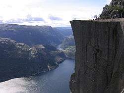
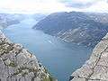 View from Preikestolen, Lysefjorden below
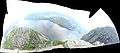 Panoramic view from Preikestolen on Lysefjorden
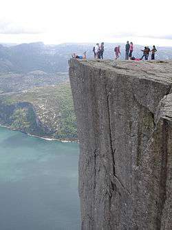
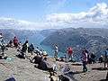 On top of Preikestolen, June 2009
 Preikestolen and surrounding area
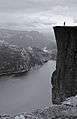 View of Preikestolen in B&W
See also
- Besseggen
- De syv søstre
- Kjerag
- Kjeragbolten
- Trollgaren
- Trollstigen
- Trolltunga
- Trollveggen
- List of waterfalls
References
- 1 2 Mikalsen, Knut-Erik (17 July 2012). "Kan Preikestolen falle ned?" (in Norwegian). Aftenposten. Retrieved 23 July 2012.
- ↑ "Top Hikes: The Pulpit Rock (Preikestolen)". NextStopNorway.
- ↑ Karlsen, Gard (May 2003). "Trip to Preikestolen (Pulpit Rock)". Retrieved 2008-08-18.
- ↑ "Rogaland - Norled". norled.no.
- ↑ "Lysefjordsightseeing". Rødne Fjord Cruise.
- ↑ Knutsen, Håvard T.; Stenberg, Inger Johanne (9 October 2013). "– Vi har alltid fryktet at dette kunne skje" (in Norwegian). NRK. Retrieved 10 October 2013.
- ↑ "Inngikk dødspakt". VG.
- ↑ "Ville hoppe fra Prekestolen". dagbladet.no.
- ↑ Aol travel. "Spanish tourist first to die at Norway's Pulpit Rock - AOL Travel UK". AOL Travel UK.
- ↑ "Preikestolen-dødsfall kan ha vært planlagt". fvn.no.
- ↑ "Områdebeskrivelse" (in Norwegian). Preikestolen nasjonalpark. Retrieved 23 July 2012.
- ↑ "Foreningen NORDEN, Langeskov.". Retrieved 23 July 2012.
- ↑ "Selger frisk luft fra Preikestolen på eBay". Stavanger Aftenblad. Retrieved 15 August 2016.
External links
| Wikimedia Commons has media related to Preikestolen. |
- Preikestolen – 360* Panoramic Pictures – Virtual Norge
- Ryfylke.com
- Preikestolen
- Prekestolhytta.no
- Pulpit Rock