Presidente Venceslau
| Presidente Venceslau | |
|---|---|
| Municipality | |
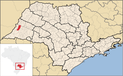 Location in São Paulo state | |
 Presidente Venceslau Location in Brazil | |
| Coordinates: 21°52′34″S 51°50′38″W / 21.87611°S 51.84389°WCoordinates: 21°52′34″S 51°50′38″W / 21.87611°S 51.84389°W | |
| Country |
|
| Region | Southeast Region |
| State | São Paulo |
| Area | |
| • Total | 755 km2 (292 sq mi) |
| Population (2015) | |
| • Total | 39,407 |
| • Density | 52/km2 (140/sq mi) |
| Time zone | BRT/BRST (UTC-3/-2) |
Presidente Venceslau is a municipality in the state of São Paulo in Brazil. The population is 39,407 (2015 est.) in an area of 755 km².[1] The elevation is 422 m. The municipality was named after Venceslau Brás, former president of Brazil.
The municipality contains part of the 7,720 hectares (19,100 acres) Rio do Peixe State Park, created in 2002.[2]
References
- ↑ Instituto Brasileiro de Geografia e Estatística
- ↑ PES do Rio do Peixe (in Portuguese), ISA: Instituto Socioambiental, retrieved 2016-11-12
This article is issued from Wikipedia - version of the 11/13/2016. The text is available under the Creative Commons Attribution/Share Alike but additional terms may apply for the media files.