Promethei Terra
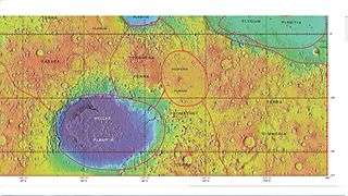

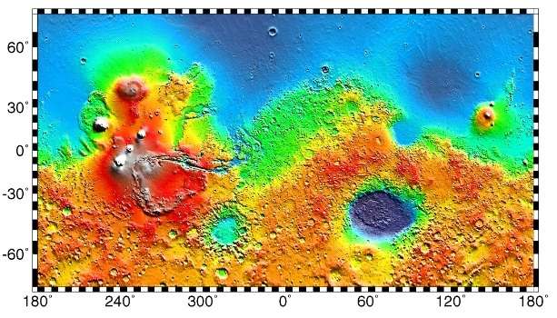
Promethei Terra is a large Martian region covering 3300 km at its broadest extent. It lies to the east of the massive Hellas basin. Like much of the southern part of the planet it is a heavily cratered, highland region. Promethei Terra was named for a classic albedo feature of Mars, with the original name derived from that of the Greek god Prometheus. Promethei Terra lies mostly in the Hellas quadrangle of Mars.
Lobate debris aprons
One very important feature common in Promethei Terra are piles of material surrounding cliffs. These materials are called lobate debris aprons (LDAs). Recently, research with the Shallow Radar on the Mars Reconnaissance Orbiter has provided strong evidence that the LDAs are glaciers that are covered with a thin layer of rocks. Large amounts of water ice are believed to be in the LDAs. Available evidence strongly suggests this area accumulated snow in the past. When the tilt (obliquity) of Mars increases the southern ice cap releases large amounts of water vapor. Climate models predict that when this occurs water vapor condenses and falls where LDAs are located. The tilt of the earth changes little because our relatively large moon keeps it stable. The two tiny Martian moons do not stabilize its planet, so the rotational axis of Mars undergoes large variations.[1] It has been known for some time that Mars undergoes many large changes in its tilt or obliquity because its two small moons lack the gravity to stabilize it, as our moon stabilizes Earth; at times the tilt has even been greater than 80 degrees[2][3]
Lobate debris aprons may be a major source of water for future Mars colonists. Their major advantage over other sources of Martian water are that they can easily mapped from orbit and they are closer to the equator where manned missions are more likely to land.
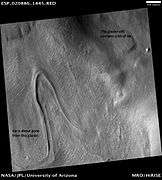
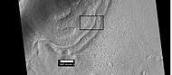 Context for the next image of the end of a flow feature, also called a lobate debris apron. It is probably a glacier. Location is Hellas quadrangle.
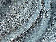 Close-up of the area in the box in the previous image. This may be called by some the terminal moraine of a glacier. For scale, the box shows the approximate size of a football field. Image taken with HiRISE under the HiWish program. Location is Hellas quadrangle.
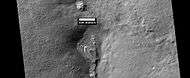
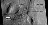 Material Flowing through a crater rim, as seen by HiRISE, under the HiWish program. Lateral moraines are labeled.
Glacier-like forms
Many formations are probably glaciers or the remains of old glaciers because they look so much like glaciers on the Earth.
 Glaciers, as seen by HiRISE, under HiWish program. Glacier on left is thin because it has lost much of its ice. Glacier on the right, on the other hand, is thick; it still contains a lot of ice that is under a thin layer of dirt and rock.
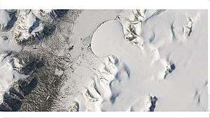 Romer Lake's Elephant Foot Glacier in the Earth's Arctic, as seen by Landsat 8. This picture shows several glaciers that have the same shape as many features on Mars that are believed to also be glaciers.
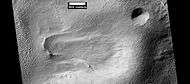 Flow feature that was probably a glacier, as seen by HiRISE under HiWish program
Gallery
 Layered feature of unknown origin, as seen by HiRISE under HiWish program.
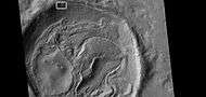 Crater floor with the shape of an odd face, as seen by HiRISE under HiWish program. The box indicates where the next picture is located.
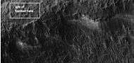 Close-up of a portion of a crater wall indicated in the previous photo. There seems to be grooves in the wall. Picture was taken with HiRISE under HiWish program.
Interactive Mars map
See also
References
- ↑ Holt, J. et al., 2008. Science 322:1235–1238.
- ↑ name= Touma J. and J. Wisdom. 1993. The Chaotic Obliquity of Mars. Science 259, 1294-1297.
- ↑ Laskar, J., A. Correia, M. Gastineau, F. Joutel, B. Levrard, and P. Robutel. 2004. Long term evolution and chaotic diffusion of the insolation quantities of Mars. Icarus 170, 343-364.
External links
| Wikimedia Commons has media related to Promethei Terra. |
- Geologic Map of Reull Vallis Region of Mars, includes the highlands of eastern Promethei Terra, by Astrogeology Science Center, U.S. Geological Survey
- Martian Ice - Jim Secosky - 16th Annual International Mars Society Convention
- Google Mars centered on Promethei Terra
- European Space Agency images of Promethei Terra
- THEMIS