Pucajirca
This article is about the mountain in the provinces of Huaylas and Pomabamba, Ancash Region, Peru. For other uses, see Puka Hirka (disambiguation).
| Pucajirca | |
|---|---|
|
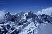
Pucajirca Oeste (on the left), Rinrijirca (middle-left) and Curuicashajana (on the right) behind the Arway Glacier and Arwayqucha | |
| Highest point | |
| Elevation | 6,046 m (19,836 ft) |
| Coordinates | 8°50′59″S 77°35′43″W / 8.84972°S 77.59528°WCoordinates: 8°50′59″S 77°35′43″W / 8.84972°S 77.59528°W |
| Geography | |
 Pucajirca Peru | |
| Location | Peru, Ancash Region |
| Parent range | Andes, Cordillera Blanca |
| Climbing | |
| First ascent | 1961, S. Nakagawa, H. Nakajima, T. Nakamura. |

Pucajirca[1][2] or Pucahirca[2] (possibly from Quechua puka red, Ancash Quechua hirka mountain,[3] "red mountain") is a mountain in the Cordillera Blanca in the Andes of Peru, about 6,046 m (19,836 ft) high.[1][2] It is located in the Ancash Region, Pomabamba Province, Pomabamba District (Pucajirca Norte) as well as in the Huaylas Province, Yuracmarca District (Pucajirca Central)[4] north of Rinrijirca.[1]
Pucajirca as seen from the summit of Alpamayo
The mountain has three separate and independent summits: Pucajirca Norte (6,046 m), Central (6,014 m) and Oeste (6,039 m).[1]
See also
References
- 1 2 3 4 Alpenvereinskarte 0/3a. Cordillera Blanca Nord (Peru). 1:100 000. Oesterreichischer Alpenverein. 2005. ISBN 3-928777-57-2.
- 1 2 3 Biggar, John (2005). The Andes: A Guide for Climbers. Andes. p. 60. ISBN 9780953608720.
- ↑ "Vocabulario comparativo, quechua ecuatoriano - quechua ancashino - castellano - English, Brighton 2006" (PDF). Robert Beér, Armando Muyolemaj, Dr. Hernán S. Aguilarpaj. Retrieved October 2, 2015.
- ↑ escale.minedu.gob.pe - Map of the Huaylas Province
This article is issued from Wikipedia - version of the 7/14/2016. The text is available under the Creative Commons Attribution/Share Alike but additional terms may apply for the media files.